Forecast for the Uintas Area Mountains

Trent Meisenheimer
Issued by Trent Meisenheimer for
Friday, February 19, 2016

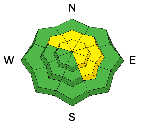
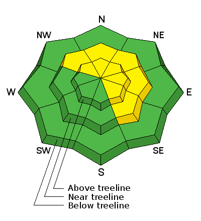
At and above treeline, a MODERATE avalanche danger exists on steep wind loaded slopes. Any avalanche that breaks on weak, sugary snow near the ground will be deep and and dangerous.

Out of the wind effected terrain and on slopes under 35 degrees in steepness we have a Low avalanche hazard. The best and safest riding can be found on low angle slopes that face the north (shady) side of the compass.

Low
Moderate
Considerable
High
Extreme
Learn how to read the forecast here
Special Announcements

Here's a great new video which defines responsibilty to ourselves and others in the backcountry-

Backcountry Responsibility Objective from Trent Meisenheimer on Vimeo.

Weather and Snow

Clear skies and cold temperatures this morning, winds have slowed down and are blowing at a more reasonable speed across the high terrain. West south west winds at 10,000 feet are blowing 20-30mph and gusting into the 40's. We picked up 3-4 inches of dense heavy snow across the range from yesterday's ferocious storm.

The new snow should of bonded quite well to the old snow surface - however, I am not convince that 4 inches of new snow covered up all the old tracks and weird conditions from the onslaught of last weeks high pressure.

Trip reports and observations are found here.

Recent Avalanches

No new avalanche activity was reported yesterday. However, I don't think many people were in the backcountry yesterday.

Recent avalanche observations are found here

See or trigger an avalanche? Shooting cracks? Hear a collapse? It's simple. Go here to fill out an observation.

Ad
Avalanche Problem #1
Wind Drifted Snow
Type
Location
Likelihood
Size
Description

Yesterday's winds ranged throughout the Uintas and at 11,000 feet gusts of 114mph were recorded as a powerful storm system cut through northern Utah. As a result, wind slabs developed on the lee (opposite) side of ridge lines. At and above tree line and on terrain steeper than 35 degrees look for fresh drifts of wind blown snow on any terrain feature, including, gulleys, road cuts, chutes, break overs, and creek bottoms. Fresh drifts look rounded and pillowy.

Fresh wind slabs will be sensitive to the weight of rider and are found in unusual places today due to the strong winds. The good news is that wind slabs settle out very quickly and by tomorrow will not be a problem. For today, leave them alone.

Picture taken Wednesday as the winds started to move the snow around. (Kikkert Photo)

Avalanche Problem #2
Persistent Weak Layer
Type
Location
Likelihood
Size
Description

Today's wind slabs are the biggest concern, but even a small slide can break to weak sugary snow near the ground. It's becoming harder to trigger a deep, dangerous avalanche, but we are still finding weak sugary snow below, with stronger, more dense snow above. Steep, mid and upper elevation terrain facing the north half of the compass, particularly slopes that previously avalanched are suspect and need careful evaluation.

The last reported deep slab avalanche was in Race Track Bowl February 13th 2016 and reported here .

Additional Information

We will have clear, sunny skies to start the day today and temperatures will be on the rise topping out in the upper 20's to low 30's. We could see a few thin high clouds stream overhead as the day progresses. Winds should behave, blowing out of the southwest 15-25mph with the occasional gust in the 30's at 10,000 feet. Overnight temperatures will dip into the teens as a very weak disturbance clips northern Utah tonight and into tomorrow bringing cooler temps, clouds and no precipitation.

General Announcements

Remember your information can save lives. If you see anything we should know about, please participate in the creation of our own community avalanche advisory by submitting snow and avalanche conditions. You can call me directly at 801-231-2170, email [email protected], or email by clicking HERE If Craig is unavailable you can reach his partner Trent at 801-455-7239, email [email protected]

This is a great time of year to schedule a free avalanche awareness presentation for your group or club. You can contact me at 801-231-2170 or email [email protected]. To register for the first in our series of on-the-snow sled specific classes you can register here.

The information in this advisory is from the US Forest Service which is solely responsible for its content. This advisory describes general avalanche conditions and local variations always occur.

The information in this advisory expires 24 hours after the date and time posted, but will be updated by 7:00 AM on Saturday, February 20th.