

Forecast for the Logan Area Mountains

Thursday morning, February 18, 2016
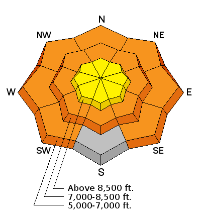
CONSIDERABLE (level 3): Dangerous avalanche conditions exist today on rain saturated slopes at lower and mid elevations, and people should continue to stay off of and out from under steep slopes with soft and saturated snow. Heightened conditions will probably develop and triggered avalanches are possible at upper elevations as strong westerly winds during periods of heavy snowfall will cause significant drifting. Careful snowpack evaluation, cautious route finding, and conservative decision-making will be essential again today in the backcountry.
 Special Announcements
We are offering an Avalanche Awareness for Snowmobilers Course on February 25 & 27. For more information and to register go..... HERE
 Weather and Snow
Expect dropping temperatures and very strong west winds in the mountains, rain (at least this morning) below about 7500', a shot of heavy snow at upper elevations (3 to 7 inches of accumulation), and possible thunder and lightning. The 8400' Tony Grove Snotel reports 35 degrees this morning and there's 72 inches of total snow containing 101% of average water content for the date. I'm reading 28 degrees at the 9700' CSI Logan Peak weather station, and south winds averaging almost 45 mph and gusting to 76 early this morning. The snow at mid and lower elevations yesterday was still very soft, inverted, and saturated by rain. Lacking a good overnight freeze again and with a bit of rain forecast today, dangerous wet avalanche conditions will again probably exist at lower elevations. Observers have noted a rime-crust at upper elevations, which appears to be thicker as you head north... In some areas the ice-crust capping loose powder situation is making for very challenging and perhaps dangerous riding conditions..
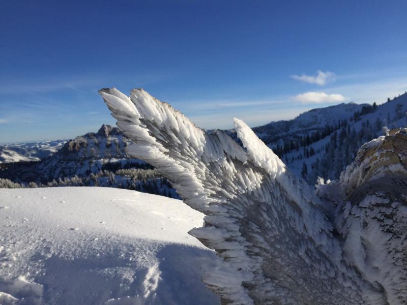
A 2" thick coating of rime ice coveres a small Limber Pine in open upper elevation terrain near Naomi Peak in the Tony Grove Area. (Wolford 2-16-16)
 Recent Avalanches
- On Tuesday afternoon (2-16-16) a fisherman witnessed a large natural wet avalanche come crashing into the stream just in front of him, while he was wading (and catching fish) in the Logan River below Temple Fork
- A wet avalanche crossed Hwy 89 in Logan Canyon at the Dugway at around 2:30 Monday afternoon... The highway was quickly cleared by a UDOT crew in the area. Remember you don't want to try to hand dig a route around avalanches on the road because you expose yourself to following avalanches which are likely in many areas..
- Large natural wet avalanches occurred overnight and during the day Monday, and continued for the last few days in Logan Canyon and at lower and mid elevations across the zone.
-
***To view our updated list of backcountry observations and avalanche activity from around Utah, go to our observations page

Wet Snow

Description
Wet avalanches are likely again today at low elevations as rain continues to dampen the existing weak and already saturated snow. Cooler temperatures and perhaps a good freeze tonight will help to solidify and stabilize the loose wet snow, but significant loose wet avalanches involving saturated soft snow remain likely on steep slopes below the rain/snow line... Dangerous triggered wet slab avalanches are possible in some low elevation areas with saturated snow and poor snow structure.
Wind Drifted Snow

Description
A thick rime or rain crust formed up at upper elevations in many areas and appears be welding most of the existing wind slabs in place, but new drifts will quickly form as heavy snow accumulates during very strong west winds. Expect to find drifts forming well off ridge lines and perhaps in unexpected places.
- Very strong west wind today during periods of heavy snowfall will quickly create fresh drifts, some well off ridges and in normally sheltered terrain.
- Watch for and avoid drifts on the lee sides of ridges, cross-loaded along sub-ridges, and they formed in and around terrain features like rock outcroppings, gullies, scoops, trees, and saddles.
- Beware the growing and overhanging ridge-top cornices, which could break further back than you expect and could trigger wind slab avalanches on drifted slopes below.
- ***Persistent and/or deep slab avalanches are still possible on drifted slopes in outlying areas with shallow weak snow.
Additional Information
A FAST MOVING PACIFIC STORM SYSTEM WILL BRING A STRONG COLD FRONT THROUGH THE REGION TODAY. WEAK STORM SYSTEMS WILL IMPACT PRIMARILY NORTHERN UTAH FRIDAY NIGHT INTO SATURDAY AS WELL AS SUNDAY NIGHT INTO MONDAY.
Today: Snow showers. Some thunder is also possible. Temperature falling to around 23 by 5pm. Windy, with a west wind 36 to 44 mph, with gusts as high as 60 mph. Chance of precipitation is 100%. Total daytime snow accumulation of 3 to 7 inches possible.
Tonight: A 40 percent chance of snow showers. Mostly cloudy, with a low around 22. Windy, with a west southwest wind 23 to 30 mph, with gusts as high as 44 mph. New snow accumulation of around an inch possible.
Friday: Partly sunny, with a high near 36. South southwest wind 10 to 15 mph.
General Announcements
Please submit snow and avalanche observations from your ventures in the backcountry HERE. You can call us at 801-524-5304 or email HERE, or include #utavy in your Instagram or Tweet us @UAClogan. To report avalanche activity in the Logan Area or to contact the local avalanche forecaster call me, Toby, at 435-757-7578.
We'll update this advisory throughout the season on Monday, Wednesday, Friday, and Saturday mornings by about 7:30
This advisory is produced by the U.S.D.A. Forest Service, which is solely responsible for its content. It describes only general avalanche conditions and local variations always exist.
Backcountry Responsibility Objective from Trent Meisenheimer on Vimeo.