Forecast for the Moab Area Mountains

Eric Trenbeath
Issued by Eric Trenbeath for
Wednesday, February 17, 2016

With daytime heating the avalanche danger will rise to MODERATE on steep, sun exposed slopes. Look for signs of instability such as sloppy, wet snow, or roller balls and pinwheels, and get off of and out from under steep, sun exposed slopes when these signs are present.

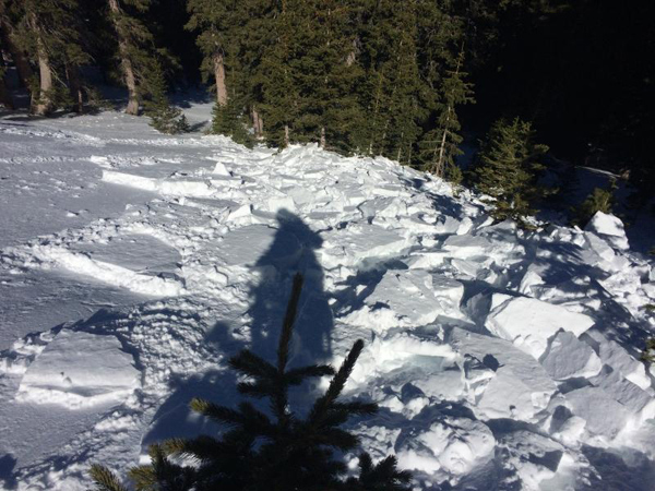
There also remains an isolated or MODERATE danger for triggering a persistent slab avalanche, or old, hard wind slab on steep, upper elevation northerly facing aspects, primarily in areas of shallow snow, and in rocky, more radical terrain.

Elsewhere the avalanche danger is generally LOW.

Low
Moderate
Considerable
High
Extreme
Learn how to read the forecast here
Weather and Snow

Temperatures are about 10 degrees warmer this morning then they were yesterday at this time and it is currently 32 degrees at the Geyser Pass Trailhead and 31 degrees on Pre Laurel Peak. Winds have shifted to the southwest and are averaging 15-20 mph along ridge tops. They will increase today ahead of a fast moving storm system that will move through the region tomorrow. The snow surface continues to be a mixed bag of mostly wind and sun crusts.

Where did all the snow go? View north from the summit of Haystack Mountain.


Southeast side of Haystack Mountain. Wind damaged snow exists on all aspects which is hindering the corn snow process. You have to seek out very sheltered areas to find smooth snow.


Looking down the north face of Haystack Mountain. Northwest winds have scoured out the upper elevations.

Winds, temperature and humidity on Pre-Laurel Peak

New snow totals, temperature and humidity in Gold Basin

Total snow depth and temperature at Geyser Pass Trailhead

Recent Avalanches

I received this report of a snowboard triggered, shallow, hard wind slab near Colorado Bowl that occurred on Saturday. The avalanche was triggered on a north facing aspect around 11,000' in wind exposed terrain. These types of wind slabs can be difficult to detect as they are often wind etched on the surface and they lay scattered behind subtle terrain features in otherwise wind scoured terrain.


Ad
Avalanche Problem #1
Wet Snow
Type
Location
Likelihood
Size
Description

Sunny skies and warm temperatures in the mid 40's at 10,000' will again increase the danger for wet slide activity on sun exposed slopes. Be alert to signs of instability such as wet, sloppy, or punchy snow, roller balls, and pinwheels. Stay off of and out from under steep, sun exposed slopes when these signs are present.

Avalanche Problem #2
Persistent Weak Layer
Type
Location
Likelihood
Size
Description

In general, the danger for triggering a persistent slab, or deep persistent slab is growing increasingly unlikely and north facing aspects are mostly stable. Areas where you may still encounter a problem are on steep, northerly facing aspects where the snow is shallow, or in areas of extreme rocky terrain.

Additional Information

Today

Mostly sunny, with a high near 45. Breezy, with a south southwest wind 15 to 20 mph, with gusts as high as 35 mph.

Tonight

A 30 percent chance of snow, mainly after 4am. Mostly cloudy, with a low around 35. Windy, with a southwest wind 25 to 30 mph, with gusts as high as 45 mph.

Thursday

A chance of snow before 11am, then a chance of snow showers after 11am. Cloudy, with a high near 36. Windy, with a southwest wind 30 to 35 mph, with gusts as high as 60 mph. Chance of precipitation is 50%. New snow accumulation of less than a half inch possible.

Thursday Night

A chance of snow showers before 11pm, then a slight chance of snow after 11pm. Mostly cloudy, with a low around 20. Windy, with a west wind 20 to 30 mph becoming west southwest 5 to 10 mph after midnight. Winds could gust as high as 45 mph. Chance of precipitation is 40%.

Friday

Mostly sunny, with a high near 34. South southwest wind 10 to 15 mph.

Friday Night

Partly cloudy, with a low around 28.

Saturday

Mostly sunny, with a high near 37.

General Announcements

Road Conditions: The road is plowed but getting sloppy and muddy.

Grooming: The trails were groomed on Monday.

To post an observation go here. You can view Moab observations here. You can also give me a call on my cell phone at 801-647-8896

To receive this advisory by email go here.

This information does not apply to developed ski areas or highways where avalanche control is normally done. This advisory is from the U.S.D.A. Forest Service, which is solely responsible for its content. This advisory describes general avalanche conditions and local variations always exist.