Forecast for the Skyline Area Mountains

Brett Kobernik
Issued by Brett Kobernik for
Tuesday, February 16, 2016

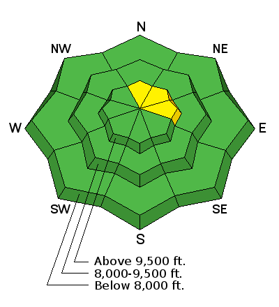
The avalanche danger remains about the same although chances of triggering a slide on the higher north through east facing steep terrain becomes less each day. A MODERATE danger still exists in those steep slopes. Human triggered avalanches are still possible on the described slopes which have already avalanched earlier this season. Outside of the described terrain, the avalanche danger is generally LOW.

Low
Moderate
Considerable
High
Extreme
Learn how to read the forecast here
Weather and Snow

The Skyline picked up a trace of snow from the small storm that moved through on early Monday. Northwest wind was blowing along the ridges and a bit gusty in places down into the drainages as well. Temperatures were cooler than they have been with daytime ridgetop highs around 30.

Ad
Additional Information

General Announcements

We will publish full detailed advisories Saturday and Sunday mornings by 7am. We will also be publishing basic avalanche danger ratings & info during the week.

If you are getting out into the mountains, we love to hear from you! You can SUBMIT OBSERVATIONS ONLINE or EMAIL US

If you would like to have avalanche advisories emailed to you, SIGN UP HERE

We can provide basic avalanche awareness presentations for your school, group or club. To enquire, CLICK HERE