Forecast for the Abajo Area Mountains

Eric Trenbeath
Issued by Eric Trenbeath for
Sunday, February 14, 2016

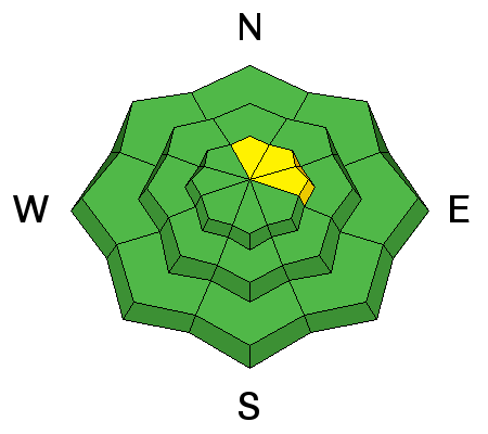
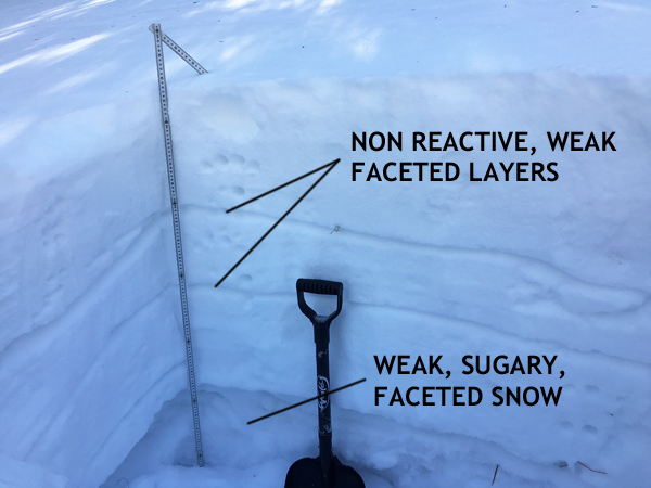
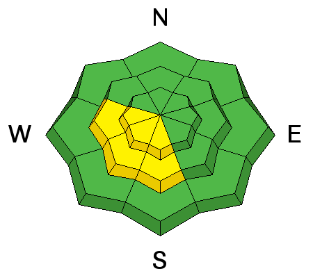
The avalanche danger is generally LOW but there remains a very isolated, or MODERATE danger for triggering a deep avalanche to the ground on steep, upper elevation, northerly aspects. Suspect steep slopes with convex break-overs or areas of rocky, more radical terrain.

And with daytime heating, the danger for loose wet avalanche activity may rise to MODERATE on sun exposed slopes in the afternoon.

Low
Moderate
Considerable
High
Extreme
Learn how to read the forecast here
Special Announcements

Thanks to the Canyon Country Discovery Center for hosting Monticello's first Know Before You Go presentation, and to everyone who turned out and made it a success!

Weather and Snow


It's a mixed bag of spring like conditions out there. Wind and sun have taken their toll on the snow surface in exposed areas. Soft, powder-like snow can be found on sheltered, shady aspects. Varying degrees of breakable crust can be found on sunny slopes, with supportable corn snow developing on due south aspects.


Winds, temperature and humidity on Abajo Peak.

Snow totals at Buckboard Flat.

Snow totals at Camp Jackson.

Avalanche Problem #1
Persistent Weak Layer
Type
Location
Likelihood
Size
Description

Time and warm temperatures have largely healed instabilities within the snowpack. Snowpits reveal some weak layers, but they aren't reacting to applied stress. The only concern at this point is weak, sugary, faceted snow at the ground. It is growing increasingly unlikely that you will trigger an avalanche down to this weak snow but if you did, it would be large and dangerous. You are mostly likely to find this isolated problem on steep, upper elevation slopes with a northerly aspect. Suspect areas with steep, convex rolls in and around rocky, more radical terrain.


I dug this snowpit on a north facing aspect near North Creek Pass. The weak, sugary, faceted snow also known as depth hoar is the primary concern.

Avalanche Problem #2
Wet Snow
Type
Location
Likelihood
Size
Description
Additional Information

A system moving through the region well to our north will leave us with residual blustery conditions under mostly sunny skies. Wee may get a shot at some snow by midweek.

Today

Mostly sunny, with a high near 39. Breezy, with a northwest wind 20 to 25 mph, with gusts as high as 40 mph.

Tonight

Partly cloudy, with a low around 25. Blustery, with a north northwest wind 20 to 25 mph, with gusts as high as 40 mph.

Washington's Birthday

Mostly sunny, with a high near 37. Breezy, with a north northwest wind 20 to 25 mph.

Monday Night

Partly cloudy, with a low around 28. Blustery, with a north wind 15 to 20 mph.

Tuesday

Sunny, with a high near 43. North wind around 15 mph.

Tuesday Night

Mostly clear, with a low around 31.

Wednesday

Mostly sunny, with a high near 45.

General Announcements

Let me know what you are seeing down there by posting an observation here. You can also call me on my cell phone at 801-647-8896

To receive this advisory by email go here.

This information does not apply to developed ski areas or highways where avalanche control is normally done. This advisory is from the U.S.D.A. Forest Service, which is solely responsible for its content. This advisory describes general avalanche conditions and local variations always exist.