Observation: Moffit Peak

Observation Date
2/11/2016
Observer Name
Ted Scroggin
Region
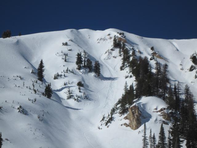
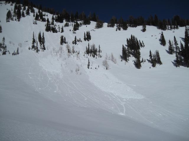
Uintas » Bear River Ranger District » Bear River West Fork » Moffit Peak SE Face
Location Name or Route
Moffit Peak
Weather
Sky
Clear
Wind Direction
West
Wind Speed
Light
Weather Comments
Another clear beautiful day in the Uintas with barely a surface refreeze this morning and warm temperatures starting about mid-morning. Only light ridge top winds from the west and the snow is pretty much settled in place with no snow transport.
Snow Characteristics
Snow Surface Conditions
Dense Loose
Faceted Loose
Melt-Freeze Crust
Damp
Snow Characteristics Comments
The high elevation north facing slopes are still riding and turning quite well with nice settled dense snow. Any change in aspect and you quickly pick-up damp snow or a melt-freeze crust.
Red Flags
Red Flags
Rapid Warming
Red Flags Comments
The wet activity has started on the due south facing slopes with some small point releases that quickly entrain a decent amount of snow as they move down hill.
Avalanche Problem #1
Problem
Wet Snow
Trend
Increasing Danger
Problem #1 Comments
With another warm day tomorrow and a poor refreeze tonight, I would suspect more wet loose activity on both east through west facing slopes.
Avalanche Problem #2
Problem
Persistent Weak Layer
Trend
Same
Problem #2 Comments
This problem is likely getting more isolated with time, but there might still be some areas that have a thin weak snow pack ( steep, rocky ) where a person could find the right weak spot on the slope.
Comments
Some minor wet loose activity that looked to have started near some rocks that heated-up on an east facing slope on Moffit Peak.
The south facing slopes are really taking on some heat and the wet activity has increased the last few days.
Today's Observed Danger Rating
Moderate
Tomorrows Estimated Danger Rating
Moderate