Forecast for the Skyline Area Mountains

Brett Kobernik
Issued by Brett Kobernik on
Friday morning, January 29, 2016

The majority of the terrain has a LOW to MODERATE danger today. However, a CONSIDERABLE avalanche danger still exists in the upper elevation north through southeast facing terrain where a person could trigger an avalanche that breaks into weak snow near the ground.

THE DANGER WILL INCREASE INTO THE WEEKEND AS THE NEXT WARM WINDY STORM MOVES THROUGH.
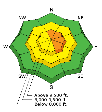
Low
Moderate
Considerable
High
Extreme
Learn how to read the forecast here
Weather and Snow

West winds will start to increase as the day goes on which may transport snow onto the east facing slopes making them more dangerous.

Ad
Additional Information

General Announcements

We will publish full detailed advisories Saturday and Sunday mornings by 7am. We will also be publishing basic avalanche danger ratings & info during the week.

If you are getting out into the mountains, we love to hear from you! You can SUBMIT OBSERVATIONS ONLINE or EMAIL US

If you would like to have avalanche advisories emailed to you, SIGN UP HERE

We can provide basic avalanche awareness presentations for your school, group or club. To enquire, CLICK HERE