Sign Up for the Utah Snow and Avalanche Workshop (USAW) on December 7th!

Forecast for the Skyline Area Mountains

Brett Kobernik
Issued by Brett Kobernik on
Thursday morning, January 28, 2016

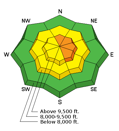
The upper elevation north through southeast facing steep terrain remains dangerous with a CONSIDERABLE avalanche danger. Human triggered avalanches are again likely today in this terrain. Use careful routes and avoid the terrain described above. There is plenty of terrain out there in the mid elevations with excellent snow conditions and is also safe. Keep your slope angles under 35 degrees to avoid triggering an avalanche.
Low
Moderate
Considerable
High
Extreme
Learn how to read the forecast here
Special Announcements

AIR BAGS!!! We've had a lot of questions recently so CLICK HERE FOR A BUNCH OF GREAT INFO!

Weather and Snow

No huge change in conditions from Wednesday. Southerly facing slopes became damp but thin clouds kept the sun from heating the snow to the point of serious instability. Slabs over weak snow near the ground are settling and becoming more stubborn but are still unpredictable.

Ad
Additional Information

General Announcements

We will publish full detailed advisories Saturday and Sunday mornings by 7am. We will also be publishing basic avalanche danger ratings & info during the week.

If you are getting out into the mountains, we love to hear from you! You can SUBMIT OBSERVATIONS ONLINE or EMAIL US

If you would like to have avalanche advisories emailed to you, SIGN UP HERE

We can provide basic avalanche awareness presentations for your school, group or club. To enquire, CLICK HERE