

Forecast for the Skyline Area Mountains

Saturday morning, January 23, 2016
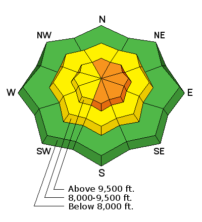
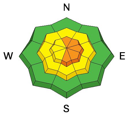
Areas with a CONSIDERABLE danger still exist in the more east facing steep wind drifted slopes in the higher terrain. To avoid getting caught, choose slopes that are less steep than 35 degrees and don't have obvious signs of wind loaded snow. The avalanche danger is much less outside of the wind affected terrain.
 Weather and Snow
Skies are mostly clear this morning and temperatures remain fairly mild in the high country with most stations at around 30. After a day of fairly light wind on Friday, speeds have bumped a bit. We're seeing gusts near 20 so nothing too outrageous. Riding conditions remain excellent in the mid elevation terrain. You will find a melt-freeze crust on some of the sunnier slopes from yesterday's mild temperatures.
 Recent Avalanches
No new activity was reported from Friday. However, there have been a number of human triggered avalanches earlier this week and a few natural avalanches also. Wind loading was the main contributor but they were failing on weak faceted snow deep in the snowpack. Two of them broke to the ground.
| Date | Region | Place | Trigger | Depth | Width | Aspect | Elevation | Weakness | |
|---|---|---|---|---|---|---|---|---|---|
| 01/21/2016 | Skyline | Jollys Hole | Snowmobiler | 4' | Northeast | 10200 | Facets | Details | |
| 01/21/2016 | Skyline | Niotche Creek | 4' | 200 | Northeast | 9800 | Details | ||
| 01/20/2016 | Skyline | Chute Camp Site | Natural | 2.5' | 125 | Northeast | 8500 | Facets | Details |
| 01/18/2016 | Skyline | Rolfson | Snowmobiler | Northeast | 9800 | Facets | Details |

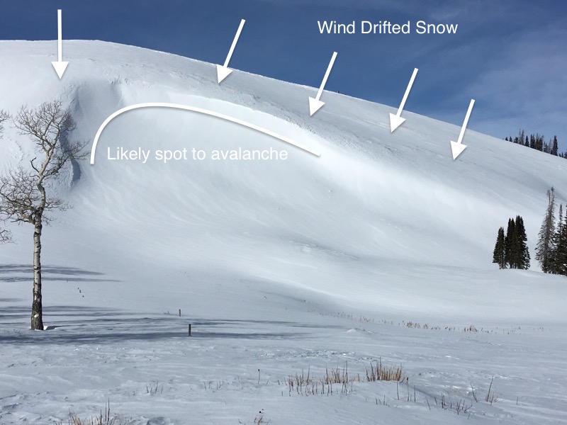
Wind Drifted Snow
Description
Your biggest concern today is the wind drifted snow from earlier this week. The wind has moved snow around making the pattern very complex. Some areas have not seen any wind affect. Some have huge new pillows. Some are in between. Some have loaded slopes that hold old weak faceted snow deep in the snowpack. The newer drifts are becoming more stubborn as time goes on so some won't release if you get onto them. Some still will release. The most recognizable pattern is that the slopes that are more prone to avalanching are on the more eastern side of the compass where the wind has deposited the snow.
Link to video observation: Skyline 20160122 from Brett Kobernik on Vimeo.
Additional Information
A storm is moving in and we'll see increasing clouds and the chance for snow as the day goes on. Wind will be from the southwest and should increase in speed. High temperatures will be around freezing. Most of the snow will fall tonight and I'm thinking we're looking at 4 to 6 inches. The wind will shift northwest and might be a bit gusty. The storm will linger into Sunday and taper off Sunday afternoon. Temperatures will be in the low 20s on Sunday.
General Announcements
We will publish full detailed advisories Saturday and Sunday mornings by 7am. We will also be publishing basic avalanche danger ratings & info during the week.
If you are getting out into the mountains, we love to hear from you! You can SUBMIT OBSERVATIONS ONLINE or EMAIL US
If you would like to have avalanche advisories emailed to you, SIGN UP HERE
We can provide basic avalanche awareness presentations for your school, group or club. To enquire, CLICK HERE