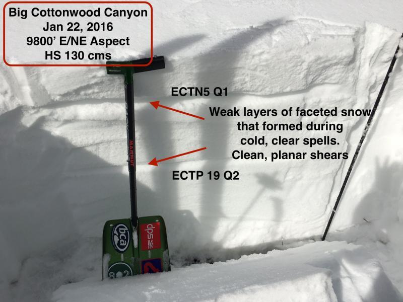
Composite observation from the past two mornings touring in mid Big Cottonwood Canyon. On non-solar aspects, am finding two primary weak layers in the top meter of snow: (1) NSF & SH layer that formed on the surface of the MLK storm. Now 20-30 cms down. Clean, planar shears with shovel tilt test. ECTN5 STE. Not a big concern in wind-sheltered areas as there is not much of a slab on top, but it seems yet another faceted layer we'll have to watch. (2) Layer of NSF that formed Jan 10/11/12. I've been watching this layer over the past 10 days and it does seem to be gaining strength and has compressed somewhat. But as Mark Staples has pointed out very well - even though a layer isn't especially weak, all it needs to be is weaker than the layer above to avalanche. ECTP18 Q2 on this layer.
We did get a full propagation with ECT on the basal facets at 24 taps. But the grains were 4F and damp, and it could have been the column fell over rather than collapsed.
Did travel into some wind affected terrain and still getting cracking in wind drifts that formed on Wednesday, These drifts are sitting on top of weaker, faceted snow so they often can be sensitive for several days.
Did not look at slopes that slid during Christmas/Solstice cycle, but unless you really know the history or it very recently slid, it is really hard to look at a slope and determine if it slid or not. Good rule of thumb: If it is (a) steep, and (b) faces Northwest through East, there is a good chance it slid right before Christmas and has a very weak snowpack with good chance of being a repeater.
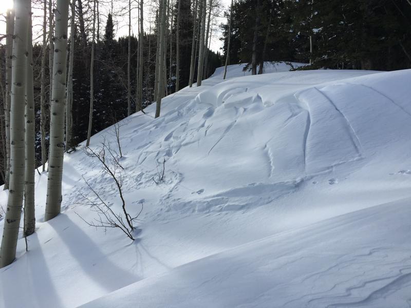
This photo shows stress and spider webbed fractures along an East-facing ridgeline at 10000'. This likely occurred during the day on Wednesday. The slope quickly becomes lower-angled so the avalanche did not run, but this is yet another sign of just how touchy things were on Wednesday.
Very complicated snowpack right now:
- On south aspects there has been wind loading from Wednesday, as well as several crusts with facets between.
- On slopes that slid during the Christmas cycle, the snowpack is very weak and it seems that most avalanche activity this January has been repeaters on these slide paths.
- On slopes that face West through East that did not slide, there are several weak layers with faceted grains sandwiching denser snow. These slopes may not be as touchy as they were a few days ago, but persistent weaknesses stick around awhile, and these weak layers are likely to show their hand with any new loading. I'd be particularly cautious on slopes that have any Easterly component to them, especially at upper elevations.
We can't outsmart the snowpack, and things are less touchy than 2 days ago, but sticking to conservative terrain is really the only strategy for safely traveling in the mountains right now. Fortunately there is good coverage on all aspects and elevations, so there is plenty to choose from.
Sorry to hear of the tragic accident on Gobblers Knob. My thoughts go out to Doug Green, his family and friends.