

Forecast for the Skyline Area Mountains

Thursday morning, January 21, 2016
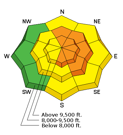
HUMAN TRIGGERED AVALANCHES ARE LIKELY TODAY IN THE MID AND UPPER ELEVATION STEEP MORE EAST FACING TERRAIN. The avalanche danger is CONSIDERABLE in this terrain. Avoid getting onto steep slopes especially in the upper bowls.
Avalanche Warning
We have issued an AVALANCHE WARNING for today. Recent strong winds have transported lots of snow forming fresh drifts and slabs. Human triggered avalanches are very likely today. Avoid travel on and below steep terrain particularly the upper elevation more east facing slopes.
 Weather and Snow
Around 4" of new snow fell on Wednesday. Strong wind on Wednesday was transporting snow at higher elevations as well as getting down into the mid elevations.
 Recent Avalanches
At least one natural avalanche released in Huntington Canyon on Wednesday. DETAILS HERE. This is a very shallow snowpack area which has lots of weak snow still near the ground as well as in the mid portion of the pack. Wind transported snow contributed to this avalanche.

Additional Information
General Announcements
We will publish full detailed advisories Saturday and Sunday mornings by 7am. We will also be publishing basic avalanche danger ratings & info during the week.
If you are getting out into the mountains, we love to hear from you! You can SUBMIT OBSERVATIONS ONLINE or EMAIL US
If you would like to have avalanche advisories emailed to you, SIGN UP HERE
We can provide basic avalanche awareness presentations for your school, group or club. To enquire, CLICK HERE