
Forecast for the Skyline Area Mountains

Tuesday morning, January 19, 2016
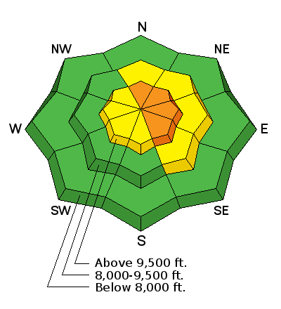
Continued ridgetop wind coupled with new snow overnight dictates a CONSIDERABLE danger along the very steep upper elevation more east facing terrain. Look for any recent natural avalanches and watch for cracking on the snow surface. Use small test slopes to see how sensitive the new wind drifts are. Out of terrain affected by the wind the avalanche danger is LOW to MODERATE.
 Recent Avalanches
Cade Beck stumbled onto an avalanche that looks to have been triggered by a snowmobiler in upper Rolfson Canyon either on late Sunday or Monday some time. It broke into old snow near the ground. Recent wind loading may have been a big contributor to this avalanche. Check the details below:
| Date | Region | Place | Trigger | Depth | Width | Aspect | Elevation | Weakness | |
|---|---|---|---|---|---|---|---|---|---|
| 01/18/2016 | Skyline | Rolfson | Snowmobiler | Northeast | 9800 | Facets | Details |

Additional Information
General Announcements
We will publish full detailed advisories Saturday and Sunday mornings by 7am. We will also be publishing basic avalanche danger ratings & info during the week.
If you are getting out into the mountains, we love to hear from you! You can SUBMIT OBSERVATIONS ONLINE or EMAIL US
If you would like to have avalanche advisories emailed to you, SIGN UP HERE
We can provide basic avalanche awareness presentations for your school, group or club. To enquire, CLICK HERE