

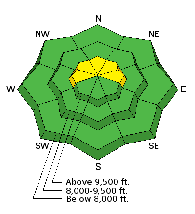
Forecast for the Skyline Area Mountains

Thursday morning, January 14, 2016
The overall avalanche danger is MODERATE today. Diligently look for fresh drifts on a variety of aspects especially around ridges and terrain features. Human triggered avalanches are likely but probably won't be all that large. THE AVALANCHE DANGER WILL INCREASE AS WE ADD MORE NEW SNOW TONIGHT AND INTO FRIDAY.
 Weather and Snow
We have enjoyed a period of fairly stable snow recently. There is enough weak snow around on the surface as well as deeper in the pack that we'll need to notch things back a bit as the next series of storms roll through. For more detailed thoughts check out my Forecast Addendum: Jan 14, 2016 - Weak layer outlook

Additional Information
General Announcements
We will publish full detailed advisories Saturday and Sunday mornings by 7am. We will also be publishing basic avalanche danger ratings & info during the week.
If you are getting out into the mountains, we love to hear from you! You can SUBMIT OBSERVATIONS ONLINE or EMAIL US
If you would like to have avalanche advisories emailed to you, SIGN UP HERE
We can provide basic avalanche awareness presentations for your school, group or club. To enquire, CLICK HERE