Forecast for the Moab Area Mountains

Eric Trenbeath
Issued by Eric Trenbeath on
Saturday morning, January 9, 2016

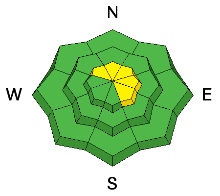
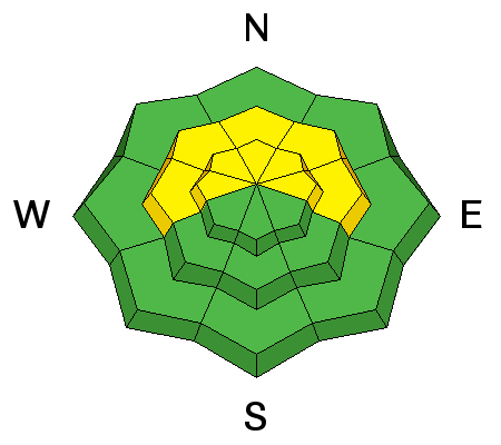
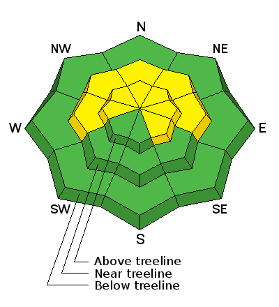
The avalanche danger is MODERATE on mid and upper elevation slopes steeper than 35 degrees that face W-N-E, and in areas where you can detect recent deposits of wind drifted snow.

Low
Moderate
Considerable
High
Extreme
Learn how to read the forecast here
Special Announcements

This is advisory is being updated at 5:00 p.m. to announce that the road to Geyser Pass is officially open. Thanks to the USFS Manti- La Sal Moab / Monticello Ranger District for partnering with Le Grand Johnson and Grand County to make this happen.

The Utah Avalanche Center-Moab will be hosting an Avalanche 101 class on January 15,16. This course is generously sponsored by Moab Gear Trader and will consist of an evening classroom session and a day out in the field. This course will cover avalanche characteristics and snowpack fundamentals, clues to instability, assessment of avalanche terrain, route finding and companion rescue. For more information, see the link below or contact me at [email protected].

https://utahavalanchecenter.org/classes/moab-backcountry-101

Weather and Snow

The mountains picked up about about a foot of snow between Tuesday and Friday this week and winds have remained remarkably calm. Conditions should be still be excellent up there, so get up and enjoy it before high pressure sets in this week.

Winds, temperature and humidity on Pre-Laurel Peak

New snow totals, temperature and humidity in Gold Basin

Total snow depth and temperature at Geyser Pass Trailhead

Another gorgeous day on Laurel Ridge.

Ad
Avalanche Problem #1
Wind Drifted Snow
Type
Location
Likelihood
Size
Description

On Thursday we observed drifts up to 18" deep along upper elevation ridge crests, but they lacked cohesion and would only crack right at your skis and then break apart. Slope cuts through drifted areas produced no results. Nevertheless, they were out there, there is plenty of loose snow available for transport, and winds occasionally spiked to 20 mph over the past two days, so I'm going to leave this warning up until I get a chance to look around up there tomorrow. As always, suspect smooth deposits of wind drifted snow, and test them with a slope cut when you can do so safely.


Drifted snow Thursday lacked cohesion, but slight increases in wind over the past couple of days may have contributed to further wind slab development.

Avalanche Problem #2
Persistent Weak Layer
Type
Location
Likelihood
Size
Description

The snow pack is gaining strength and it appears as though some of our mid level faceted layers are gaining strength. Weaknesses still exist on slopes that face W-N- E, but the greatest danger exist on northeasterly facing terrain, in areas that still have a shallow and weak snowpack. In these areas it may be possible to trigger a full depth, deep slab avalanche. Particular caution needs to be given to areas of steep, rocky, and more radical terrain, or those areas on the periphery of slopes where pockets of trees or rock outcroppings can create shallower pockets or "trigger points" for releasing an avalanche. Mind your p's and q's and carefully analyze slopes steeper than 35 degrees that face the north half of the compass.

We dug this pit in the Funnel yesterday. Compression tests produced no results on mid level faceted layers. Failure on facets beneath a crust at 30 centimeters occurred with significant effort. For snow geeks, the score was CT 23 Q 3.

Additional Information

Tonight

A 10 percent chance of snow before 9pm. Mostly cloudy, with a low around 8. West northwest wind 5 to 10 mph.

Sunday

A 20 percent chance of snow. Partly sunny, with a high near 13. Calm wind becoming north northwest around 5 mph in the afternoon.

Sunday Night

A 10 percent chance of snow before 8pm. Partly cloudy, with a low around 4. North wind around 5 mph.

Monday

Mostly sunny, with a high near 15. North wind around 5 mph.

Monday Night

Mostly clear, with a low around 7.

Tuesday

Sunny, with a high near 18.

General Announcements

Grooming: Matt was able to get up with the plow crews today, and he groomed Gold Basin and packed out over Geyser Pass.

Thanks for sending in your observations. You can view Moab observations here. To post an observation go here.

To receive this advisory by email go here.

This information does not apply to developed ski areas or highways where avalanche control is normally done. This advisory is from the U.S.D.A. Forest Service, which is solely responsible for its content. This advisory describes general avalanche conditions and local variations always exist.