


Forecast for the Skyline Area Mountains

Tuesday morning, January 5, 2016
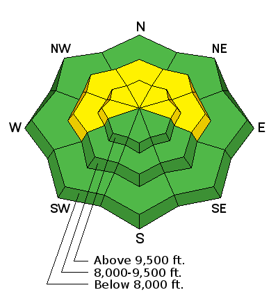
The avalanche danger remains MODERATE in the mid and upper elevation west through north through east facing terrain. I am still avoiding steeper slopes along the higher terrain especially that face west, northwest and north as these have received the most drifted snow from the last few days. Human triggered avalanches are possible and some of these could break into old weak sugary snow near the ground creating a dangerous avalanche.
THE AVALANCHE DANGER MAY INCREASE MID WEEK DEPENDING ON HOW MUCH SNOW AND WIND THE NEXT STORM DELIVERS.
 Weather and Snow
Southeast wind continued to blow pretty hard on Monday. The upper elevations look like a moonscape with stout rippled snow and large pillows scattered about. All this east wind has really mixed things up in the higher terrain making avalanche assessment quite difficult.

Additional Information
General Announcements
We will publish full detailed advisories Saturday and Sunday mornings by 7am. We will also be publishing basic avalanche danger ratings & info during the week.
If you are getting out into the mountains, we love to hear from you! You can SUBMIT OBSERVATIONS ONLINE or EMAIL US
If you would like to have avalanche advisories emailed to you, SIGN UP HERE
We can provide basic avalanche awareness presentations for your school, group or club. To enquire, CLICK HERE