Forecast for the Moab Area Mountains

Eric Trenbeath
Issued by Eric Trenbeath for
Sunday, December 27, 2015
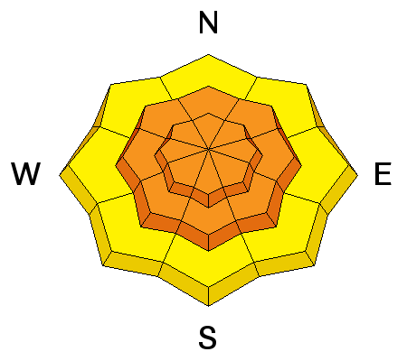
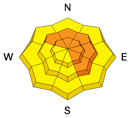
The avalanche danger is CONSIDERABLE​ today on any slope steeper than 35 degrees where you can detect recent deposits of wind drifted snow. There is also a CONSIDERABLE danger for deeper, persistent slab avalanches on slopes steeper than 35 degrees that face NW-NE-SE. Stick to lower angle terrain today and stay out from under avalanche run out zones.

Low
Moderate
Considerable
High
Extreme
Learn how to read the forecast here
Special Announcements

Access to the Geyser Pass Trailhead is challenging. Plow crews have not been up since Thursday and strong winds and more than a foot of snow has created deep drifts across the road. Several vehicles were able to punch through Friday and yesterday, but 4wd and chains are a must, and even then, access is not guaranteed.

Weather and Snow

Northeast winds were nuking yesterday. Picking up around 7:00 am. they averaged 30 mph with gusts as high as 60, and only gradually tapered off around 1:00 a.m. this morning. This is a rather unfortunate turn after the 15-20" of new, low density powder snow that fell the day before. Expect to find areas of deep drifted snow and alternating scoured zones out there today with only the most sheltered areas spared. ENE winds are currently blowing in the 15-20 mph range and it's 15 degrees on Pre Laurel Peak, 4 in Gold Basin.

Winds, temperature and humidity on Pre-Laurel Peak

New snow totals, temperature and humidity in Gold Basin

Total snow depth and temperature at Geyser Pass Trailhead

Ad
Avalanche Problem #1
Wind Drifted Snow
Type
Location
Likelihood
Size
Description

Very strong NE winds with lots of snow available for transport have created widespread areas of wind drifted snow. Expect to find wind slabs on the lee sides of nearly every terrain feature you encounter. Cross loading will be significant, even on slopes that appear to be windward, and you may encounter fresh wind slabs adjacent to areas of bare ground. Suspect any smooth, rounded pillow of recently deposited wind drifted snow, and look for signs such as cracking or collapsing of the snowpack. Avoid slopes steeper than 35 degrees on all aspects today in areas where you can detect recent deposits of wind drifted snow.

Avalanche Problem #2
Persistent Weak Layer
Type
Location
Likelihood
Size
Description

Snow and winds of the past week have significantly increased the load on top of buried persistent weak layers in the snowpack. With this latest round, the possibility for triggering a deep, and dangerous persistent slab avalanche is very real. For the immediate future, give slopes that haven't run a wide berth and avoid slopes steeper than 35 degrees that face NW-NE-SE.

Additional Information

Today

Sunny and cold, with a high near 9. Wind chill values as low as -20. Northeast wind 5 to 10 mph becoming south southeast in the afternoon.

Tonight

Partly cloudy, with a low around 1. Wind chill values as low as -10. South southwest wind 5 to 10 mph.

Monday

Mostly sunny, with a high near 19. Wind chill values as low as -15. South southwest wind 5 to 10 mph.

Monday Night

A 20 percent chance of snow after 11pm. Mostly cloudy, with a low around 2. South southwest wind 10 to 15 mph.

Tuesday

A 40 percent chance of snow. Mostly cloudy and cold, with a high near 5. Northwest wind around 10 mph.

Tuesday Night

A 20 percent chance of snow. Mostly cloudy, with a low around -3.

Wednesday

A 20 percent chance of snow. Mostly sunny and cold, with a high near 4.

General Announcements

Thanks for sending in your observations. You can view Moab observations here. To post an observation go here.

To receive this advisory by email go here.

This information does not apply to developed ski areas or highways where avalanche control is normally done. This advisory is from the U.S.D.A. Forest Service, which is solely responsible for its content. This advisory describes general avalanche conditions and local variations always exist.