UDOT PLANNED AVALANCHE CLOSURES!!

Observation: Cardiff Fork

Observation Date
12/26/2015
Observer Name
Kikkert
Region
Salt Lake » Big Cottonwood Canyon » Cardiff Fork
Location Name or Route
Cardiff Fork
Weather
Sky
Few
Wind Direction
North
Wind Speed
Light
Weather Comments
One of those cold, but beautiful mornings after a storm. Temperatures below zero, but not too bad out of the wind. Winds were light, 5-10 mph from the north along ridge lines only, but even that light breeze made it considerably colder on the ridge. Even though the winds were light where we were, you could see they were stronger along the BCC/LCC ridgeline near Cardiff Peak and Cardiac Bowl, with some snow moving around. Classic loading pattern for places like south face of Little Superior.
Snow Characteristics
Snow Surface Conditions
Powder
Snow Characteristics Comments

No new overnight, obviously tons since the start of the storm. Total snow depth above 9,000' averaged around 160 cm.

Red Flags
Red Flags
Recent Avalanches
Heavy Snowfall
Cracking
Collapsing
Poor Snowpack Structure
Red Flags Comments
Recent natural noted in Mineral Fork (see separate avalanche) and one large collapse near the ridgeline.
Avalanche Problem #1
Problem
Persistent Weak Layer
Problem #1 Comments

The faceted snow from before the storm is now buried over a meter deep in most places I looked above approx. 9,000', with the total new snow from the storm forming a thick right side up slab, going from near pencil hardness at the bottom to fist hardness at the surface. Because the weak layer is now so deep and the slab near the bottom nearing pencil hardness, its going to be considerably more difficult to trigger one of these monsters. However, the classic low probability high consequence scenario was very well illustrated in this area as follows: 1) dug a pit near the top of the ridgeline in George's Bowl and found a deep snowpack (180 cm deep) and was unable to affect the weak layer in any stability tests, this leads one to thinking that stability is good; 2) I walked 50 feet above the pit and collapsed the whole slope while crossing a thinner rocky portion of the slope (low angle so didn't slide, but would have if steeper); walked another 50 feet and could see the natural in Mineral on a similar aspect. This fits into the pattern I saw around Brighton Christmas Eve, where most natural activity was in rocky areas. Danger rating will gradually decrease from considerable to a scary moderate, but its all the same to me, with patience the key for a while yet.

FORECASTER COMMENTS: Again, another excellent observation from Dave Kikkert.
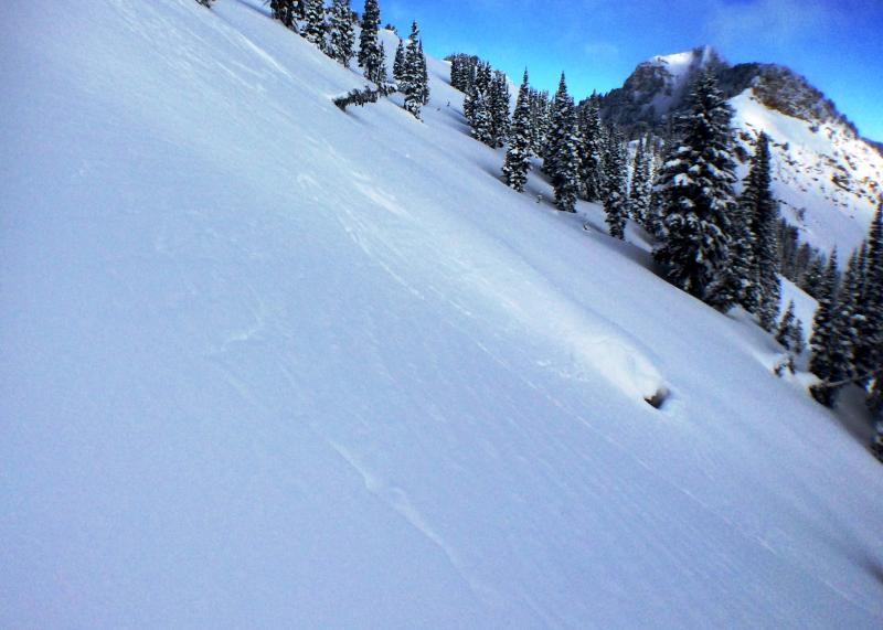
Kind of hard to see, but photo shows some cool cracks that were present in multiple areas where the slope had collapsed but not slid (due to lower slope angle).

Today's Observed Danger Rating
Considerable
Tomorrows Estimated Danger Rating
Moderate