

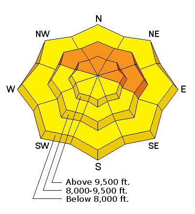
Forecast for the Salt Lake Area Mountains

Friday morning, December 18, 2015
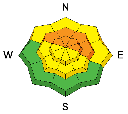
The avalanche danger is CONSIDERABLE on upper and mid elevation slopes facing northwest through easterly and steeper than about 30 degrees. Human triggered slides are likely, and can be triggered remotely from a distance. Other steep slopes have a MODERATE danger of triggering new snow slides, wind drifts or wet sluffs.
Low angle terrain is the place to recreate in the backcountry -whether you are riding, turning, snowshoeing or sledding.
 Special Announcements
Deer Valley Empire area is closed to uphill traffic, as they will be doing explosive work.
Buy discount lift tickets to Utah resorts and benefit the Utah Avalanche Center! Details here
 Weather and Snow
It is downright balmy out, with temperatures an astonishing 20 degrees warmer than yesterday morning. Most stations are in the 20s, and the southwesterly winds are light, less than 20 mph. In parts of the Salt Lake mountains, it’s precipitating a mix of frozen rain and rime, crusting the snow surface. Elsewhere, the snow has settled, and been thickened by the wind on many aspects and even crusted a bit on the steeper sunny slopes.
 Recent Avalanches
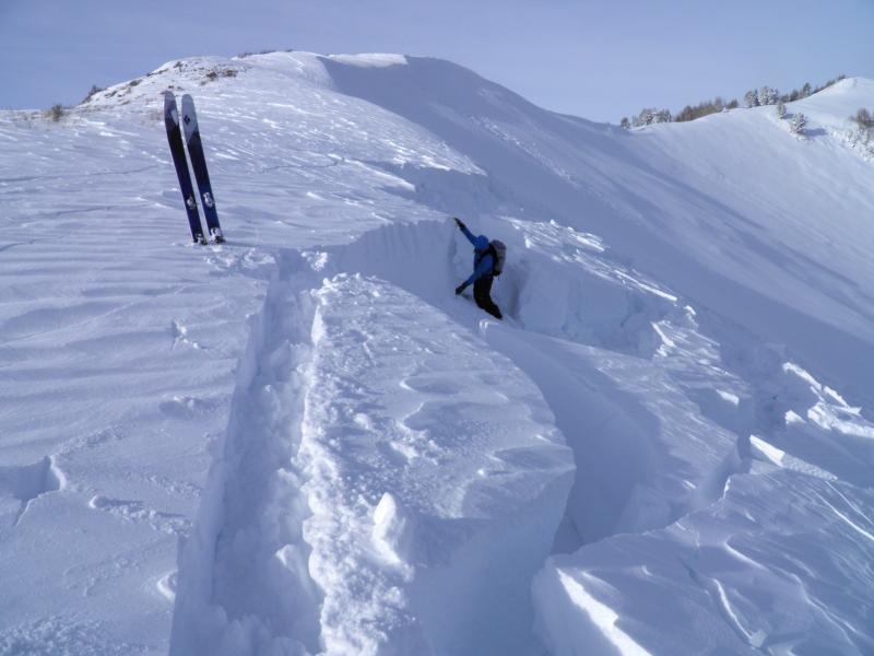
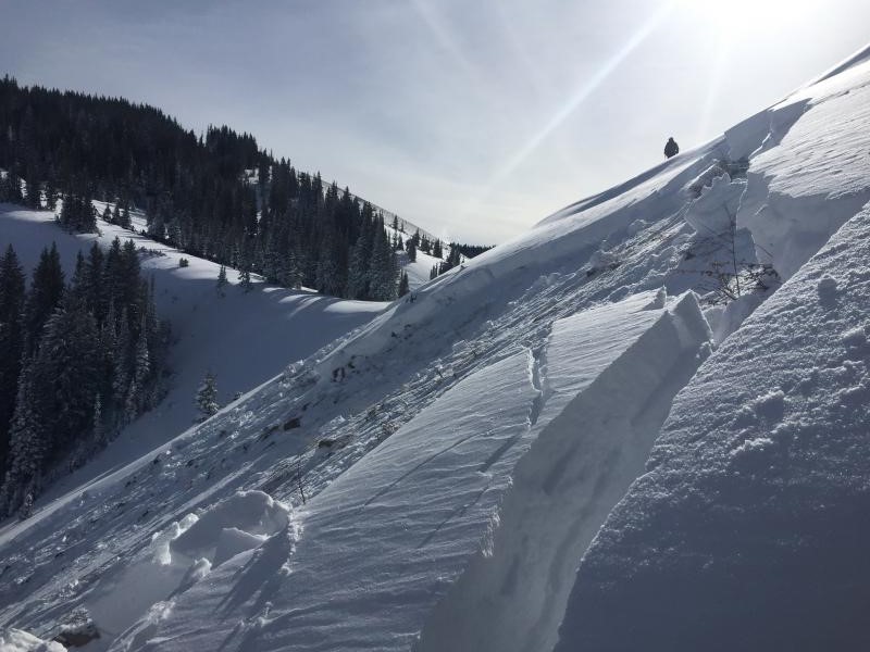
The Park City ridge line basically came unglued - naturals occurred overnight and midday in Dutch Draw, and slides were remotely triggered in No Name, Scotts, Radar Love and South Monitor (1000' wide by 4’ deep), all failing on facets near the ground. Isolated naturals occurring during the storm included south face of Superior, on Gobblers, the White Pine slide path, and in the Milly and Brighton Basins.
Ski area avalanche reduction work in Little and Big Cottonwood released medium to large slab avalanches on all aspects above 9,000’, with the focus on northwest, north and northeasterly facing slopes.
Left: South Monitor slide, Mark White photo Right: Scotts Bowl, Grant photo
| Date | Region | Place | Trigger | Depth | Width | Aspect | Elevation | Weakness | |
|---|---|---|---|---|---|---|---|---|---|
| 12/17/2015 | Salt Lake | Dutch Draw | Natural | 2.5' | 200 | Northeast | 9800 | Depth Hoar | Details |
| 12/17/2015 | Salt Lake | Radar Love Bowl | Skier | 3' | 100 | Northeast | 9700 | Facets | Details |
| 12/17/2015 | Salt Lake | South Monitor Bowl | Skier | 4' | 1000 | Northeast | 9900 | Facets | Details |
| 12/17/2015 | Salt Lake | Scotts Bowl | Snowboarder | 3.5' | 200 | Northeast | 9500 | Facets | Details |
| 12/17/2015 | Salt Lake | No Name Bowl | Skier | 2' | 125 | Northeast | 9300 | Facets | Details |
| 12/17/2015 | Salt Lake | Mill A | Natural | unknown | Unknown | Northeast | 9600 | Facets | Details |
Persistent Weak Layer
Description
While there were some spectacular avalanches yesterday, unfortunately most slopes were left hanging once again. It’s a dangerous situation, as so many of the tempting slopes that didn’t slide could be triggered by a person. The steep slopes facing northwest through north through east are NOT the place to be – any slide triggered will break to the ground and go full track. Slides can be triggered from a distance or from below, and tracks on a slope are not a sign of stability. If you hear a collapsing or whoomphing sound, you are in the danger zone - get off of and out from under steep slopes.
Wet Snow
Description
Rapid warming today may trigger wet sluffs at the lower elevations and on a few steep sunny slopes if the skies clear. Roofs may start to shed their snow in both the valleys and mountain towns, resulting in piles of snow deep enough to bury a person.
Additional Information
Once the rain/rime stops, it should be a pleasant break today, with gradually clearing skies and very warm temperatures – highs near 40 degrees at 8,000’ and near 30 at 10,000’. The southwesterly winds will remain moderate, averaging 15 to 25 mph, gusting in the 30s, with the highest peaks averaging to 35 mph. Overnight, the winds will ramp up ahead of the next storm that could give us a descent shot of snow Saturday night. Next week continues to look very stormy - warm, windy and wet, with periods of heavy snowfall.
General Announcements
|
Remember your information can save lives. If you see anything we should know about, please participate in the creation of our own community avalanche advisory by submitting snow and avalanche conditions. You can also call us at 801-524-5304, email by clicking HERE, or include #utavy in your tweet or Instagram. To get help in an emergency (to launch a rescue) in the Wasatch, call 911. Be prepared to give your GPS coordinates or the run name. Dispatchers have a copy of the Wasatch Backcountry Ski map. If you trigger an avalanche in the backcountry, but no one is hurt and you do not need assistance, please notify the nearest ski area dispatch to avoid a needless response by rescue teams. Thanks. Salt Lake and Park City – Alta Central (801-742-2033), Canyons Resort/PCMR Dispatch (435)615-1911 Snowbasin Resort Dispatch (801-620-1017), Powder Mountain Dispatch (801-745-3772 x 123). Sundance Dispatch (801-223-4150) EMAIL ADVISORY If you would like to get the daily advisory by email you will need to subscribe here. DAWN PATROL Hotline updated daily by 5-530am - 888-999-4019 option 8. Twitter Updates for your mobile phone - DETAILS UDOT canyon closures: LINK TO UDOT, or on Twitter, follow @UDOTavy, @CanyonAlerts or @AltaCentral Utah Avalanche Center mobile app - Get your advisory on your iPhone along with great navigation and rescue tools. Wasatch Powderbird Guides Blog/Itinerary for the Day. Lost or Found something in the backcountry? - http://nolofo.com/ To those skinning uphill at resorts: it is your responsibility to know the resort policy on uphill travel. You can see the uphill travel policy for each resort here. IMPORTANT: Before skinning or hiking at a resort under new snow conditions, check in with Ski Patrol. Resorts can restrict or cut off access if incompatible with control and grooming operations. Benefit the Utah Avalanche Center when you shop from Backcountry.com or REI: Click this link for Backcountry.com or this link to REI, shop, and they will donate a percent of your purchase price to the UAC. Both offer free shipping (with some conditions) so this costs you nothing! Benefit the Utah Avalanche Center when you buy or sell on ebay - set the Utah Avalanche Center as a favorite non-profit in your ebay account here and click on ebay gives when you buy or sell. You can choose to have your seller fees donated to the UAC, which doesn't cost you a penny. This information does not apply to developed ski areas or highways where avalanche control is normally done. This advisory is from the U.S.D.A. Forest Service, which is solely responsible for its content. This advisory describes general avalanche conditions and local variations always exist. |