Observation Date
12/17/2015
Observer Name
Cawley
Region
Salt Lake » Little Cottonwood Canyon » Emma Ridges
Location Name or Route
Flagstaff-Emma 2
Weather
Sky
Few
Wind Direction
Northwest
Wind Speed
Calm
Weather Comments
Obvious transport @ 900 AM mostly ceased by ~11, dead calm in the PM.
Snow Characteristics
New Snow Depth
2.5'
New Snow Density
Low
Snow Surface Conditions
Dense Loose
Damp
Snow Characteristics Comments
Today's new snow bears some wind-effect, and most southerlies took on enough solar during the day to become damp and, perhaps on S & SW-facing, there could be some crusts tomorrow. Certainly felt very different than the last couple days of very light density snow, and it has generally settled out to what feels like about 2.5 feet deep in the places where i traveled. Overnight snow had settled into yesterday's ski/skin tracks on some southerlies by the PM, with injury from collision with the Emma 2 skin track more likely than from hitting rocks. Kind of a mixed bag, actually.
Red Flags
Red Flags
Recent Avalanches
Heavy Snowfall
Wind Loading
Poor Snowpack Structure
Red Flags Comments
Heavy snowfall and wind loading had ceased by the time I was heading up; more on recent avalanches below.
Avalanche Problem #1
Problem
Persistent Weak Layer
Trend
Same
Problem #1 Comments
Kind of disappointing observing today, with a few relatively pockety avalanches in steep, rocky E-NE facing terrain the only indication that our weak snow has had enough. No significant avalanches were observed in Upper Days Fork, and no cracking/collapsing was noticed as my party of 5 traversed toward Silver Fork. I have not been on any northerly slopes lately but I assume shady slopes are primed for human-triggered, deep slab avalanches.
Avalanche Problem #2
Problem
New Snow
Trend
Decreasing Danger
Problem #2 Comments
Substantial overnight transport of snow from 12.14-12/17 formed deep, pockety drifts along the flagstaff ridgeline, seemingly isolated to the ridgeline itself. Some small new snow slides were observed in steep rocky areas which appeared to have run during last nights storm. I'm sure there's a place where a human-triggered release within the new snow was possible today, although settlement felt significant during the day today on the most sun-exposed slopes.
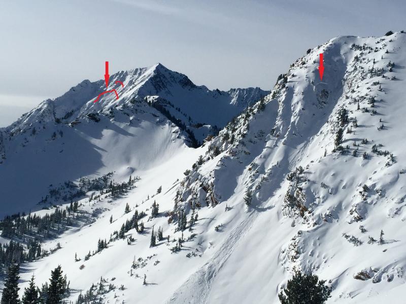
Photo shows the only two significant backcountry avalanches visible on my travels today; an explosive triggered pocket in a NE facing, steep, rocky portion of Toledo Chute; and in the distance, last night's natural from ~E facing Mt. Superior. I did my best to indicate where the visible fractures are on Superior. It's a pretty interesting slide; bigger-looking slides on superior sometimes stop well short of the willows, but perhaps the light density snow was easily entrained by the initial release.
Today's Observed Danger Rating
Considerable
Tomorrows Estimated Danger Rating
Considerable