Forecast for the Skyline Area Mountains

Brett Kobernik
Issued by Brett Kobernik for
Saturday, December 12, 2015

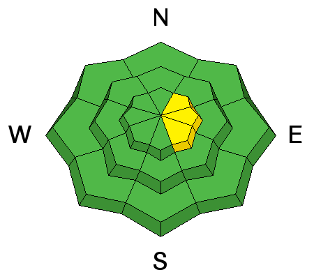
The avalanche danger will most likely rise to MODERATE along the higher easterly facing steep terrain today. Watch for drifting snow and avoid fresh wind pillows. Aside from the higher more exposed terrain, most of the mountain terrain has a LOW avalanche danger.
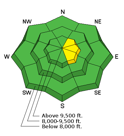
Low
Moderate
Considerable
High
Extreme
Learn how to read the forecast here
Weather and Snow

5 or 6 inches of low density powder snow fell overnight on Thursday night and just a skiff more overnight last night. Winds were cranking pretty good before the storm but calmed right down during the snowfall. This left a very evenly distributed layer of low density snow which did not increase the avalanche danger on Friday like I anticipated. Temperatures are in the mid teens this morning with fairly light north northwest winds.

Ad
Avalanche Problem #1
Wind Drifted Snow
Type
Location
Likelihood
Size
Description

The wind today will be the wild card. It is expected to increase in speed from the north northwest as the day goes on. If this happens it is sure to drift around the newest low density snow that's on the surface. This will most likely create some drifts and wind slabs that will probably be sensitive to the weight of a person. There is plenty of weak faceted sugary snow that these new drifts will be forming on top of. Watch for cracking and pay attention to any collapsing or "whumpfing" sounds you may experience. This is a sure sign that you are in an area that has unstable snow.

General Announcements

We will publish full detailed advisories Saturday and Sunday mornings by 7am. We will also be publishing basic avalanche danger ratings & info during the week.

If you are getting out into the mountains, we love to hear from you! You can SUBMIT OBSERVATIONS ONLINE or EMAIL US

If you would like to have avalanche advisories emailed to you, SIGN UP HERE

We can provide basic avalanche awareness presentations for your school, group or club. To enquire, CLICK HERE