Forecast for the Moab Area Mountains

Eric Trenbeath
Issued by Eric Trenbeath for
Monday, November 30, 2015

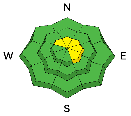
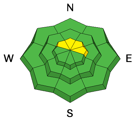
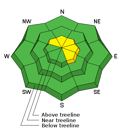
Today there is a MODERATE danger for triggering a recently deposited wind slab along the lee sides of upper elevation ridge crests that face NW-N-NE-SE There also remains a very isolated, or MODERATE danger for triggering a persistent slab on slopes steeper than 35 degrees with a NW-N-E aspect right around tree line and above, in areas of rocky and radical terrain.

Low
Moderate
Considerable
High
Extreme
Learn how to read the forecast here
Weather and Snow

Whoa. Looks we got a bit of a surprise last night. Sensors are reporting 8-10" of light density snow in the mountains this morning. Pre Laurel winds are unavailable until we get another part for the weather station, but winds on Abajo Peak have been mostly well behaved, averaging around 12 mph but gusting to 20 mph. In short, this looks to be a very excellent day up there. It is however, very cold showing 2 degrees at Geyser Pass Trailhead.

Base depth in Gold Basin: 32"

Base depth at Geyser Pass Trailhead: 21"

Winds, temperature and humidity on Pre-Laurel Peak

New snow totals, temperature and humidity in Gold Basin

Total snow depth and temperature at Geyser Pass Trailhead

Ad
Avalanche Problem #1
Wind Drifted Snow
Type
Location
Likelihood
Size
Description

Though winds haven't been too strong, the new snow is quite light density, and there has been just enough wind to move it around. Be on the lookout for freshly deposited wind slabs on the lee sides of ridges and terrain features today. Look primarily on slopes the face NE-E-SE but there may be some cross-loading on NW facing aspects.

Avalanche Problem #2
Persistent Weak Layer
Type
Location
Likelihood
Size
Description

Depth hoar development has accelerated near the ground, and the snow pack is still harboring some weak layers, but stability tests yesterday showed the pack to be mostly stable. It may still be possible to trigger a persistent slab avalanche in the usual suspect areas - steep, rocky slopes that face the north half of the compass, right around and above treeline, and these areas should always be approached with caution, but in general, the identified weaknesses are more of a concern for future snow loads.

Additional Information

Today

A 40 percent chance of snow, mainly before 9am. Mostly sunny and cold, with a high near 10. Wind chill values as low as -10. West southwest wind around 10 mph.

Tonight

Partly cloudy, with a low around 7. West wind 5 to 10 mph.

Tuesday

Sunny, with a high near 16. North northwest wind around 5 mph.

Tuesday Night

Mostly clear, with a low around 10. North wind around 10 mph, with gusts as high as 20 mph.

Wednesday

Sunny, with a high near 25. Northeast wind 10 to 15 mph becoming northwest in the afternoon.

Wednesday Night

Mostly clear, with a low around 13.

Thursday

Sunny, with a high near 25.

Thursday Night

Partly cloudy, with a low around 16.

Friday

Mostly sunny, with a high near 26.

General Announcements

The Road to the Geyser Pass Trailhead will be snow covered this morning.

Thanks for sending in your observations. You can view Moab observations here. To post an observation go here.

To receive this advisory by email go here.

This information does not apply to developed ski areas or highways where avalanche control is normally done. This advisory is from the U.S.D.A. Forest Service, which is solely responsible for its content. This advisory describes general avalanche conditions and local variations always exist.