

Forecast for the Logan Area Mountains

Tuesday morning, March 24, 2015
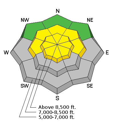
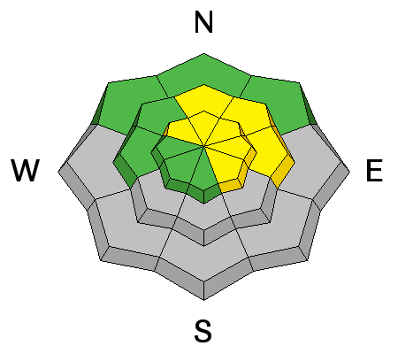
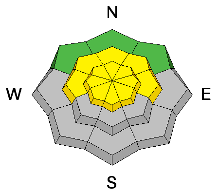
MODERATE (Level 2): Heightened avalanche conditions exist at upper elevations, and wind slab and storm snow avalanches are possible on slopes steeper than about 30 degrees in the backcountry.
- Evaluate the snow and terrain carefully, especially in drifted upper elevation terrain.
- Avoid steep drifted slopes and ridge-top cornices
- Limit travel below steep slopes during periods of rapid warming or rapidly accumulating snowfall.
 Special Announcements
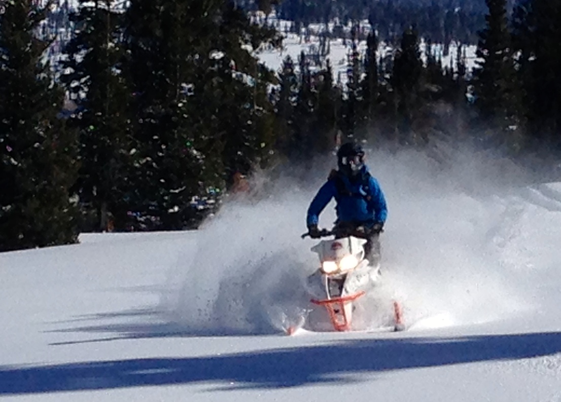
Special thanks to Buttar's of Tremonton and ArcticCat for hooking us up with the light and powerful M8000,
 Weather and Snow
We're likely to see a little more snowfall in the mountains today, and shallow powder conditions should be pretty good. The wet snow beneath yesterday's fresh snow is kind of soft in some areas, but much colder temperatures today and tonight will help solidify things. Our avalanche concerns will be focused on new snow instabilities, with wind slab and storm snow avalanches possible at upper elevations. The Tony Grove Snotel reports around 8 inches of new snow from yesterday and overnight, and 60 inches (exactly 5 feet) of total snow containing 76% of average water for the date. Overnight temperatures were significantly cooler than we've seen for well over a week, with 25 degrees at the 8400' site. It's a refreshing 16 degrees at 9700' CSI Logan Peak, and 23 degrees at the UDOT Hwy 89 Summit weather station, with a good deal of drifting snow and 20 to 30+ mph west-northwest winds overnight.
 Recent Avalanches
Widespread natural loose wet avalanches occurred across the Logan Zone during the heat of the day last week, and riders reported observing a couple more sizable avalanches at upper elevations and on east facing slopes near the state line on Friday.
***Watch "Natural Wet Avalanches up in Tony Grove," an observational video from 3-17-2015.......... HERE
-
***Check out our Backcountry Observations Page for more local and statewide avalanche information...

Persistent Weak Layer
Description
Drifting of the new snow continued at upper elevations overnight, with fairly strong and sustained west-northwest winds. Triggered wind slabs 1 to 2 feet deep failing on the old wet snow interface or within the fresh snow are possible, and some of these could run fast and far on a crusty refrozen and smooth underlying bed surface. Avoid fresh drifts on steep slopes and reformed ridge-top cornices, which might break further back than expected, and could trigger wind slab avalanches on slopes below.
New Snow
Description
- The sun may peek out for a bit this morning, and it could quickly warm the fresh snow. Shallow storm slabs are a possibility and loose wet avalanches involving sticky fresh snow may become likely in some areas.
- Snowfall should resume this afternoon, and natural shallow soft slabs involving new snow may occur on some steep slopes during periods of especially heavy snowfall. Avoid travel under steep terrain during periods with high rates of accumulation.
Additional Information
Snow is likely in the mountains today, with 3 to 7 inches of additional accumulation possible at upper elevations. Expect 20 to 25 mph southwest wind, with gusts near 40 mph and temperatures around freezing on the highest peaks. Snow showers will likely continue into tonight, with another 1 to 3 inches of snow possible, temperatures dropping into the lower twenties, and moderate west winds. Expect partly sunny conditions tomorrow, with mountain high temperatures hovering just above freezing at upper elevations and a moderate northwest breeze.
***Check out our one-stop weather page........HERE
General Announcements
***Advisories by email for the Logan Zone. Go here for details.
Discount lift tickets are now available at Backcountry.com. Thanks to Ski Utah and the Utah Resorts. All proceeds go towards paying for Utah Avalanche Center avalanche and mountain weather advisories.
Benefit the Utah Avalanche Center when you shop from Backcountry.com or REI: Click this link for Backcountry.com or this link to REI, shop, and they will donate a percent of your purchase price to the UAC. Both offer free shipping (with some conditions) so this costs you nothing!
***Please submit snow and avalanche observations from your ventures in the backcountry HERE. You can call us at 801-524-5304 or email HERE, or include #utavy in your Instagram or Tweet us @UAClogan. To report avalanche activity in the Logan Area or to contact the local avalanche forecaster call me, Toby, at 435-757-7578.
As we're rapidly heading into spring, we'll post these advisories intermittently and as conditions change in the backcountry. This advisory is produced by the U.S.D.A. Forest Service, which is solely responsible for its content. It describes only general avalanche conditions and local variations always exist.