Forecast for the Moab Area Mountains

Eric Trenbeath
Issued by Eric Trenbeath for
Friday, January 30, 2015

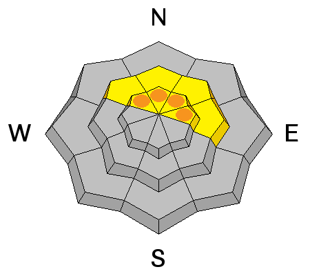
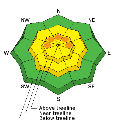
The avalanche danger is MODERATE this morning but could rise to CONSIDERABLE as new snow accumulates throughout the day. This danger applies both to recent deposits of wind drifted snow as well as deep and dangerous persistent slabs. Mountain travelers need to be alert to changing conditions and rising avalanche danger. Avoid slopes steeper than 35 degrees where there are recent deposits of wind drifted snow.

Low
Moderate
Considerable
High
Extreme
Learn how to read the forecast here
Weather and Snow

Snow has begun to fall in the mountains with stations in the La Sal and Abajo Mountains both reporting 2" of snow at 6:00 a.m. I wouldn't run right out there this morning looking for fresh powder as the underlying snow surface is a bit rugged to say the least Look for conditions to improve today with 3-5" of snow in the forecast and possibly 3-5" more tonight. Winds on Pre Laurel Peak have been on the increase overnight, averaging 20 mph with gusting to 30 mph from the SE. They are blowing slightly less on Abajo Peak averaging 15-20 mph. It is currently 21 degrees on Pre Laurel and a balmy 30 at the Geyser Pass Traihead.


La Sal Mountains Current Weather

Wind speeds and temperature at 11,700' on Pre-Laurel Peak.

New snow totals and temperature at Geyser Pass Trailhead.

New snow totals and temperature in Gold Basin.

Abajo / Blue Mountains.

Winds and temperature on Abajo Peak.

Snow total at Buckboard Flat.

Ad
Avalanche Problem #1
New Snow
Type
Location
Likelihood
Size
Description

Timing will be everything today with the danger for new snow avalanches rising commiserate with new snow totals. By mid-day there may be enough accumulation for new snow sluffing on steeper slopes as well as sensitive new wind drifts forming on the lee sides of terrain features in wind exposed terrain. Cross loading will be a factor with the SE winds so watch for developing wind slabs in unusual places. By Saturday morning these new wind slabs, if triggered, could be deep enough to step down into older, very weak snow causing large and dangerous avalanchesthat break to the ground.

Avalanche Problem #2
New Snow
Type
Location
Likelihood
Size
Description

With the weight of new snow being added to our fragile snowpack, the danger for triggering a persistent slab will increase throughout the day. By tomorrow, if snow totals come in on the forecasted high end we could see large and dangerous, natural avalanches breaking to the ground. This danger is most pronounced on upper-mid to upper elevation slopes steeper than 35 degrees that have a NW-N-E aspect, particularly in areas of rocky terrain that have a thin shallow snowpack.

Additional Information

A low pressure system with tropical moisture will bring mountain snow to our area today into Saturday. Today look for 3-5" of new snow with another 3-5" possible tonight. High temperatures today at 10,000' will be around 30 degrees and winds will be out of the SE at 10-15 mph.

General Announcements


Road Conditions: Expect to find snow on the road today and through the weekend.

Grooming Conditions: Trails are scheduled to be groomed on Monday and Friday.

Observations: If you are out and about, I would love to know what you are seeing. Please post your observations here.

EMAIL ADVISORY If you would like to get the daily advisory by email you will need to subscribe here.​

Benefit the Utah Avalanche Center when you shop from Backcountry.com or REI: Click this link for Backcountry.com or this link to REI, shop, and they will donate a percent of your purchase price to the UAC. Both offer free shipping (with some conditions) so this costs you nothing!

Benefit the Utah Avalanche Center when you buy or sell on ebay - set the Utah Avalanche Center as a favorite non-profit in your ebay account here and click on ebay gives when you buy or sell. You can choose to have your seller fees donated to the UAC, which doesn't cost you a penny.

This advisory is from the U.S.D.A. Forest Service, which is solely responsible for its content. This advisory describes general avalanche conditions and local variations always exist. This advisory will be updated on Thursday, January 22.