
Forecast for the Skyline Area Mountains

Saturday morning, January 17, 2015
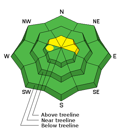
There is a MODERATE avalanche danger for fresh wind drifts along the higher north, northeast and east facing terrain, especially right along the ridges. If you are on this type of terrain, don't be surprised if you get a pocket to release. These avalanches won't be excessively large but may be big enough to "boss you around" and cause harm.
 Special Announcements
We will be hosting an avalanche class for snowmobilers at the end of the month. We will do presentations on avalanche safety Friday, January 30, 6 to 9pm at Big Pine Sports. We will be out in the mountains for hands on learning Saturday, January 31. Sign up HERE.
 Weather and Snow
We have been enjoying good snow cover and mostly stable avalanche conditions so far this season. We had 4 to 8 inches of snowfall earlier this week and you'll find about 5" of settle newer snow in the higher terrain. There has been some wind damage from place to place. You might also note a rime crust especially on higher northwest facing slopes. Riding conditions are not "over the hood" but I found them quite nice on Friday with lots of soft snow to turn in. Winds were from the southwest on Friday with a few annoying gusts. They are still in the moderate speed range this morning. Temperatures are in the mid 20s.
 Recent Avalanches
No recent avalanche activity was reported this week. Numerous steep avalanche paths were climbed successfully this week without incident. This was a good week for it. We will want to watch the higher northeast through east facing slopes for fresh drifts from the winds on Friday. Here's a great video from Darce Trotter describing the overall snowpack structure:

Persistent Weak Layer
Description
The southwest wind on Friday was moving enough snow to make me take note. Continued wind loading overnight surely has created some additional drifts. Anticipate wind loaded pockets to release if you get on them along the ridges. North, northeast and east facing terrain just off the ridges is the most likely place you'll find these drifts. You'll need to be a little more careful today if you're hillclimbing.
Additional Information
We'll see mostly clear skies today with slightly gusty northwest winds this morning. Wind speeds should slow this afternoon. Ridgetop temperatures will be in the mid 30s. We'll have another nice day on Sunday with plenty of sun and moderate speed westerly winds. Monday will be mostly cloudy with the slight chance for snow in the afternoon without any significant accumulations.
General Announcements
Donate to your favorite non-profit –The Utah Avalanche Center. The UAC depends on contributions from users like you to support our work.
Benefit the Utah Avalanche Center when you buy or sell on ebay - set the Utah Avalanche Center as a favorite non-profit in your ebay account here and click on ebay gives when you buy or sell. You can choose to have your seller fees donated to the UAC, which doesn't cost you a penny.
Utah Avalanche Center mobile app - Get your advisory on your iPhone along with great navigation and rescue tools.
The information in this advisory is from the US Forest Service which is solely responsible for its content. This advisory describes general avalanche conditions and local variations always occur.
This advisory will be updated by 7:00 AM Saturday, January 24, 2015 or sooner if conditions warrant.