Observation: Maybird Gulch

Observation Date
12/28/2014
Observer Name
Greg Gagne
Region
Salt Lake » Little Cottonwood Canyon » Maybird Gulch
Location Name or Route
Maybird
Weather
Sky
Obscured
Precipitation
Heavy Snowfall
Wind Direction
West
Wind Speed
Moderate
Weather Comments
-10 C with gusty westerly winds that seemed to decrease by about mid-day. Period of very heavy snowfall between about 1100 and 1500. Easily S5 (~2"/hr) rate.
Snow Characteristics
New Snow Depth
8"
New Snow Density
Low
Snow Surface Conditions
Powder
Snow Characteristics Comments

Storm snow from this morning totaled 20 cms (8") over a relatively short period of time. This is about-as-light-as-it-gets-in-the-Wasatch kind of snow. We did not observe wind loading where we were traveling, but kept elevations < 10K. Easy to assume Easterly aspects were drifted at higher elevations. New snow is super-light, so there is plenty of available snow for transport. Existing snow surface was weak light-density snow as well, so any storm snow and wind drifts are falling on a weak snow surface.

HS 90-140 cms (3' to almost 5')

Red Flags
Red Flags
Recent Avalanches
Heavy Snowfall
Wind Loading
Cracking
Poor Snowpack Structure
Red Flags Comments
Lots of cracking in the storm snow, especially during spike in PI rates about mid-day. Likely there is wind-drifting as well. Storm snow + wind may be enough to activate mid-pack persistent weaknesses, especially in thinner snowpack areas. Am not including wind slabs as an avalanche problem as we did not travel where there was fresh wind loading, so difficult to assess. However very likely there has been wind drifted snow at higher elevations, and it may be an issue on Monday.
Avalanche Problem #1
Problem
New Snow
Problem #1 Comments

Storm snow was touchy due to high PI rates and it was falling on an old snow surface that was weak. We noticed several sizeable sluffs in steeper terrain with decent debris piles, and ski cuts in steeper terrain produced easily provoked sluffs as well. True to form, when we were exiting about 1700 the storm snow was much less touchy.

Avalanche Problem #2
Problem
New Snow
Trend
Same
Problem #2 Comments

Looked at snow between 8.5 K and 10K and noticed a structure I have seen elsewhere in the Cottonwoods with weaker, faceted snow now buried 60-75 cms down from the snow surface (2' - 2.5'). Overall I have not been finding an especially weak snowpack in my travels this past week, and where I have been finding weaknesses, it has been predictably been in areas with a thinner snowpack.

Elevations < 9K: I was finding the rime/rain crust sandwich, but could not produce shears near this layer. However, the faceted snow beneath the rime crust was noticeably weak with faceted snow and depth hoar that was F or 4F hardness.

Elevations between 9K and 10K: Deeper snowpack with thinner rime/rain crust. I was unable to get any clean shears in the snowpack, and the faceted snow beneath the rime/rain crust was much stronger 4F to 1F.

What a day to be in the hills! Clumps of super-light stellars and perfect winter temperatures with some minor wind. We were not expecting such high snowfall rates, and the lack of visibility and touchy storm snow easily dictated a change in plans to ski low angled trees.

Fortunately the storm snow is so light low-angled slopes continue to be easy to ski, and trail breaking was more than reasonable.

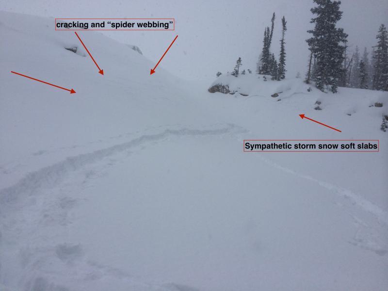
This first photo highlights the touchy storm snow we encountered. Our intention was to travel up through this gap, but when I approached it the steeper slope on the left spider-webbed and remotely triggered small and soft storm snow slabs. Pretty clear it was not a day to travel into the alpine and instead opted for safer terrain.

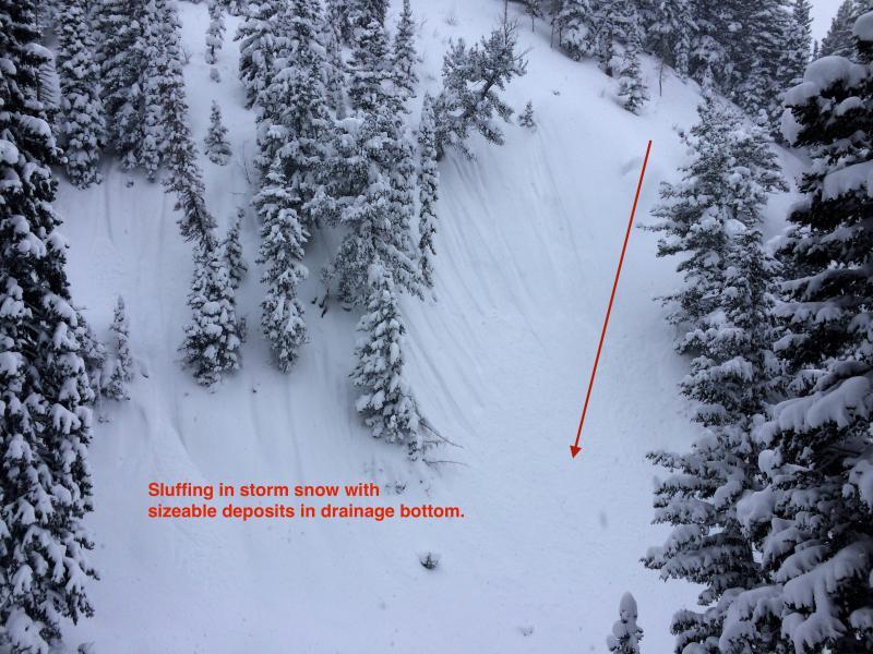
Second photo shows the sluffing on steeper drainage walls with decent debris piles noted at the bottom.

Quite clear we have tremendous spatial variability - with two slides reported on Saturday, yet also plenty of steeper slopes were skiied without incident. Storm snow is relatively easy to manage, but the lingering persistent slab issue not so. Given the new load we are expecting Sunday and Monday, still not ready to commit to steep slopes with any consequence. Especially concerned in thinner snowpack areas.

Hazard today was clearly Considerable, and will expect the same for Monday. But if we get more snow and wind than forecasted, it could easily go to High by Monday morning.

Today's Observed Danger Rating
Considerable
Tomorrows Estimated Danger Rating
Considerable