Observation: Snake Creek

Observation Date
12/19/2014
Observer Name
Toddeo
Region
Salt Lake » Big Cottonwood Canyon » Brighton Perimeter » Snake Creek Pass
Location Name or Route
Snake Creek
Weather
Sky
Broken
Precipitation
Light Snowfall
Wind Direction
South
Wind Speed
Light
Weather Comments
Clouds picked up in the afternoon, very light showers. Trace new, rimed stellers and graupel.
Snow Characteristics
Snow Surface Conditions
Faceted Loose
Snow Characteristics Comments

No detailed pits today. Went to look at just how weak the snow surface is. Looked at all aspects except NW.

Snow surface is weak and faceted on all aspects.

North facing aspects contain surface facets >5mm (photo), these aspects are capped with up to 8" of very weak faceted/recrystallized snow. Underlying snow ranges from areas that are rotted to the ground (sheltered areas) to some supportable 3 finger density decomposed slabs. The mid-pack has degraded significantly in the last 10 days in this area.

South facing aspects contain finer grained surface facets and generally 4" of snow siting on a supportable crust. The snow underlaying the crust consists of various faceted/recrystallized snow and decomposed crust sandwiches. Some south aspects may have gotten just damp enough to help stabilize the surface facets. There may be some minor crusts in the am.

A trace of new snow during the afternoon, additional showers tonight may preserve the surface hoar in places.

Red Flags
Red Flags
Poor Snowpack Structure
Red Flags Comments
North aspects, the concerns are twofold: with the addition of forecasted storm totals both the surface facets and deeper weak snow will be suspect. The weak midpack in sheltered areas could easily cause avalanches to step down, entraining significant amounts of snow possibly to the ground. South facing aspects the hazard will primarily be on surface snow, unless the load is significant enough to step down through the crust.
Avalanche Problem #1
Problem
New Snow
Trend
Increasing Danger
Problem #1 Comments

Due to weak surface snow. It is possible that tonights snow will preserve the surface facets in many locations. The forecasted heavy snow will form a density inversion.

Avalanche Problem #2
Problem
Persistent Weak Layer
Trend
Increasing Danger
Problem #2 Comments

Surface snow avalanches could easily step down to the ground (this assumes that the snow total forecast is correct....)

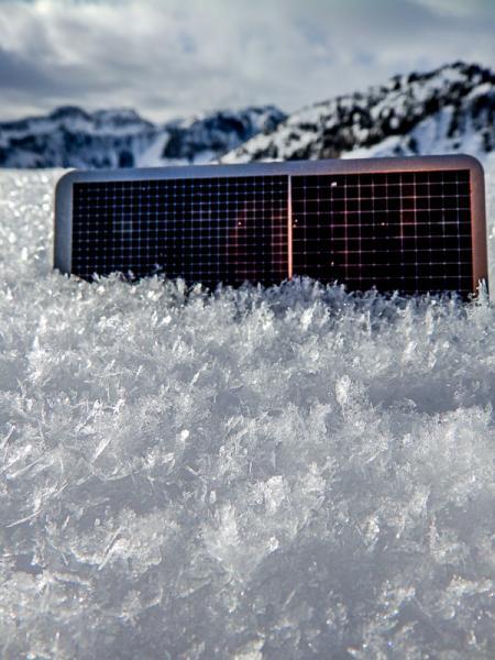
lst photo is facets on north aspects. Forecaster note: Todd's eyes must be getting bad. This is surface hoar. :)

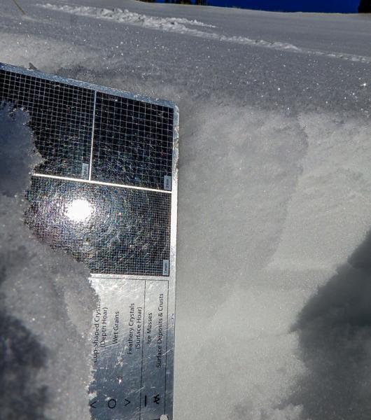
2nd photo shows surface facets and 4" of snow above crust.

I would fully expect the hazard to climb to high if the forecast is correct and we get up to1.5 to 2" of water weight. Could be exciting! I wold expect sensitive conditions in areas typically considered safe.

Today's Observed Danger Rating
Low
Tomorrows Estimated Danger Rating
Moderate