

Forecast for the Uintas Area Mountains

Wednesday morning, November 26, 2014
A CONSIDERABLE avalanche danger exists on wind drifted slopes at upper elevations. Human triggered avalanches are probable on leeward slopes, especially those with an easterly component to there aspect.
Mid elevations offer a MODERATE avalanche danger and human triggered avalanches are possible on steep slopes with recent deposits of wind drifted snow.
Remember- triggering even a small slide will expose stumps and rocks, instantly ruing your day and quite possibly your season.
Looking for LOW avalanche danger? Head to slopes that had no pre-existing snow prior to the big weekend storm.

 Special Announcements
NEW THIS YEAR: You can now receive advisories by email for each region in the state. Go here for details.
 Weather and Snow
Skies are clearing as high pressure builds over the region. Currently, temperatures are balmy, in the low to mid 30's. Unfortunately, west and northwest winds crashed our the powder party and they're still blowing in the 60's along the high ridges.
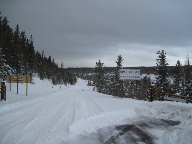
Ted snapped this image from the Bear River side of the range. While travel has vastly improved with last weekends storm, the range is still pretty thin and riding and turning options remain limited.
 Recent Avalanches
No news of the weird.

New Snow
Description
The snowpack is slowly adjusting to the big weekend storm and I suspect it's getting more difficult to trigger a deep, dangerous avalanche. However, given the snowpack structure and the consequences of triggering even a small slide that breaks to the ground, I'm not gonna hang it out and test my theories. When it comes to snow, the best way to manage the unknown is with your terrain choices. Remember- underneath the storm snow is early November snow that grew weak and sugary, especially on mid and upper elevation terrain facing the north half of the compass and that's exactly the type of terrain where you could trigger a slide today. Wanna avoid avalanches altogether? Simply ride on slopes that had no snow prior to last weekends storm or test your carving skills in low angle meadows, far away from anything steep above.
Additional Information
High pressure takes charge of our weather today with clearing skies and temperatures warming into the upper 30's. Spoiler alert... west and northwest winds are gonna be obnoxious this morning, blowing in the 50's and 60's along the high ridges, before relaxing a bit by afternoon. Warm and dry through the end of the week with a few passing clouds and snow showers late Sunday. The jury is still out on a storm early next week.
General Announcements
Remember your information can save lives. If you see anything we should know about, please participate in the creation of our own community avalanche advisory by submitting snow and avalanche conditions. You can call me directly at 801-231-2170, email [email protected], or email by clicking HERE
This is a great time of year to schedule a free avalanche awareness presentation for your group or club. You can contact me at 801-231-2170 or email [email protected]
Donate to your favorite non-profit –The Utah Avalanche Center. The UAC depends on contributions from users like you to support our work.
Benefit the Utah Avalanche Center when you buy or sell on ebay - set the Utah Avalanche Center as a favorite non-profit in your ebay account here and click on ebay gives when you buy or sell. You can choose to have your seller fees donated to the UAC, which doesn't cost you a penny.
Utah Avalanche Center mobile app - Get your advisory on your iPhone along with great navigation and rescue tools.
The information in this advisory is from the US Forest Service which is solely responsible for its content. This advisory describes general avalanche conditions and local variations always occur.
I will update this advisory by 7:00 AM Thursday Nov. 27, 2014.