Forecast for the Moab Area Mountains

Eric Trenbeath
Issued by Eric Trenbeath for
Friday, March 14, 2014

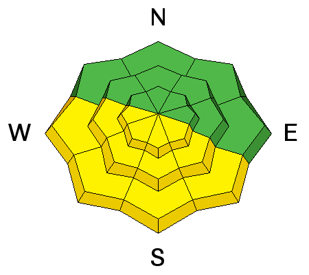
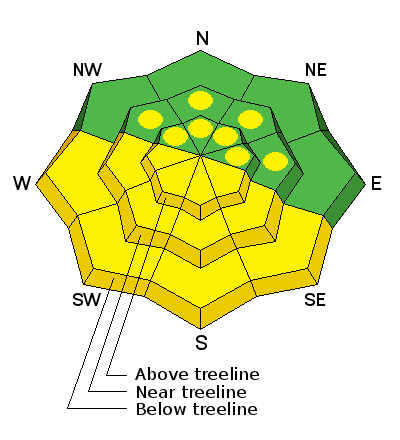
The overall avalanche danger is MODERATE at this time. The primary concern is for wet slide activity on sun exposed slopes during periods of daytime heating.

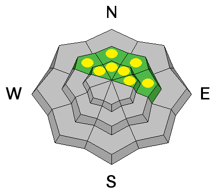
There also remains a MODERATE danger of triggering a deep, buried, persistent slab on mid to upper elevation slopes, steeper than 35 degrees that have a north through east aspect. .

Low
Moderate
Considerable
High
Extreme
Learn how to read the forecast here
Weather and Snow

La Sal Mountains

Mid morning clouds interrupted yesterday's corn pursuit though I found many frozen surfaces that just needed to thaw. Today, conditions should be good to go on mid elevation, SE-S-W aspects. Follow the sun, and as always, get off the slope when it starts to get wet and sloppy. Dry, powder like snow conditions can still be found on upper elevation, shady aspects though the open, upper bowls have sustained some wind damaged. Winds are light on Pre-Laurel this morning, averaging less then 10 mph from the ESE, and it is 16 degrees at 10,000'.

Winds and temperature on Pre-Laurel Peak (11,705')

Temperature and new snow totals in Gold Basin (10,050')

Total snow depth and temperature near Geyser Pass Trailhead (9850')

Abajo Mountains

Continued low snow, and spring like snow conditions reign over the Abajo Mountains. Many slopes with S-E-SW aspects are already melted off down to the ground.

Winds and temperature on Abajo Peak.

Snow totals at Camp Jackson (8968')

Ad
Avalanche Problem #1
Wet Snow
Type
Location
Likelihood
Size
Description

The danger for wet slide activity will be mostly low today, but could rise to moderate on sun exposed slopes by the afternoon. Be alert to signs of instability such as sloppy wet snow, loose sluffs, and roller balls, or pin wheels coming down the mountain. If any of these signs are present, it is time to stay off of and out from under steep, sun exposed slopes.

Avalanche Problem #2
New Snow
Type
Location
Likelihood
Size
Description

The danger of triggering a persistent slab has become very isolated, though It still may be possible to trigger one in areas that have the weakest snow. Areas of weakest snow can be found in steep, rocky, or slightly wooded terrain, facing the north half of the compass, at upper mid to upper elevations. Or right around tree line. I would still exercise caution in these areas.

Additional Information

Today, look for mostly sunny skies in the mountains with high temperatures at 10,000' to be in the upper 30's. Winds will be on the increase from the NE shifting to NW by afternoon averaging 10-15 mph. Tonight will bring us a brief brush by of clouds and slight chance of snow. The weekend looks to be sunny with increasing temperatures and increasing winds as well.

General Announcements

OBSERVATIONS: If you are out and about in the mountains, I'd love to know what you are seeing so please SUBMIT OBSERVATIONS You can read current OBSERVATIONS HERE.

LUNA GROOMING INFORMATION: Grooming conditions are kind of rugged. The trails have gone through a melt freeze cycle and have seen lots of traffic so an uneven surface with frozen ruts is the soup du jour.

ROAD CONDITIONS: The road is passable, alternating between patches of dry ground, packed snow and ice that gets sloppy late in the day.

UAC MOBILE APP: Get your advisory on your iphone with this app