La Sal Mountains
In an amazingly intense flurry, the La Sals picked up 4" in about 3 hours yesterday greatly improving turning and riding conditions. Up to 6" fell in select locations. It is that time of year however, and a strong sun put the hurt on exposed surfaces. Today, good powder will still be found in sheltered areas, but take your glop stopper to gaurd against skin build up, and wax your skis. Ridge top, northerly winds averaged 20 mph overnight, and as of 6 a.m. this morning they are blowing 30-40 mph from the NE on Pre Laurel Peak. If not confined to this elevation, they will have affected the new snow in exposed, upper elevation bowls. It is currently 18 degrees at 10,000'.
Winds and temperature on Pre-Laurel Peak (11,705')
Temperature and new snow totals in Gold Basin (10,050')
Total snow depth and temperature near Geyser Pass Trailhead (9850')
Abajo Mountains
Winds on Abajo Peak are averaging 10-20 mph from the NW, and the temperature at Buckboard Flat is 30 degrees. Snow last weekend improved conditions a bit but we are playing a difficult game of catch up this late in the season.
Snow totals at Camp Jackson (8968')
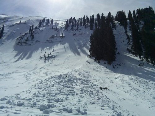
This is old news in avalanche world, but I got up Thursday to look at the Coyote Chute slide that was reported last Sunday. It turned out to be significantly larger than reported, as it wrapped around the ridge and out of sight. I estimate it to be about 800' wide with a maximum crown depth of 8'. It was caused by wind loading that finally over stressed buried weak layers underneath. this was an old snow avalanche, bringing home everything we say about buried persistent slabs, and the possibility of them being triggered by an over riding wind slab.