Observation: Coalpit

Observation Date
3/5/2014
Observer Name
Trent Meisenheimer
Region
Salt Lake » Little Cottonwood Canyon » Coalpit
Location Name or Route
White Pine - Hogum - Coal Pit
Weather
Sky
Clear
Wind Direction
West
Wind Speed
Light
Weather Comments
Sunny blue day in the am, high thin clouds, grey and flat light by 3:00pm
Snow Characteristics
New Snow Depth
4"
New Snow Density
Medium
Snow Surface Conditions
Powder
Dense Loose
Wind Crust
Melt-Freeze Crust
Damp
Snow Characteristics Comments

The sun was the biggest concern today, but the slight breeze and thin clouds kept the wet activity at bay. Found mostly supportable snow with a firm base throughout our travels.

Lots of grauple pooled in runout zones and transition areas, keep that in mind for the next time it snows. Well preserved, even under the solar crusts, 1-3 ft deep in places. I could see this being tricky in steep terrain next time it snows. All it would take is 6-10 inches of snow with a bit of wind and the grauple could be the weak layer. Just a thought.

Interesting note: The snowpack in Coal Pit is much different than all the other areas I have traveled in around the Wasatch. The Coal Pit headwall was wind blasted cream with a firm base. However, out of the wind effected terrain there was about a foot of dense supportable snow with facets underneath, if you stepped out of your ski or board you would sink to your waist in bottomless faceted grains.

Clearly - Coal Pit is a shallow snowpack zone but I found this a bit alarming with just how weak the faceted snow really was. Coal Pit did avalanche at some point as there was big debris piles in the runout zone; after the first bench. It was a fairly small avalanche compared to the scale of the place.

Red Flags
Red Flags
Recent Avalanches
Wind Loading
Rapid Warming
Poor Snowpack Structure
Red Flags Comments
Sun was the biggest concern with being on and under big slopes. We got a later start in hopes that the east face would be shaded and cooled off by early afternoon. There was a significant wet slide that released shortly before we got there aways down from the Needle, it did hit the creek at the bottom. Other than that, only rollerballs and minor point release wet activity noted.
Avalanche Problem #1
Problem
Persistent Weak Layer
Trend
Increasing Danger
Problem #1 Comments

Wind slabs were building at the top of Coal Pit around 3:45 pm. There was a steady breeze drifting snow onto the lee slopes. A well placed slope cut produced no results. Slope cuts work great for this kind of instability.

Comments

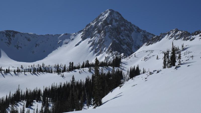
North east side of Pfeifferhorn Peak in the afternoon sun. Then wrapped around to the north west side as well.

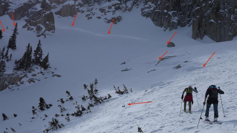
This photo was a slab avalanche that pulled out a few days ago I would assume. There was a significant amount of debris in the runout of the Needle from this avalanche (debris was 10 -15 ft deep). It also appeared to have triggered another piece of snow on a lower flank as well.

Not sure on the weak layer, I did find shallow places with faceted snow on the way up the needle especially around rocks. As you can see in the photo this avalanche broke on a steep slope that was rocky. However, its hard to say if it actually was faceted snow or the hardness change in the recent storm layers.

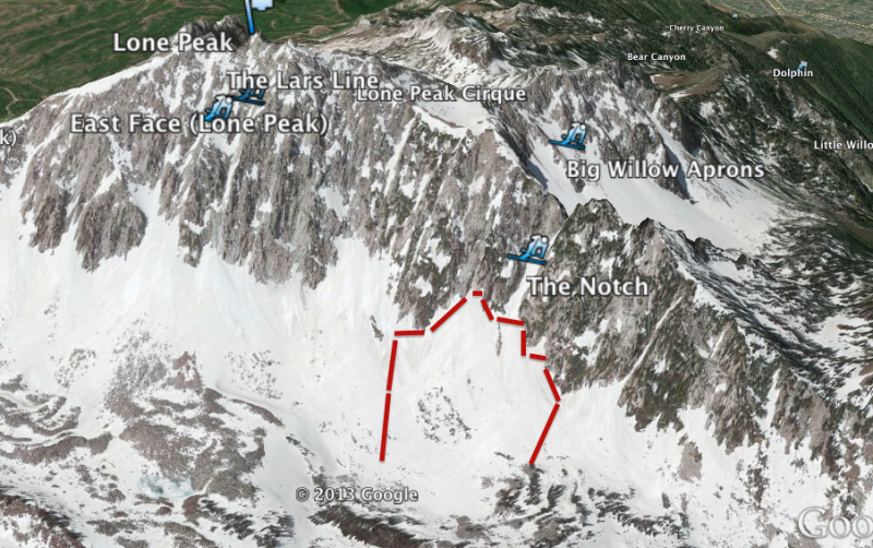
Another and more significant avalanche was noted on the east face of Lone Peak, in the apron. This looked to be more recent, probably yesterday with the high rain/snow line. It was a big avalanche that likely failed on old faceted snow, It was roughly 300 ft wide 2-5 feet deep would be my guess.

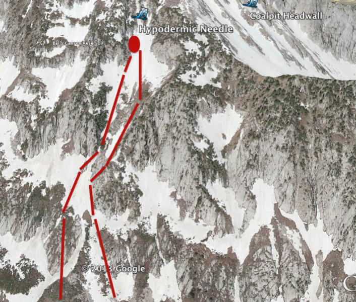
It was flat light and windy so I didn't take out the camera. Thanks to wasatchbackcountryskiing.com map I can draw in the rough estimates.

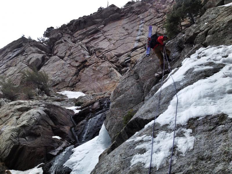
Just in case you want to go there, don't forget to bring a rope and save some energy for the wicked down climbing on snow and ice covered boulders to get out.

Today's Observed Danger Rating
Moderate
Tomorrows Estimated Danger Rating
None