icon-add
Observation
Menu
×
Menu
Forecasts
Logan
Ogden
Salt Lake
Provo
Uintas
Skyline
Moab
Abajos
Weather
Archives
How to read the forecast
Observations & Avalanches
Submit Observation
Observations Explorer
All Observations
Avalanches
Fatalities
Weather
Place Names Map
Archives
Education
Avalanche Class List
UAC Class List
Online Classes
Resources and Tutorials
Avalanche Awareness
Develop Skills
Events
Store
About
Contact
Who we are
Core Values
Staff
Board of Directors
Past Forecasters
Sponsors
Annual Reports
Sign In
Blog
Donate / Join
Search
Forecasts
Logan
Ogden
Salt Lake
Provo
Uintas
Skyline
Moab
Abajos
Weather
Archives
How to read the forecast
Observations & Avalanches
Submit Observation
Observations Explorer
All Observations
Avalanches
Fatalities
Weather
Place Names Map
Archives
Education
Avalanche Class List
UAC Class List
Online Classes
Resources and Tutorials
Avalanche Awareness
Develop Skills
Events
Store
About
Contact
Who we are
Core Values
Staff
Board of Directors
Past Forecasters
Sponsors
Annual Reports
Sign In
Blog
Menu
Search
icon-add
Observation
Donate / Join
Submit Observation
Observations Explorer
All Observations
Avalanches
Fatalities
Weather
Place Names Map
Archives
Submit Observation
Observations Explorer
All Observations
Avalanches
Fatalities
Weather
Place Names Map
Archives
Observation: Bear Trap
Observation Date
3/4/2014
Observer Name
Jenna Malone
Region
Salt Lake » Big Cottonwood Canyon » Bear Trap
Location Name or Route
Bear Trap
Weather
Sky
Overcast
Precipitation
Light Snowfall
Wind Direction
Southwest
Wind Speed
Light
Weather Comments
S1 at trailhead, but skies cleared (to broken) and precip abated approx 1430. Some sunshine late in day.
Snow Characteristics
New Snow Depth
4"
New Snow Density
Medium
Snow Surface Conditions
Powder
Dense Loose
Snow Characteristics Comments
Dense powder on an older supportable melt freeze crust, storm snow deep enough to provide good skiing.
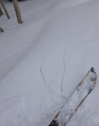
Red Flags
Red Flags
Wind Loading
Cracking
Rapid Warming
Poor Snowpack Structure
Red Flags Comments
Localized cracking where wind loading had occurred (N and NE ridges).
Avalanche Problem #1
Problem
Persistent Weak Layer
Trend
Same
Problem #1 Comments
While we skied more windward aspects today, we saw heavily corniced NW ridges and localized cracking in wind loaded micro terrain.
Avalanche Problem #2
Problem
Persistent Weak Layer
Trend
Decreasing Danger
Problem #2 Comments
No results on our stability tests today, though we dug in deep snowpack and on WNW, so likely not representative of where this layer is worst (high Norths?). After no failure within the standard 30 taps, we were able to pry out our ECT block, causing it to fail within the basal facets. The whole block was cohesive, leading us to think that propagation propensity (and consequences) would be high if it were to fail.
Snow Profile
Aspect
West
Elevation
9,800'
Slope Angle
28°
Today's Observed Danger Rating
Moderate
Tomorrows Estimated Danger Rating
Moderate
Coordinates