

Forecast for the Moab Area Mountains

Sunday morning, March 2, 2014
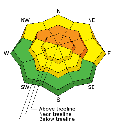
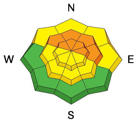
The avalanche danger remains CONSIDERABLE in areas that have recent deposits of wind drifted snow at mid and upper elevations that primarily face the north half of the compass. This danger applies both to recently formed wind slabs, and to the danger of triggering a deeper, persistent slab. Back country travelers should stay off of, and out from under, slopes steeper than about 34 degrees in these areas.
There is a MODERATE avalanche danger at mid and lower elevations that have recent deposits of wind drifted snow.
 Weather and Snow
La Sal Mountains
Someone unplugged the fan. After yesterday's blow fest, winds on Pre Laurel Peak are virtually non existent this morning. Between midnight and 4 a.m. they registered 0 and are now in the single digits and northerly. Storm totals since Thursday are about 8", with an inch of water, which translates to some pretty dense snow. In sheltered areas, a dense, storm slab makes for fast and creamy, riding and turning conditions. Wind exposed areas have been thoroughly hammered with some south and west facing slopes showing bare ground.
Winds and temperature on Pre-Laurel Peak (11,705')
Temperature and new snow totals in Gold Basin (10,050')
Total snow depth and temperature near Geyser Pass Trailhead (9850')
Abajo Mountains
Winds on Abajo Peak yesterday were much more behaved averaging less than 10 mph and gusting to 25 mph from the WSW. This morning they have swung around to the WNW and are blowing in the single digits. Buckboard Flat received about 7" of dense new snow since Thursday. This will have improved conditions a bit but we are playing a difficult game of catch up this late in the season.
Snow totals at Camp Jackson (8968')
Persistent Weak Layer
Description
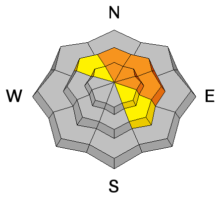
Stiff wind slabs formed over the past couple of days will have lost much of their sensitivity. Nevertheless, with their depth, and relative density, they will pack a punch if triggered. They also have the potential to step down into weaker buried layers. Most of these slabs will be found on mid to upper elevation terrain that faces the north half of the compass, but cross loading is also a factor on the lee sides of sub ridges and terrain features. Be alert to the usual signs of recently deposited wind slabs such as smooth, rounded pillows, or drifts of new snow. And watch for signs of cracking in the snow surface.
New Snow
Description
Persistent slab concerns have definitely been re-activated. There is plenty of weak snow under there, and the new snow, combined with the added weight of a skier or rider, could be just enough to tip the balance causing a deep and dangerous avalanche. Areas of weakest snow can be found in steep, rocky, or slightly wooded terrain, facing the north half of the compass.
Additional Information
Today, look for partly sunny skies, northwesterly winds at about 10 mph, and a high temperature of around 30 degrees at 10,000'. A weak, embedded wave on a westerly flow will bring us periods of instability over the next couple days with alternating, slight chances of snow, and partly sunny skies.
General Announcements
OBSERVATIONS: If you are out and about in the mountains, I'd love to know what you are seeing so please SUBMIT OBSERVATIONS You can read current OBSERVATIONS HERE.
LUNA GROOMING INFORMATION: Trails will be mostly snow covered today with grooming scheduled for Monday
ROAD CONDITIONS: The road has not been plowed yet though traffic on Saturday has continued to pack the snow in. Expect plowing by Monday or Tuesday, and be aware that you may encounter a temporary road closure if you aren't early enough to get ahead of them.
UAC MOBILE APP: Get your advisory on your iphone with this app