


Forecast for the Uintas Area Mountains

Saturday morning, March 1, 2014
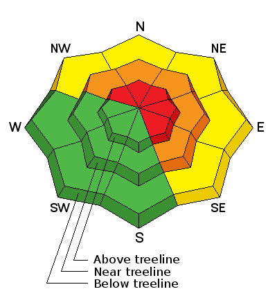
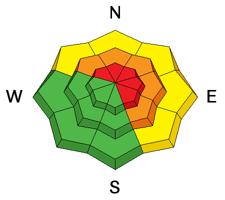
NO GO TERRAIN- in the wind zone at upper elevations, where the avalanche danger is HIGH today. Both human triggered and natural avalanches are very likely on all steep, wind drifted slopes, particularly those facing the north half of the compass. Once triggered, today's avalanches can break deep and wide, creating a very dangerous slide.
A CONSIDERABLE avalanche danger is found at mid elevations and human triggered avalanches are probable on steep, wind drifted slopes.
Strong winds have gotten into low elevation terrain as well. A MODERATE danger is found on steep slopes with recent deposits of wind drifted snow and human triggered avalanches are possible .
GO TO TERRAIN- gentle, wind sheltered slopes with no steep terrain above or adjacent to where you're riding. You'll find a LOW avalanche danger in terrain with these characteristics.
Avalanche Watch
THIS AVALANCHE WARNING IS FOR THE MOUNTAINS OF NORTHERN AND CENTRAL UTAH. HEAVY SNOW AND HIGH WIND HAVE CREATED A HIGH AVALANCHE DANGER. BACKCOUNTRY TRAVELERS SHOULD STAY ON SLOPES LESS THAN 30 DEGREES AND AVOID AVALANCHE RUN OUT AREAS. THIS WARNING DOES NOT INCLUDE SKI AREAS OR HIGHWAYS WHERE AVALANCHE CONTROL IS NORMALLY DONE.
 Weather and Snow
March is roaring in like the Lion of Zion! Southwest winds blew in the 30's and 40's yesterday afternoon, increasing around midnight and are currently cranking 60 to 90 mph along the high peaks. 6" of snow fell overnight and storm totals are nearing 18" in most upper elevation locations. Temperatures are mild, in the mid 20's and low 30's. Riding and turning conditions are gonna be a bit of a mixed bag. Low and mid elevation wind sheltered terrain is gonna be your best bet.
Click here for current winds, temperatures, and snowfall throughout the range.
Click here for trip reports and avalanche observations.
 Recent Avalanches
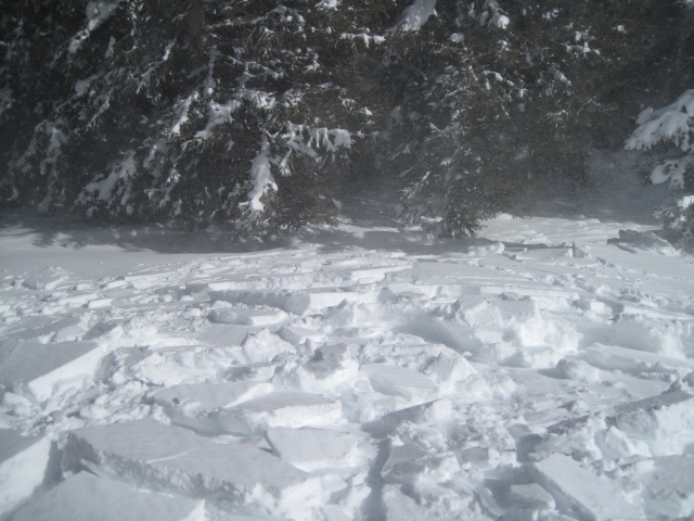
Ted found very sensitive wind drifts formed rapidly on upper elevation leeward slopes yesterday. More avalanche activity is found here.

Persistent Weak Layer
Description
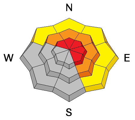
Our snowpack is up against the ropes this morning, reeling from the strong winds and heavy snow and trying to adjust to all this added weight. Like the Thrilla in Manilla, this flurry of jabs and upper cuts is testing the strength of our snowpack which is still trying to adjust to the last series of storms. While many slopes are thick and strong, the snow structure remains questionable, especially in steep, rocky terrain facing the north half of the compass. Problem is... the surface snow feels strong and solid underneath us, but it's the bad mojo near the ground that's the big red flag. Strong snow over weak snow often suggests false green light conditions, allowing us to get well out onto the slope or put several sets of tracks on the hill before we find a weakness, collapse the slope, and now all bets are off. Once triggered, avalanches can break deep and wide, taking out the entire seasons snowpack. Best way to manage this situation is with terrain choices. Simply tone down your objectives the next few days and avoid being on or under steep leeward slopes. Slopes facing the south half of the compass offer more predictable avalanche conditions.
The Uintas are white and slopes are well connected. This is the type of terrain where you could trigger a large slide that break to weak snow near the ground.
Persistent Weak Layer
Description
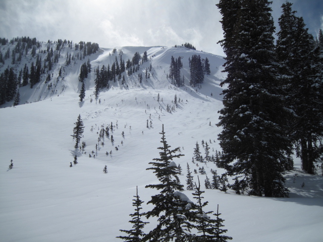
Wind drifts are becoming unmanageably deep and breaking wider than you might expect. They're packing a hefty punch and will quickly ruin your day, especially if you get slammed into trees or knocked over a cliff. In addition, once triggered, today's drifts have the possibility to break into weaker layers of snow, buried deeper in the snowpack. In either case, a seemingly benign situation can get quickly out of hand. As always, look for and avoid any fat, rounded pillow of snow, especially if it sounds hollow like a drum.
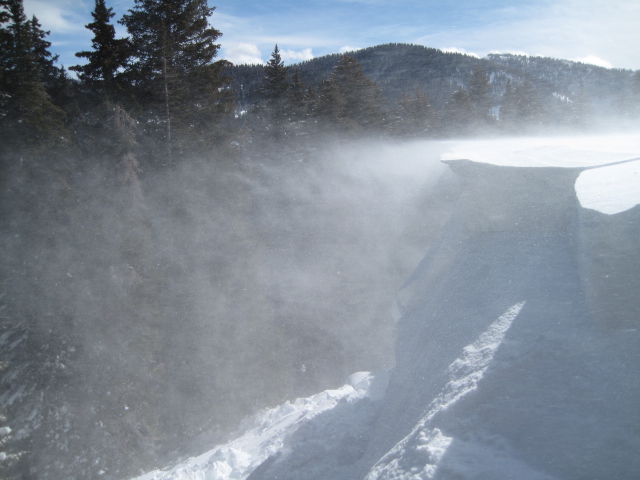
Strong west and southwest winds had no problem moving lots of snow around yesterday. Due to the strength of the wind, today's fresh slabs will be lower on the slope than you might expect.
Additional Information
Nuking winds along the ridges are the big headline news. Gusting 70-90 mph, southwest winds should diminish late this afternoon. Snow totals are going to be hit or miss, but an additional 6" is a pretty good bet. High temperatures don't vary much from where we're at this morning, and overnight lows dip into the upper teens. Scattered snow showers linger into Sunday morning and then high pressure begins to build for early in the week.
General Announcements
Remember your information can save lives. If you see anything we should know about, please participate in the creation of our own community avalanche advisory by submitting snow and avalanche conditions. You can call me directly at 801-231-2170, email [email protected], or email by clicking HERE
This is a great time of year to schedule a free avalanche awareness presentation for your group or club. You can contact me at 801-231-2170 or email [email protected]
Donate to your favorite non-profit –The Utah Avalanche Center. The UAC depends on contributions from users like you to support our work.
Benefit the Utah Avalanche Center when you buy or sell on ebay - set the Utah Avalanche Center as a favorite non-profit in your ebay account here and click on ebay gives when you buy or sell. You can choose to have your seller fees donated to the UAC, which doesn't cost you a penny.
Utah Avalanche Center mobile app - Get your advisory on your iPhone along with great navigation and rescue tools.
The information in this advisory is from the US Forest Service which is solely responsible for its content. This advisory describes general avalanche conditions and local variations always occur.
I will update this advisory by 7:00 AM on Sunday Mar. 2, 2014