Forecast for the Uintas Area Mountains

Craig Gordon
Issued by Craig Gordon for
Monday, February 10, 2014

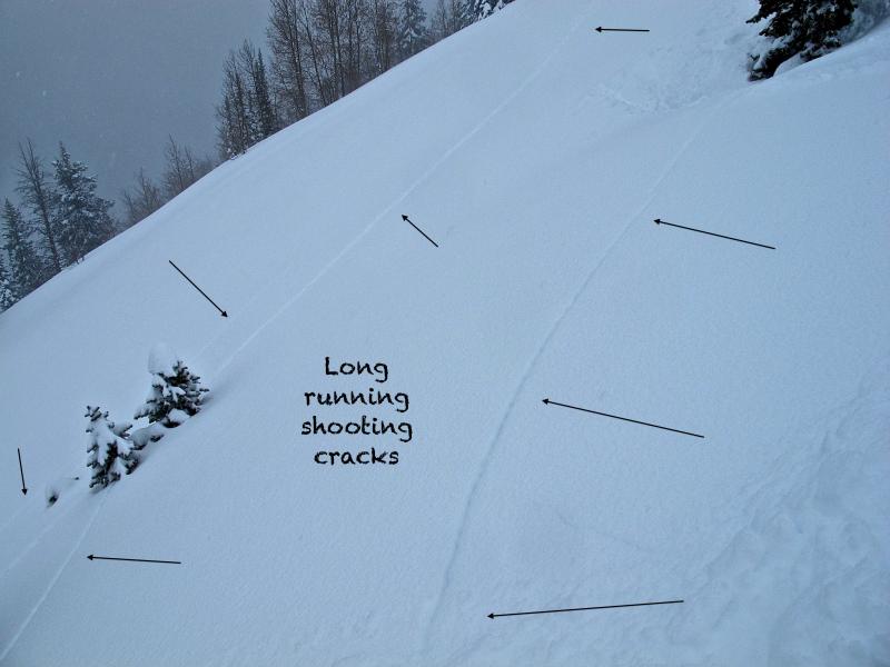
It's dangerous out there and this is the real deal. Avalanches are breaking deep and wide, taking out the entire seasons snowpack. If you're getting on the snow today, please take a moment and think about the consequences of triggering an avalanche and the possibility of not coming home to your family.

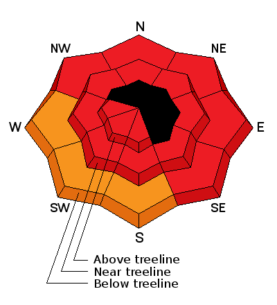
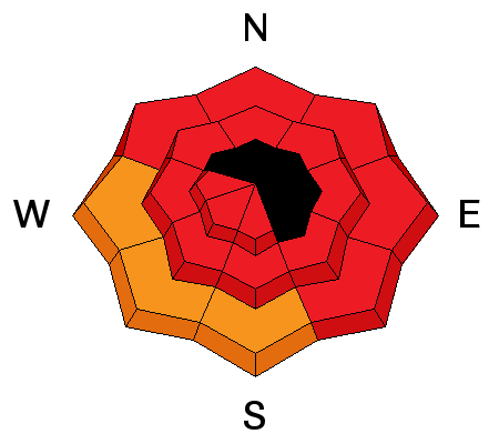
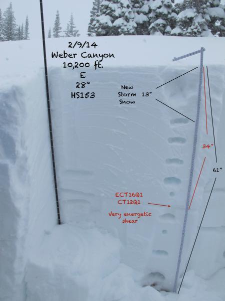
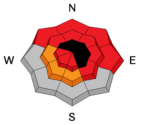
At all elevations, the avalanche danger is HIGH today and borders on EXTREME in some locations. Both human triggered and natural avalanches are very likely on all steep, wind drifted slopes. The danger is most pronounced on slopes facing the north half of the compass, particularly those with an easterly component to their aspect. Once triggered avalanches have the possibility to break deep and wide, creating a dangerous and possibly unsurvivable slide.

Low
Moderate
Considerable
High
Extreme
Learn how to read the forecast here
Avalanche Warning

AN AVALANCHE WARNING CONTINUES FOR ALL THE MOUNTAINS OF NORTHERN AND CENTRAL UTAH...SOUTHEAST IDAHO...THE WESTERN UINTAS...AND SOUTH TO THE MANTI-SKYLINE PLATEAU TO I-70. HEAVY SNOW AND WIND HAS PUSHED THE AVALANCHE DANGER TO HIGH, BORDERING ON EXTREME. AVOID BACKCOUNTRY TRAVEL ALTOGETHER...AS LARGE NATURAL AND HUMAN TRIGGERED AVALANCHES REMAIN LIKELY IN MANY AREAS ACROSS THE STATE.

Special Announcements

Our collective prayers, energy, and condolences go out to the friends and families of Ashleigh Nicole Cox and Clint Conover who were both tragically killed in separate avalanche accidents this weekend.

Weather and Snow

Skies are mostly cloudy and it's dumping. West winds have mellowed and are currently blowing 15-25 mph. Temperatures are in the mid to upper 20's. Storm totals are crushing with 3'-4' of snow and nearly 4" of water.

Click here for current winds, temperatures, and snowfall throughout the range.

Click here for trip reports and avalanche observations.

Recent Avalanches

Lots of booming collapses and remotely triggered slides. Most impressive is a slide triggered from a distance on a SE facing slope at 9500'. 8'-10' deep and 300' wide, the slide broke to the ground, running far, breaking trees as it descended the slope.

Recent avalanche activity is found here.

Ad
Avalanche Problem #1
Persistent Weak Layer
Type
Location
Likelihood
Size
Description

Avalanches are breaking unpredictably wide and deep. Once triggered, today's slides will easily break to weaker layers buried deep in the snowpack, resulting in a dangerous and possibly unsurvivable slide. Cracking and collapsing along with recent avalanches on the same type of terrain you wanna ride are huge clues to unstable snow.

You don't have to trigger avalanches to know it's sketchy out there. JG's pit results say it all!

Avalanche Problem #2
Persistent Weak Layer
Type
Location
Likelihood
Size
Description

It's pretty straightforward. Strong winds, lots of water weight, and rising temperatures have severely stressed weak layers of snow near the ground, especially on slopes where the pack remains thin and fragile. Much of our terrain throughout the range is unusually shallow for this time of year and steep, rocky slopes, especially those facing the north half of the compass need to be avoided. Deep, dangerous avalanches can be triggered from relatively flat terrain low on the slope. Avalanches are running far, fast, and furious. Today you'll need to avoid being on, below, or adjacent to steep, wind drifted terrain.

Additional Information

The last in the recent series of storm systems will continue to affect the area this morning before moving east this afternoon. Drier air follows for midweek, before another round of moist westerly flow returns late Wednesday through Thursday.

General Announcements

Remember your information can save lives. If you see anything we should know about, please participate in the creation of our own community avalanche advisory by submitting snow and avalanche conditions. You can call me directly at 801-231-2170, email [email protected], or email by clicking HERE

This is a great time of year to schedule a free avalanche awareness presentation for your group or club. You can contact me at 801-231-2170 or email [email protected]

Donate to your favorite non-profit –The Utah Avalanche Center. The UAC depends on contributions from users like you to support our work.

Benefit the Utah Avalanche Center when you buy or sell on ebay - set the Utah Avalanche Center as a favorite non-profit in your ebay account here and click on ebay gives when you buy or sell. You can choose to have your seller fees donated to the UAC, which doesn't cost you a penny.

Utah Avalanche Center mobile app - Get your advisory on your iPhone along with great navigation and rescue tools.

The information in this advisory is from the US Forest Service which is solely responsible for its content. This advisory describes general avalanche conditions and local variations always occur.

I will update this advisory by 7:00 AM on Tuesday Feb. 11, 2014