Observation: Greens Basin

Observation Date
2/8/2014
Observer Name
Greg Gagne with Mark Johnston
Region
Salt Lake » Big Cottonwood Canyon » Greens Basin
Location Name or Route
Greens Basin
Weather
Sky
Obscured
Precipitation
Moderate Snowfall
Wind Direction
West
Wind Speed
Moderate
Weather Comments
Just below freezing at Silver Fk trailhead, -5C at 9500'. Sustained Moderate winds along ridgeline, with occasional Strong gusts. Period of S2 snowfall rate (about an inch/hr) late morning.
Snow Characteristics
New Snow Depth
10"
New Snow Density
Medium
Snow Surface Conditions
Powder
Wind Crust
Snow Characteristics Comments

Dense, wind drifted snow along ridgelines > 9000' with surprisingly somewhat light-density snow out of wind affected terrain. Several density inversions within storm snow with no apparent pattern. HS at 9000' roughly 120 cms. Apparently 15-20 cms (6"-8") overnight with another 10 cms falling during the morning.

Red Flags
Red Flags
Recent Avalanches
Heavy Snowfall
Wind Loading
Cracking
Collapsing
Poor Snowpack Structure
Red Flags Comments
A "2" x 4"" day - the snowpack is hitting you upside the head with a 2" x 4" - better pay attention.
Avalanche Problem #1
Problem
Persistent Weak Layer
Trend
Increasing Danger
Problem #1 Comments

Widespread wind drifts along lee ridge lines, although I was not yet finding wind drifted snow off of ridges. Wind drifts were mostly 4F hardness and between 30-45 cms (1-1.5'), although some deeper drifts were approaching 60 cms. Sensitive cornice formation as well. Fresh wind drifts were quite sensitive on test slopes, and cornices were easily provoked. Was finding wind drifts to fail at interface of lighter density snow from earlier this week, but with a poor snowpack structure, in open, steeper terrain I could imagine triggering a wind drifted slab could result in stepping down to persistent weaknesses deeper in the snowpack. With continued wind expected, easy to identify an increasing danger trendline.

Avalanche Problem #2
Problem
New Snow
Trend
Increasing Danger
Problem #2 Comments

Was finding similar snowpack structure this morning in Green's that I was finding Thursday morning in Mineral Fork. Down about 50-75 cms (18"-30") I am finding two rain crusts forming a facet sandwich, with weak faceted snow below the lower crust. On at least 6 test slopes at a variety of elevations between 8500' and 9500' I was unable to isolate a column (CTV) with failures occurring in the faceted snow between the crusts or below the lower crust. On a lower-angled slope at 9200', my partner Mark Johnston (first descent artist of the necky and hard-to-find Johnston Couloir) was getting CT scores ~5 at a density inversion about 20 cms down, and CT 11 Q1/SC in the facet crust down 60 cms. With more snow and wind in the forecast, expect increasing hazard.

Comments

7:30 - 11:30 am tour in Greens Basin. Lower elevation rain, but found colder conditions up higher with surprisingly somewhat light-density snow outside of wind-affected terrain. At these mid-elevations, it was not upside-down and provided fun turning conditions on lower angled slopes. Trailbreaking was somewhat challenging, but skis were not submarining on you. Came away with the feeling that in wind-affected terrain, fresh wind drifts were large and sensitive and were creating a High avalanche danger. Didn't get the feeling that there has been enough water weight added to the snowpack outside of wind-affected terrain to tip the scale, but it seems close to that point. From the top down, general weaknesses are:

- density inversions within storm snow;

- lighter density snow from earlier this week (now buried 30-60 cms down);

- buried persistent weak layers 50-100 cms down.

Conservative choices today - steepest slope was 31 degrees, with nothing steeper above. Was finding lower angled slopes still providing decent ski & travel conditions.

All of this may change of course with significant amounts of snow, wind, and warming temps.

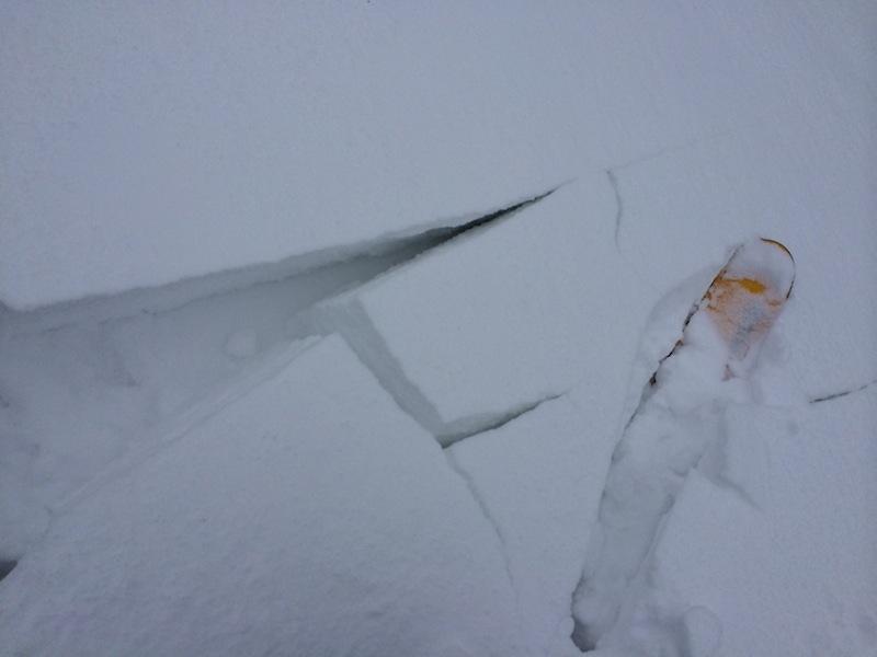
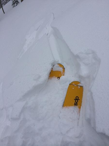
Took several photos and videos today, but blowing snow created poor visibility and hence, poor footage. Below are two showing cracking in wind slabs along leeward aspect of ridgeline.

Today's Observed Danger Rating
Considerable
Tomorrows Estimated Danger Rating
High