

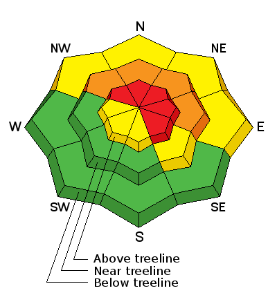
Forecast for the Uintas Area Mountains

Thursday morning, January 30, 2014
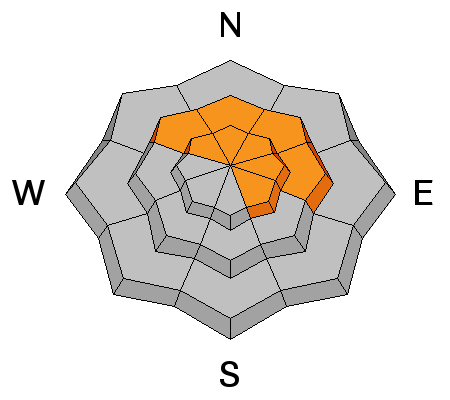
Above treeline in the wind zone a HIGH avalanche danger exists and human triggered avalanches are very likely. Terrain to avoid- steep, upper elevation, wind drifted slopes, particularly those facing the north half of the compass. Once triggered, avalanches have the possibility to break deep and wide, creating a dangerous avalanche.
Mid elevation, north facing terrain offers CONSIDERABLE avalanche danger and human triggered avalanches are likely on any steep, wind drifted slopes.
You'll encounter manageable avalanche conditions in terrain facing the south half of the compass where a MODERATE avalanche danger exists and fresh drifts will break predictably at or below your skis, board, or sled.
Go to terrain- If you're looking for LOW avalanche danger, head to wind sheltered terrain, especially where there are no steep slopes above or adjacent to where you're riding.
Special Avalanche Bulletin
THIS SPECIAL AVALANCHE ADVISORY IS FOR THE WASATCH MOUNTAINS SOUTH OF I-80...THE WESTERN UINTAS... AND THE CENTRAL MOUNTAINS OF UTAH INCLUDING THE MANTI SKYLINE...FISH LAKE PLATEAU...AND ALONG THE I-70 CORRIDOR. RAIN...SNOW AND STRONG WINDS HAVE CREATED A CONSIDERABLE TO HIGH AVALANCHE DANGER AT ALL ELEVATIONS. BACKCOUNTRY TRAVEL IS NOT RECOMMENDED.
Trent put together a brilliant tutorial describing the kind of avalanche dragon we're dealing with. Click here to view.
 Special Announcements
Snowbasin patrol leads the charge up the ridge. Huge thanks to Snowbasin and all the amazing athletes for bringing the stoke and hosting this years Freeride Workshop
Join the Utah Avalanche Center and Boondockers on Feb 20 and 22 for another avalanche & riding skills class. Registration is open now. Note that we changed the date from the original class posting.
 Weather and Snow
In case of emergency... break glass! Yep, someone found the winter switch last night.
A moist cold front slammed into the state overnight delivering over a foot of medium density snow throughout the range and it's a right-side up kinda storm (snow came in warm and went out cold). Southwest winds cranked in the 40's and 50's 'til about 11:00 last night when they turned northwesterly and mellowed into the low 20's. Currently, light snow is falling and temperatures are in the low teens and mid 20's. Riding and turning conditions have drastically improved overnight.
Click here for current winds, temperatures, and snowfall throughout the range.
Click here for trip reports and avalanche observations.
 Recent Avalanches
No news of the weird.
Recent avalanche activity is found here.

Persistent Weak Layer
Description
Strong southerly winds created drifts along the leeward side of upper elevation ridges and around terrain features like chutes, gullies, and sub-ridges. Yesterday's slabs are now covered over with fresh snow and may be more difficult to detect. None-the-less, you'll want to look for and avoid any fat, rounded, pillow of snow. While not quite as sensitive as yesterday, once triggered, drifts may break deeper and wider than you might expect.
Persistent Weak Layer
Description
More dangerous is the possibility of triggered a slide that breaks to weak snow near the ground. While water totals didn't add up like anticipated, this was a sudden change to our snowpack and I think many slopes just need a trigger to come along and kick the legs out from underneath. Any avalanche that breaks into deeply buried weak layers will be very dangerous. I'd continue to avoid steep, upper elevation, rocky slopes, especially those facing the north half of the compass.
Additional Information
Snow tapers off during the day and we can expect another couple inches before the storm winds down completely. Winds blow from the west and northwest, at speeds of 15-25 mph along the ridges. Temperatures don't vary much from where we're at this morning and then dip into the teens and single digits overnight. A few flurries are expected on Friday, but in general we're drying out.
General Announcements
Remember your information can save lives. If you see anything we should know about, please participate in the creation of our own community avalanche advisory by submitting snow and avalanche conditions. You can call me directly at 801-231-2170, email [email protected], or email by clicking HERE
This is a great time of year to schedule a free avalanche awareness presentation for your group or club. You can contact me at 801-231-2170 or email [email protected]
Donate to your favorite non-profit –The Utah Avalanche Center. The UAC depends on contributions from users like you to support our work.
Benefit the Utah Avalanche Center when you buy or sell on ebay - set the Utah Avalanche Center as a favorite non-profit in your ebay account here and click on ebay gives when you buy or sell. You can choose to have your seller fees donated to the UAC, which doesn't cost you a penny.
Utah Avalanche Center mobile app - Get your advisory on your iPhone along with great navigation and rescue tools.
The information in this advisory is from the US Forest Service which is solely responsible for its content. This advisory describes general avalanche conditions and local variations always occur.
I will update this advisory by 7:00 AM on Friday Jan. 31, 2014