
Forecast for the Uintas Area Mountains

Friday morning, January 17, 2014
Avalanches are harder to initiate, but if you do trigger a slide the end result will be devastating!
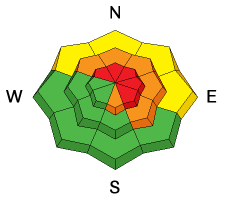
Terrain to avoid- steep, upper elevation slopes facing the north half of the compass, especially those in the wind zone with an easterly component to their aspect, where a HIGH avalanche danger exists. Human triggered avalanches are very likely.
A CONSIDERABLE avalanche danger is found on any steep wind drifted slope at mid elevations. Human triggered avalanches are likely.
Go to terrain- If you're looking for LOW avalanche danger, head to wind sheltered terrain, especially those facing the south half of the compass where there are no steep slopes above or adjacent to where you're riding.
 Special Announcements
This is the type of slide you'll be staring down if you trigger an avalanche today. Very dangerous avalanche conditions exist, particularly on steep, upper elevation slopes facing north, northeast and east. Deep, dangerous, and possibly unsurvivable human triggered avalanches are likely today in terrain with these characteristics.
Trent put together a brilliant viddy describing the snowpack setup. Click here to view.
 Weather and Snow
Skies are clear and temperatures are in the mid teens. Near the ridges, northwest winds are blowing 25-35 mph. Most wind exposed terrain is jacked, but we found soft settled powder yesterday in sheltered terrain. Meadows with no steep slopes above you are the ticket today.
Click here for current winds, temperatures, and snowfall throughout the range.
Click here for trip reports and avalanche observations.
 Recent Avalanches
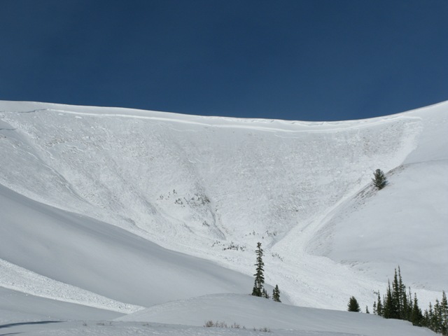
Morning sunlight illuminates a very large slide in upper Weber Canyon.
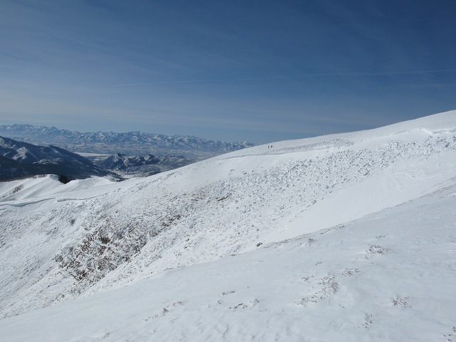
We took a look at this monster yesterday. The small dots on the horizon are my intrepid partners Bob Merrill and Trent Meisenheimer.
But wait... there's even more recent avalanche activity which can be found here.

Persistent Weak Layer
Description
Nothing has changed and our snowpack remains sketchy. While the snowpack slowly gains strength it remains deceptively tricky because it will feel solid under our sled, skis, or board. The snow will allow us to get well out onto the slope before it fails on sugary old snow near the ground. Once initiated, today's slides will break deep and wide, creating an unsurvivable avalanche. Complicating matters is the fact that you may still be able to trigger avalanches low on the slope or from a distance.
Remember- most avalanche accidents occur the first few sunny days right after a big storm. It doesn't mean you can't ride. It does mean you need to stay off of and out from under steep wind drifted slopes, especially slopes facing the north half of the compass.
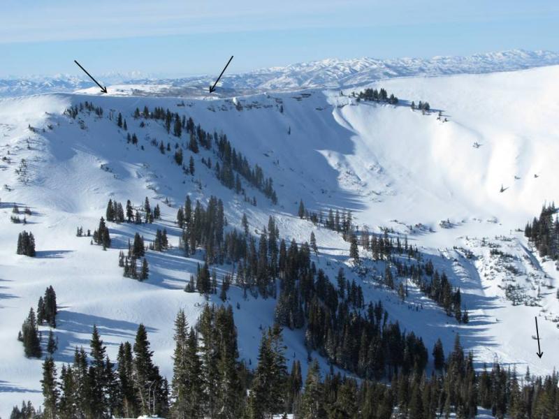
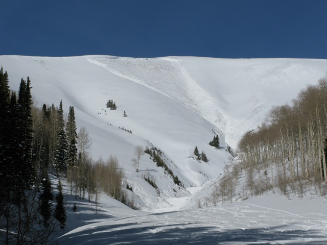
A bump in the winds Wednesday night triggered this long running avalanche on a steep northerly facing slope in upper Chalk Creek. The upper arrows indicate the width, while the lower arrow shows just how far this slide ran.
Cornice
Description
Cornices are huge, especially on the leeward side of upper elevation ridges. These monsters can easily break back further than you might expect, taking you for a nasty, unexpected ride down the elevator shaft, and possibly triggering a large avalanche as you both hit the slope below..
Additional Information
Sunny skies and warming temperatures are on tap for today. Northerly winds remain a nuisance along the high ridges, blowing in the 20's and 30's, eventually diminishing through the weekend. High temperatures climb into the mid 30's, dipping into the mid 20's overnight. Dry and mild conditions are in store for us the next couple of days..
General Announcements
Remember your information can save lives. If you see anything we should know about, please participate in the creation of our own community avalanche advisory by submitting snow and avalanche conditions. You can call me directly at 801-231-2170, email [email protected], or email by clicking HERE
This is a great time of year to schedule a free avalanche awareness presentation for your group or club. You can contact me at 801-231-2170 or email [email protected]
Donate to your favorite non-profit –The Utah Avalanche Center. The UAC depends on contributions from users like you to support our work.
Benefit the Utah Avalanche Center when you buy or sell on ebay - set the Utah Avalanche Center as a favorite non-profit in your ebay account here and click on ebay gives when you buy or sell. You can choose to have your seller fees donated to the UAC, which doesn't cost you a penny.
Utah Avalanche Center mobile app - Get your advisory on your iPhone along with great navigation and rescue tools.
The information in this advisory is from the US Forest Service which is solely responsible for its content. This advisory describes general avalanche conditions and local variations always occur.
I will update this advisory by 7:00 AM on Saturday Jan. 18, 2014