Observation: Bear Trap

Observation Date
1/10/2014
Observer Name
Greg Gagne
Region
Salt Lake » Big Cottonwood Canyon » Bear Trap
Location Name or Route
Beartrap
Weather
Sky
Overcast
Wind Direction
West
Wind Speed
Moderate
Weather Comments
-6 C with occasionally strong gusts (one almost knocking me over while on the skin track.) Terrain was causing winds to channel and cross-loading was evident on all aspects.
Snow Characteristics
New Snow Depth
16"
New Snow Density
Medium
Snow Surface Conditions
Powder
Snow Characteristics Comments

Hard to tell exact snow totals in mid-BCC. Best I can tell is that at outside of wind-affected areas, there appears to be 30-45 cms (12-18") storm totals. In wind affected terrain some drifts were over a meter. HOS on northwest aspects is now well over a meter, approaching 1.5 meters in wind-drifted terrain,

Red Flags
Red Flags
Recent Avalanches
Heavy Snowfall
Wind Loading
Poor Snowpack Structure
Red Flags Comments
No collapsing or cracking in the storm snow! I was out for a few hours mid-day Thursday and both storm snow and wind-drifted snow was quite sensitive, not so today. Did notice one small natural in steep terrain trap (photo) but otherwise visibility was too poor to notice any other naturals.
Avalanche Problem #1
Problem
Persistent Weak Layer
Trend
Increasing Danger
Problem #1 Comments

Widespread fresh dense wind slabs found at mid and upper elevations. Winds are gusting into the Strong category and as the wind channels, it creates cross-loading so you have to be suspicious of wind drifts on almost every aspect, but paying particular attention to lee-ward E aspects from the NW/W winds. Did jump on alot of test slopes with fresh wind drifts, but the wind slabs were not that sensitive to ski cuts and other quick stability tests. Am calling an increasing hazard with an increase in forecasted winds.

Avalanche Problem #2
Problem
Persistent Weak Layer
Trend
Increasing Danger
Problem #2 Comments

As Evelyn noted in Friday Jan 10 forecast, probably the first time I've seen deep slab identified in the forecast this season (probably the first time any UAC forecaster has even used the term "deep" this season!) With decent amounts of storm snow, the buried faceted layers can probably now be considered a deep slab issue. From numerous quick tests I performed over the past 2 days, I've been finding the weakest layers to be within the storm snow. On Thursday mid-day I was finding a density inversion that is now buried at least 30 cms (12") down to be the weakest layer. I was still identifying that layer today, but also finding other weaknesses within the storm snow as well. On several hasty pits I was unable to isolate a column (CTV) with failure occurring within storm snow. (Given both the stormy weather as well as weak snowpack, I especially find performing multiple quick tests to be far more useful than any one detailed pit.) So for the most part I am finding weaknesses within the storm snow to be the most visible, yet it is easy to imagine any avalanche breaking down into weak faceted snow on northerly aspects. With wind and another storm on the horizon for Saturday night, am calling an increasing danger.

Comments

With a rapid increase in (1) snow totals, (2) water weight, and (3) wind onto our pre-existing weak snowpack, it is pretty clear we have a heightened probability of avalanching. The lack of cracking and collapsing somewhat surprised me, and it's possible storm weaknesses will heal quite quickly, but the weak snowpack formed during the long periods of high pressure throughout much of this winter will keep me off of - and away from - any steep slopes.

I think Evelyn nailed the forecast this morning - High in steep wind-drifted terrain, Considerable in non-wind-drifted terrain.

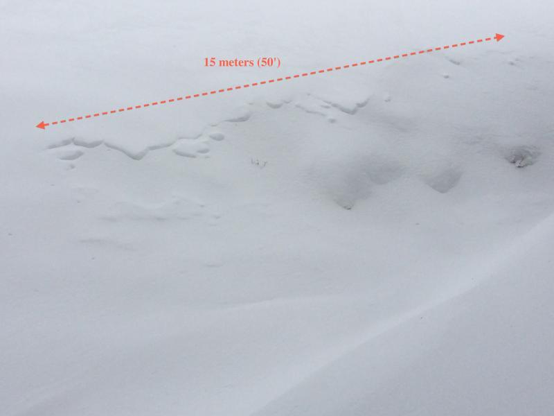
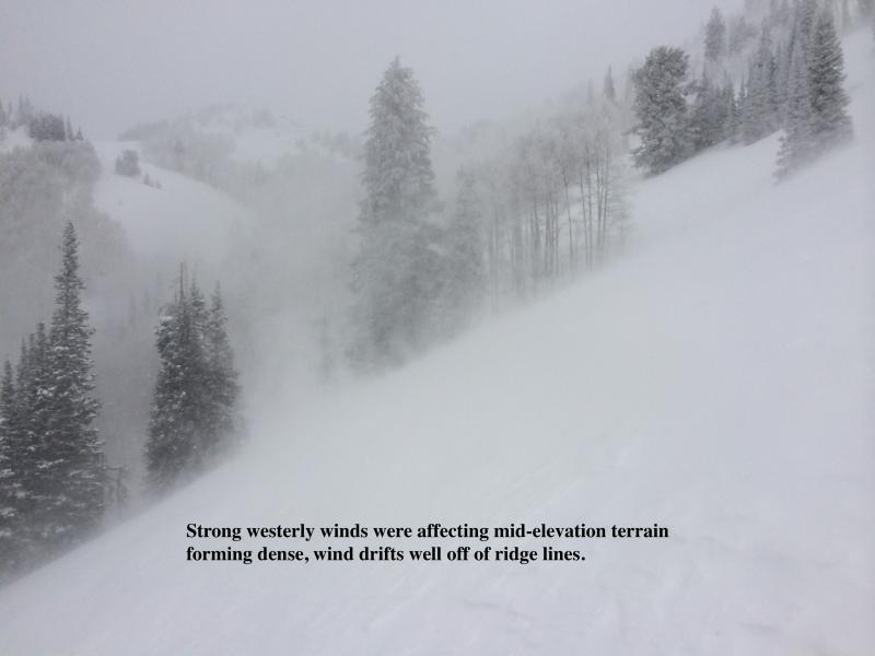
[I'm no Mark White, but photos are of (1) recent natural in mid-elevation terrain trap where crown has filled in with storm snow, and (2) the occasionally strong winds affecting mid-elevation terrain.]

Today's Observed Danger Rating
High
Tomorrows Estimated Danger Rating
Considerable