

Forecast for the Logan Area Mountains

Friday morning, January 10, 2014
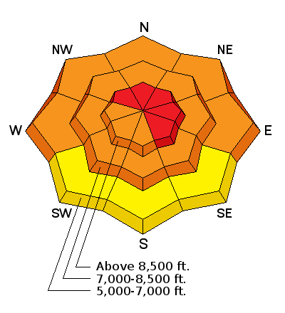
There is a HIGH or Level 4 danger, and avalanches are likely on drifted upper elevation slopes in the backcountry. Dangerous avalanche conditions are developing on many slopes at mid and lower elevations as well. Very dangerous avalanche conditions already exist in some areas, and with additional accumulations and continued sustained and strong westerly winds expected today, the danger will continue to rise and become more widespread heading into the weekend. Triggered wind slab, storm snow, and dangerous persistent slab avalanches are likely on steep slopes, and large natural avalanches are increasingly possible. Avoid travel in avalanche terrain today, stay out from under steep slopes and obvious or historic avalanche paths.
Avalanche Watch
THIS AVALANCHE WATCH IS FOR THE MOUNTAINS OF NORTHERN AND CENTRAL UTAH INCLUDING THE BEAR RIVER (LOGAN)...WASATCH...AND MANTI SKYLINE RANGES. A SERIES OF STORMS WITH STRONG WINDS HAS INCREASED THE AVALANCHE DANGER TO HIGH ON SOME SLOPES. THE AVALANCHE DANGER WILL CONTINUE TO INCREASE THROUGH THE WEEKEND. BACKCOUNTRY TRAVELERS SHOULD AVOID TRAVEL ON AND BELOW STEEP SLOPES. THIS WATCH DOES NOT INCLUDE SKI AREAS OR HIGHWAYS WHERE AVALANCHE CONTROL IS NORMALLY DONE.
 Special Announcements
Dangerous and scary avalanche conditions exist and are becoming more widespread in the backcountry this weekend. Consider riding the lifts to take safer advantage of the deepest powder conditions yet in 2014. Discount lift tickets are available at Backcountry.com - Thanks to Ski Utah and the Utah Resorts, including Beaver Mountain. All proceeds go towards paying for Utah Avalanche Center avalanche and mountain weather advisories.
 Weather and Snow
The Tony Grove Snotel at 8400' reports over a foot of new snow in the last 24 hours, containing 1.3 inches of water. It's 16 degrees this morning, and there is 48 inches of total snow containing 75% of average water content for the date. I am reading increasing west winds again this morning at both the UDOT Hwy 89 Logan Summit and the Mt. Ogden wind sensors, with 40 mph average southwest winds and gusts to 50 on Mt. Ogden and 25 mph average wind speeds at the UDOT sheds in upper Logan Canyon. Similar readings during yesterday's blizzard. The 9700' Logan Peak weather station reports 12 degrees, and southwest winds, but I'm not trusting the unusually light windspeed readings..
I found the rapidly accumulating snow yesterday slightly inverted or a bit heaver on top, and obvious significant drifting was ongoing when I headed down canyon in the mid afternoon. Observers also reported difficult trail breaking in the deep powder and underlying weak sugary snow and red flags including rapid accumulation, extensive drifting, and cracking.
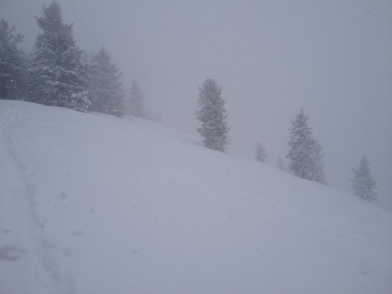
Poor visibility, heavy snowfall, and extensive drifting in Garden City Bowls on 1-9-2014. (McAvoy)
 Recent Avalanches
Ski areas in the Wasatch Range report active avalanche control yesterday, with easily triggered wind slabs. Locally, i was able to trigger small soft slabs on small test slopes in the backcountry near Beaver Mt. yesterday afternoon. I noticed some natural activity involving the new snow in Logan Canyon below Temple Fork. Waiting for observed evidence of natural activity today.....

Persistent Weak Layer
Description
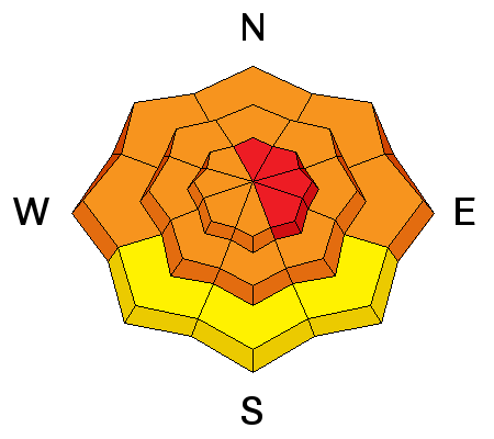
Dangerous wind slab avalanche conditions exist in exposed upper elevation terrain, and the danger will increase and become more widespread during the day as more snow accumulates and is drifted by increasingly strong west winds. Triggered wind slab avalanches are likely on steep slopes with recent deposits of drifted snow. Wind slabs generally form on the lee side of exposed ridge lines, but can also form on any slope aspect, especially in and around terrain features like gullies, scoops, sub-ridges, rock outcroppings, and cliff bands. Avoid steep slopes with recent wind deposits, which are often smooth, rounded and chalky looking, and can sound hollow or drum-like. It is possible that a smaller wind slab avalanche could step down into weak old snow, producing a larger more dangerous avalanche. Triggered and natural sluffs and soft slabs involving the fresh storm snow are likely in steep terrain, and you should avoid traveling below steep slopes, especially during periods of particularly heavy snowfall or gusty winds when natural avalanches will be the most likely.
New Snow
Description
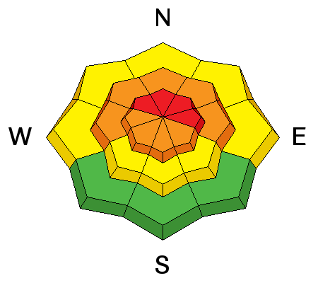
We still don't know if enough loading occurred yesterday to reactivate widespread persistent weak layers, but with all the obvious drifting going on I suspect at least some avalanches will step down into old snow today. Dangerous human triggered avalanches failing in old weak faceted snow or in the basal layers of the existing snow pack are likely on slopes with poor snow structure, especially in drifted upper elevation terrain. New snow from yesterday or accumulating in the next couple days is likely to reactivate the buried weak layers, and persistent slab avalanches will once again top the danger priority list. I've recently found very weak faceted snow on slopes facing every direction and at all elevations, so we'll find a danger of persistent slab avalanches pretty much anywhere a significant slab layer develops. Audible collapsing or whoompfing is a significant red flag indicating serious persistent slab avalanche potential. Drifting, rapid accumulations, other avalanches and cracking are other red flags to take heed of today. As more new snow piles up creating a cohesive slab layer, it is becoming more likely that you could trigger avalanches remotely, from a distance, or worse, from below.
Additional Information
We'll see more stormy weather in the mountains today, sustained and strong westerly winds, and periods of heavy snowfall, with 3 to 5 inches of additional accumulation forecast by this evening. Expect 8500' high temperatures around 25 degrees. Snowfall will continue tonight and decrease tomorrow, with westerly winds remaining in the strong category. Stormy weather should continue through much of the weekend, with another strong frontal passage, with heavy snowfall, and strong winds expected Saturday night and into Sunday.
Check out our one stop weather page........HERE
General Announcements
Utah Avalanche Center mobile app - Get your advisory on your iPhone along with great navigation and rescue tools.
-The Utah Avalanche Center along with the Montana State University Ski Tracks project combines GPS technology with detailed logbook surveys completed by participants to help us understand how and why decisions are made in the winter backcountry. Participants will use a free smartphone app to record and send us their ski routes then, they will complete a simple online survey telling us some of the features of their tour. For more information visit: www.montana.edu/snowscience/tracks
Benefit the Utah Avalanche Center when you shop from Backcountry.com or REI: Click this link for Backcountry.com or this link to REI, shop, and they will donate a percent of your purchase price to the UAC. Both offer free shipping (with some conditions) so this costs you nothing!
Benefit the Utah Avalanche Center when you buy or sell on ebay - set the Utah Avalanche Center as a favorite non-profit in your ebay account here and click on ebay gives when you buy or sell. You can choose to have your seller fees donated to the UAC, which doesn't cost you a penny.
Remember your information can save lives. If you see anything we should know about, please participate in the creation of our own community avalanche advisory by submitting snow and avalanche conditions. You can also call us at 801-524-5304 or 800-662-4140, email by clicking HERE, or include #utavy in your tweet or Instagram.
Follow us at UAClogan on Twitter
I'll issue these advisories on Monday, Wednesday, Friday, and Saturday mornings.
This advisory is produced by the U.S.D.A. Forest Service, which is solely responsible for its content. It describes only general avalanche conditions and local variations always exist.