

Forecast for the Uintas Area Mountains

Sunday morning, January 5, 2014
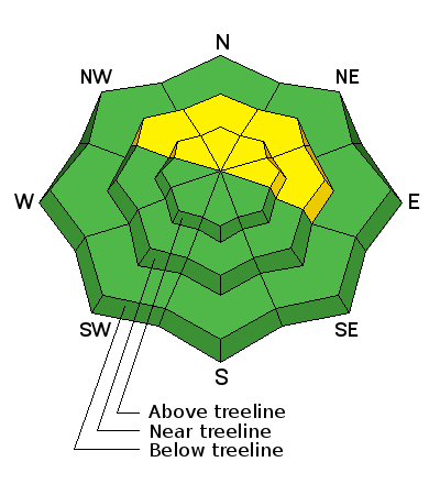
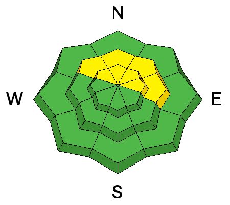
Terrain to avoid- steep, upper elevation slopes facing the north half of the compass, where a MODERATE avalanche danger is found and human triggered avalanches are possible. Once initiated, today's avalanches may break deeper and wider than you'd expect, creating an unmanageable and dangerous slide.
If you're looking for LOW avalanche danger, head to wind sheltered terrain where there are no steep slopes above or adjacent to where you're riding.
 Special Announcements
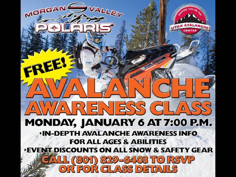
Please join us at 7:00 on Monday Jan. 6th at Morgan Valley Polaris for a free avalanche awareness class for sledders... by sledders.
Give the gift of STOKE! There are still a few slots open for our Avalanche and Riding Skills Workshop with Boondockers. Click here for more info.
 Weather and Snow
Yesterday's storm continued to stack up snow throughout the day, and we've received 6" of light density snow in the past 24 hours. Under clear skies, temperatures crashed into the single digits overnight. West and northwest winds increased at midnight and are blowing 30-50 mph along the high ridges, producing a wind chill near -35 degrees along the peaks. While it might not be "the best day ever", riding and turning conditions have certainly improved. Wind sheltered, mid elevation slopes continue to be the place to find soft, settled snow..
Click here for current winds, temperatures, and snowfall throughout the range.
Click here for trip reports and avalanche observations.
 Recent Avalanches
No significant new avalanche activity to report.

New Snow
Description
This was a nice little storm for the region and there's plenty of light density snow to blow around. With a spike in wind speeds overnight, I suspect today's drifts will be more widespread and more sensitive to the additional weight of a rider. Found mostly along the leeward side of upper elevation ridges, I wouldn't be too surprised to find a sensitive piece of snow cross-loaded around terrain features like chutes or gullies. Today's shallow wind slabs are a manageable avalanche problem because they break at or below our skis, board, or sled. However, not so manageable is the potential for a fresh wind drift to break into weaker snow, now buried several feet deep in our snowpack. Once triggered, a seemingly manageable wind slab can quickly get out of hand, breaking deeper and wider than you might expect, producing a dangerous slide.
Steep, rocky, upper elevation slopes facing the north half of the compass are in the avalanche bulls-eye today. Given the shallow snowpack conditions right now, an avalanche that breaks to the ground will take you for a season ending, body beating ride through rocks and stumps barely hidden under this thin veil of snow.

Our main man Ted Scroggin submitted this snowpit from Friday. While not quite as reactive as even a few days ago, the snowpack continues to fail on weak snow near the ground, right at the level of Ted's snow saw. His trip report can be found here.
Additional Information
Mostly sunny skies are on tap, but west and northwest winds are overstaying their welcome and will continue to blow 30-50 mph along the ridges. Temperatures slowly warm into the teens before crashing into negative territory overnight.High pressure builds tonight through Monday bringing a strong warming trend and diminishing winds. A weak storm is slated for late Tuesday or early Wednesday. After that, there's a few hit or miss storms, but nothing big on the horizon..
General Announcements
Remember your information can save lives. If you see anything we should know about, please participate in the creation of our own community avalanche advisory by submitting snow and avalanche conditions. You can call me directly at 801-231-2170, email [email protected], or email by clicking HERE
This is a great time of year to schedule a free avalanche awareness presentation for your group or club. You can contact me at 801-231-2170 or email [email protected]
Donate to your favorite non-profit –The Utah Avalanche Center. The UAC depends on contributions from users like you to support our work.
Benefit the Utah Avalanche Center when you buy or sell on ebay - set the Utah Avalanche Center as a favorite non-profit in your ebay account here and click on ebay gives when you buy or sell. You can choose to have your seller fees donated to the UAC, which doesn't cost you a penny.
Utah Avalanche Center mobile app - Get your advisory on your iPhone along with great navigation and rescue tools.
The information in this advisory is from the US Forest Service which is solely responsible for its content. This advisory describes general avalanche conditions and local variations always occur.
I will update this advisory by 7:00 AM on Wednesday Jan. 8, 2014