Observation Date
4/28/2013
Observer Name
Coyne
Region
Salt Lake
Location Name or Route
Deseret Peak
Weather
Sky
Clear
Wind Direction
West
Wind Speed
Light
Snow Characteristics
Snow Surface Conditions
Powder
Melt-Freeze Crust
Damp
Snow Characteristics Comments
Good corn cycle happening on all aspect, besides the 'hot pow' we encountered in the NW chute
Red Flags
Red Flags
Recent Avalanches
Rapid Warming
Poor Snowpack Structure
Avalanche Problem #1
Problem
Wet Snow
Trend
Increasing Danger
Problem #1 Comments
Rapid warming observed on North and Eastern aspects. Hanging snow patches saw the sun well before the terrain we planned on traveling.
Avalanche Problem #2
Problem
New Snow
Trend
Decreasing Danger
Problem #2 Comments
Shaded northerly aspects in the Stansbury Mountains appeared to have seen attain significant grappel from the storms around the 20th of April. A nice rime crust sat on top of that. Mostly consolidated snow beneath it all, some suncrust layering, but fairly consistent. This appeared to help small point releases gain momentum and travel further distances as warming from above caused the hanging snowfields to "bomb-drop" onto the slopes below. Luckily I think we saw enough heat yesterday that even those northerly slopes got scorched by the end of the day.
Snow Profile
Aspect
Northwest
Slope Angle
38°
Comments
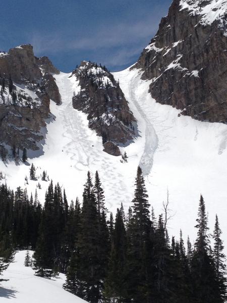
After skiing the Northwest chute of the Twin Chutes, we sat around in a safe spot to literally watch the mountains fall apart. These avalanches went off like vicious thunderstorm. One of the snowfields fell off into the Northeastern chute. See pic below
Video
Coordinates