

Forecast for the Salt Lake Area Mountains

Thursday morning, April 18, 2013
1) Stay off of--and out from underneath--any slope approaching 35 degrees or steeper that is getting wet from the strong sun, which will be mostly on slopes facing the south half of the compass. There is a Considerable avalanche danger on these slopes.
2) Continue to avoid steep slopes with recent wind drifts, which will look smooth and rounded and often crack under your weight.
 Special Announcements
We have ended our regular morning advisories for the season but I will issue intermittent advisories as conditions warrant until about the end of April for the Salt Lake region only. I will still post observations from you each evening and early morning as well, so if you're getting out, please let everyone in our community know what you find. Most of the rest of our staff is off for the season--or will be soon as soon as some projects are completed and most of the ski resorts are closed for the season, so your feedback and observations are important.
A memorial service to celebrate the life of Craig Patterson will take place today, April 18th at 10am at the Albion Grill, Alta. Craig was a Utah Department of Transportation avalanche forecaster who was tragically killed in the line of duty last week. Photos of Craig are welcome. In lieu of gifts or flowers, please contribute to the Craig Patterson Memorial Fund at any Key Bank. Or checks can be sent to the Craig Patterson Memorial Fund 520 Crestview Dr Park City, UT 84098.

Here's a photo I took of Craig a couple summers ago. He was the best of the best. We will all miss you, friend.
 Weather and Snow
It's been quite a storm. Yesterday, it was full on winter complete with a cold, stiff wind and continued snow squalls. The upper Cottonwood Canyons have up to 20 inches of storm total snow (which has settled to much less than that) with over an inch of water weight. Overnight temperatures continued very cold in the lower teens and even one reading of 8 degrees at Brighton. Winds blew yesterday from the north and northwest 20, gusting to 30. Skies are clear and they will remain so all day. The snow is somewhat sun crusted on most aspects but there is still lots of creamy, dry snow on the shady aspects that feels just like a January storm.
As always, check the Snow Page for more details.
 Recent Avalanches
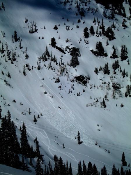
With some intermittent sun peeking through the clouds, wet sluffs gave us a precursor of what to expect today with full-on sun. Here's a photo from Bruce Engelhard. See his complete observation and Greg Gagne's ob. In addition, myself and others were able to find some localized, sensitive wind slabs along the upper elevation ridges from moderate wind from the northwest. Finally, some of the new snow was sluffing as dry sluffs on the shady slopes.
Wet Snow
Description
The main problem today will be wet avalanches. Today the strong spring sun will blaze away in full force for the first time on all this new snow. Snow does not like rapid change and today over a foot of dry, new snow will get wet in a hurry. Today we will see fairly widespread wet sluffs and occasional wet slabs within the new snow on all the steep slopes that face the south half of the compass. With the sun so high in the sky, we will likely see some activity on other aspects as well. So today, definitely stay off of--and out from underneath--any slope approaching 35 degrees or steeper when they get wet in the strong sun. Although there is no snow on southerly facing slopes below 8,000', some of these larger sluffs could descend onto dry ground.
Remember most of the ski resorts, with the exception of Snowbird and Brighton, are closed for the season so treat them like backcountry terrain.
If you're headed to the Uinta Mountains, remember they always have a more unstable snowpack with the potential to break into deeper, persistent weak layers so the avalanche danger is almost always a notch higher on the scale than for the Wasatch Range. HERE is the last advisory for the western Uintas.
Persistent Weak Layer
Description
With continued wind from the northwest today, we should continue to see some localized wind slabs especially along the upper elevation ridges on the southerly facing slopes, but they could be cross loaded into other aspects as well. As usual, avoid steep slopes with recent wind drifts, which look smooth and rounded and often crack under your weight.
Additional Information
Today will be a glorious day with the strong spring sun blasting down on fresh snow. Bring your strongest sunglasses and a brimmed hat. Temperatures will rapidly warm from the single digits this morning to near freezing. The ridge top winds will continue to blow 20 mph gusting to 30 from the north and northwest. It should be clear tonight as well.
Enjoy this weather while you can because we have another pulse of light snow showers for later on Friday into Saturday, which should give us another few inches of snow. Temperatures should finally warm up to seasonal normals by mid next week.
Cottonwood Canyons Forecast, which you can find on the Snow Page.
Always check your local NWS weather forecast, for example, here is the one for Alta. You can click on any spot in the state for a local forecast. You can also click on the satellite loops, radar loops or the hourly weather graph in the lower right of any forecast.
General Announcements
If you trigger an avalanche in the backcountry - especially if you are adjacent to a ski area – please call the following teams to alert them to the slide and whether anyone is missing or not. Rescue teams can be exposed to significant hazard when responding to avalanches, and do not want to do so when unneeded. Thanks.
Salt Lake and Park City – Alta Central (801-742-2033), Canyons Resort Dispatch (435-615-3322)
Twitter Updates for your mobile phone - DETAILS
Subscribe to the daily avalanche advisory e-mail click HERE.
UDOT canyon closures UDOT at (801) 975-4838
Remember your information can save lives. If you see anything we should know about, please participate in the creation of our own community avalanche advisory by submitting snow and avalanche conditions. You can also call us at 801-524-5304 or 800-662-4140, email by clicking HERE, or include #utavy in your tweet.
Donate to your favorite non-profit –The Friends of the Utah Avalanche Center. The UAC depends on contributions from users like you to support our work.
For a print version of this advisory click HERE.

This advisory is produced by the U.S. Forest Service, which is solely responsible for its content. It describes only general avalanche conditions and local variations always exist. Specific terrain and route finding decisions should always be based on skills learned in a field-based avalanche class.