

Forecast for the Salt Lake Area Mountains
Tuesday morning, April 16, 2013
Most of the problems will be within the new snow.
1) Avoid any steep slope with recent wind deposits, which will usually look smooth and rounded.
2) Regularly jump on small test slopes and dig down with your hand to test how well the new snow is bonding to underlying layers.
3) Watch for wet avalanche activity if skies clear and the snow rapidly warms.
The overall avalanche danger for the Wasatch Range is Moderate and Considerable for the Uinta Mountains.
 Special Announcements
We have ended our regular morning advisories for the season but I will issue intermittent advisories as conditions warrant until about the end of April for the Salt Lake region only. I will still post observations from you each evening and early morning as well, so if you're getting out, please let everyone in our community know what you find. Most of the rest of our staff is off for the season--or will be soon as soon as some projects are completed and most of the ski resorts are closed for the season, so your feedback and observations are important.
We'd like to thank everyone for their support this season. We couldn't do this without the support of our non-profit Friends of the Utah Avalanche Center with Paul Diegel as the Executive Director. We've had much support from our world class mountain resorts, UDOT, our many pro observers, and, of course, you - skiers and riders, snowshoers, and snowmobilers, all passionate about the Greatest Snow on Earth. Thanks.
A memorial service to celebrate the life of Craig Patterson will take place Thursday, April 18th at 10am at the Albion Grill, Alta. Photos of Craig are welcome. In lieu of gifts or flowers, please contribute to the Craig Patterson Memorial Fund at any Key Bank. Or checks can be sent to the Craig Patterson Memorial Fund 520 Crestview Dr Park City, UT 84098.
 Weather and Snow
Can't complain. It's been a nice little snow storm for April. The upper Cottonwood Canyons have about a foot of storm total snow (which has settled to much less than that) with about .8 inches of water weight. I've been locked in staff meetings, etc. but I hear the riding is good. Check out the observations from today on our Observations page . The winds have behaved themselves quite well and temperatures have stayed in the teens and lower 20's so the snow quality has been preserved, for the most part. Overnight, the temperatures were very cold, around 10 degrees.
As always, check the Snow Page for more details.
 Recent Avalanches
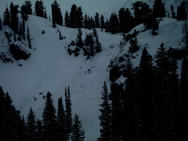
There have been a number of reports of sluffing (small, loose snow slides) within the new snow. One rider was able to trigger a small, shallow wet slab near Brighton (see photo below by Bruce Engelhard). But for the most part, the new snow has been quite well behaved.

Persistent Weak Layer
Description
The winds are forecast to pick up a bit more on Wednesday and blow from the northwest about 20 mph with higher gusts. These may create some deposits of wind drifted snow. As always, avoid any steep slope with recent wind deposits, which will look smooth and rounded and often feel "slabby." In addition, watch for continued sluffing within the new snow. Most of these slides will be small and generally not a problem unless one catches you in dangerous terrain such as a terrain trap, large slope or above cliffs.
Remember most of the ski resorts, with the exception of Snowbird, are closed for the season so treat them like backcountry terrain.
If you're headed to the Uinta Mountains, remember they always have a more unstable snowpack with the potential to break into deeper, persistent weak layers so the avalanche danger is almost always a notch higher on the scale than for the Wasatch Range. HERE is the last advisory for the western Uintas.
Wet Snow
Description
We should have enough cloud cover, cool temperatures and wind to keep wet avalanches in check today, but in case the weather forecast is wrong and we get sun and heating, the new snow will turn wet in a hurry and you will have to deal with the usual damp to wet avalanches as the new, cold snow turns wet for the first time. It will create sluffs on steep slopes. As usual, get off of--and out from underneath--any steep slopes when the snow becomes wet. On Thursday skies should clear and we will probably have a widespread wet avalanche problem as the new snow heats up for the first time. Expect a Considerable danger on Thursday for wet activity.
Additional Information
We should have the last gasp of this large trough over the western U.S today. We should have continued light snow showers Wednesday with 1-3 inches of new snow. Temperatures should remain cool, in the lower 20's. The winds are forecasted to come up and blow harder from the northwest around 20 mph with gusts to 30. It should finally clear out on Thursday before another weak pulse of light snow comes through Friday.
Cottonwood Canyons Forecast, which you can find on the Snow Page.
Always check your local NWS weather forecast, for example, here is the one for Alta. You can click on any spot in the state for a local forecast. You can also click on the satellite loops, radar loops or the hourly weather graph in the lower right of any forecast.
General Announcements
If you trigger an avalanche in the backcountry - especially if you are adjacent to a ski area – please call the following teams to alert them to the slide and whether anyone is missing or not. Rescue teams can be exposed to significant hazard when responding to avalanches, and do not want to do so when unneeded. Thanks.
Salt Lake and Park City – Alta Central (801-742-2033), Canyons Resort Dispatch (435-615-3322)
Twitter Updates for your mobile phone - DETAILS
Subscribe to the daily avalanche advisory e-mail click HERE.
UDOT canyon closures UDOT at (801) 975-4838
Remember your information can save lives. If you see anything we should know about, please participate in the creation of our own community avalanche advisory by submitting snow and avalanche conditions. You can also call us at 801-524-5304 or 800-662-4140, email by clicking HERE, or include #utavy in your tweet.
Donate to your favorite non-profit –The Friends of the Utah Avalanche Center. The UAC depends on contributions from users like you to support our work.
For a print version of this advisory click HERE.

This advisory is produced by the U.S. Forest Service, which is solely responsible for its content. It describes only general avalanche conditions and local variations always exist. Specific terrain and route finding decisions should always be based on skills learned in a field-based avalanche class.