

Forecast for the Uintas Area Mountains

Wednesday morning, April 10, 2013
In the wind zone, at and above treeline, the avalanche danger is CONSIDERABLE and human triggered avalanches are likely on steep, wind drifted slopes. Once initiated, today's avalanches have the potential to break deep and wide, creating a large and dangerous slide.
A MODERATE danger exists on steep wind drifted slopes at mid elevation and human triggered avalanches within the new storm snow are possible.
Out of the wind and on low angle slopes the avalanche danger is generally LOW.
 Special Announcements
This Sunday April 14th will be the last of our regularly scheduled advisories
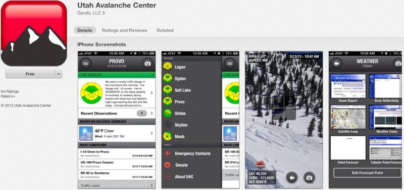
iPhone & iPad users: With help from Backcountry.com & Garafa, LLC, we now have a free mobile app that combines the best of the UAC advisories, observations, and weather summaries with National Weather Service products & UDOT road updates. This puts the tools you need for planning your day and your run in one handy mobile package. Check it out, tell your friends, and let us know what you think. http://utahavalanchecenter.org/apps
 Weather and Snow
The good news is... Monday's storm produced a great shot of snow for the Uinta's, delivering a solid 16" of snow and 1.5" H2O, with the North Slope receiving the Lions Share. The bad news is... the wind. East and northeast winds started ramping up into the 20's and 30's early yesterday afternoon and steadily increased into the 50's and 60's, blowing all night. As of 5:00 this morning they've mellowed slightly, but are still in the 30's and 40's. Under clear skies, temperatures are in the single digits. Out of the wind in sheltered terrain, good cold powder on a go-anywhere base is producing excellent late season riding and turning conditions.
Recent observations can be found here.
Wondering why last winter was so crazy? Click here to watch the 2011-12 Utah Winter Review... an excellent recap of last years conditions.
 Recent Avalanches
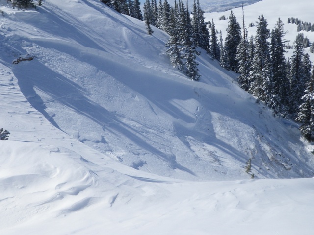
Triggered yesterday from a rocky section of terrain near the ridge where the snowpack was thin and weak, this slide in Humpy Basin broke 3'-5' deep and failed on January depth hoar.... same layer as the big Super Bowl slide pictured below.
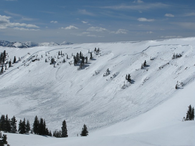
This very large natural slide in the Super Bowl occurred around 11:00 on the morning of the 3rd as a result of heavy storm snow and rapid warming. The crown was over 1/2 mile wide, averages 30" in depth, and broke to weak old snow formed during the January dryspell. Click here for a description explaining the slide and snowpack conditions leading to this very unusual event.
Click here for recent observations from the region.

New Snow
Description
There's a clear trend with our recent string of deeply triggered slides. Each time the snowpack gets rapidly loaded with snow, water, and wind we see avalanches breaking to the ground. The crazy thing is, it's April and we should have a strong solid snowpack, but this year it's different and the cold dryspell during January sealed the deal, helping to create and then preserve a very weak layer of sugary snow. Click here for a video describing the setup.
Making conditions more sketchy is that you can ride plenty of slopes and be good to go, but if you find the right combination of strong snow overlying weak sugary snow chances are you're gonna collapse the slope and be staring down the barrel of a very dangerous slide. Our problem child hasn't gone away and steep, rocky slopes remain suspect. If you're travels take you onto a snowpack that feels punchy and you find yourself sinking into weak sugary snow, carefully evaluate the kind of terrain you're headed to and the kind of terrain you're connected to. Rather than complicating matters, you can avoid avalanches altogether and still have a blast carving on low angle slopes today.
Persistent Weak Layer
Description
There's no shortage of light density storm snow to blow around and the east-northeast winds are raging along the ridges. Blowing from an unusual direction, today you can expect to find sensitive drifts forming in unusual locations, especially in terrain with a westerly component to its aspect. In addition, look for and avoid fat, rounded pillows of snow on any steep slope and remember that terrain features like chutes and gullies have been crossloaded by the wind. While todays fresh slabs may seem mostly manageable, once triggered it's gonna be a different story and they'll be packing a punch. It's a good day to tweak small test slopes and road cuts to see how they're reacting before getting after big terrain.
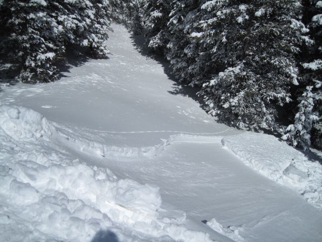
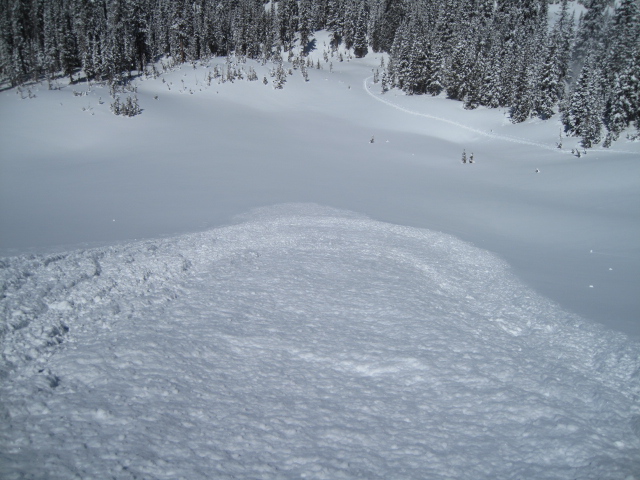

Our main man Ted Scroggin took this series of pics yesterday near Moffit Peak which clearly illustrate the new snow instabilities.
Additional Information
A short-lived ridge of high pressure is building and it'll be a spectacular day in the mountains.Look for sunny skies with temperatures climbing into the low 30's. East and northeast winds are going to be obnoxious with averages in the 20's and 30's and gusts to 50 mph along the high peaks. A warm and moist system slides through the region late tonight into Thursday, bringing 2"-4" of snow to the region with clear skies developing for Friday and Saturday before an extended wet and cool period develops Sunday into next week.
General Announcements
Remember your information can save lives. If you see anything we should know about, please participate in the creation of our own community avalanche advisory by submitting snow and avalanche conditions. You can call me directly at 801-231-2170, email [email protected], or email by clicking HERE
This is a great time of year to schedule a free avalanche awareness presentation for your group or club. You can contact me at 801-231-2170 or email [email protected]
Donate to your favorite non-profit –The Friends of the Utah Avalanche Center. The UAC depends on contributions from users like you to support our work.
The information in this advisory is from the US Forest Service which is solely responsible for its content. This advisory describes general avalanche conditions and local variations always occur.
The information in this advisory expires 24 hours after the date and time posted, but will be updated by 7:00 AM Saturday April 13th.