

Forecast for the Uintas Area Mountains

Monday morning, April 8, 2013
As the storm develops, strong winds and heavy snow will create a rising avalanche danger today. In the wind zone, at and above treeline, the danger will bump from MODERATE to CONSIDERABLE and human triggered avalanches will be likely on steep, wind drifted slopes. Once initiated, today's avalanches have the potential to break deep and wide, creating a large and dangerous slide.
Out of the wind and on low angle slopes the avalanche danger is generally LOW.
 Special Announcements
A large Pacific storm is slated to impact the region the next few days and the avalanche danger will be on the rise. I will update this advisory throughout the week accordingly. Next Sunday April 14th will be the last of our regularly scheduled advisories
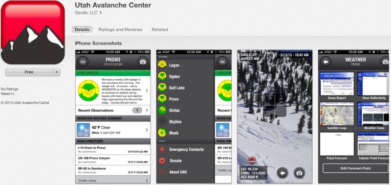
iPhone & iPad users: With help from Backcountry.com & Garafa, LLC, we now have a free mobile app that combines the best of the UAC advisories, observations, and weather summaries with National Weather Service products & UDOT road updates. This puts the tools you need for planning your day and your run in one handy mobile package. Check it out, tell your friends, and let us know what you think. http://utahavalanchecenter.org/apps
 Weather and Snow
A powerful winter storm is at our doorstep and light snow began falling early this morning. Southwest winds gusted into the 50's along the high ridges overnight, but for the meantime have mellowed into the 20's and 30's. Currently, temperatures are in the mid to upper 20's. Might be a good day to get some projects done in the morning and get after it late today once some fresh snow has stacked up.
From hero to zero. The lower elevations took a hard hit this week as warm temperatures and light rain have taken their toll.
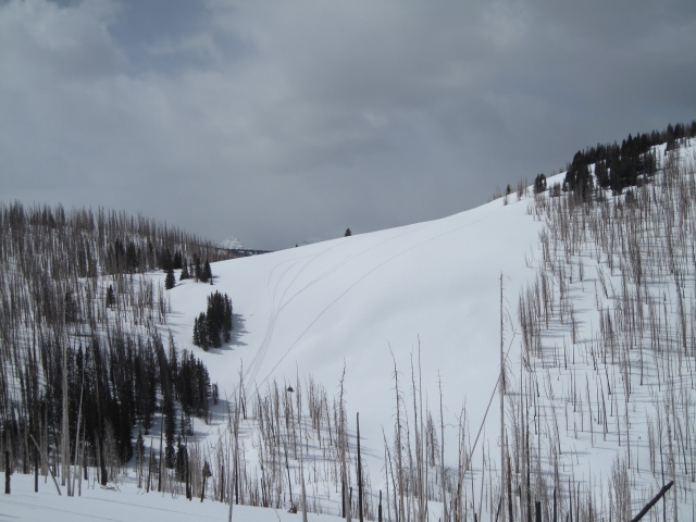
Up high it's a different story.
Recent observations can be found here.
Wondering why last winter was so crazy? Click here to watch the 2011-12 Utah Winter Review... an excellent recap of last years conditions.
 Recent Avalanches
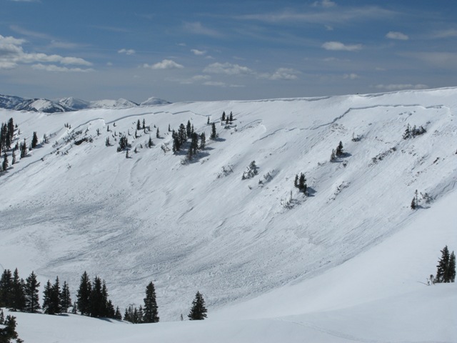
The region received a one-two punch last week... heavy, dense snow and a rapid warm up conspired against our weak snowpack. This very large natural slide in the Super Bowl occurred around 11:00 on the morning of the 3rd. The crown was over 1/2 mile wide, averages 30" in depth, and broke to weak old snow formed during the January dryspell. Click here for a description explaining the slide and snowpack conditions leading to this very unusual event.
Click here for recent observations from the region.

New Snow
Description
It's remarkable to me that we're still taking about avalanches breaking to the ground and here it is the first week of April when we're usually enjoying manageable avalanches conditions on a solid, go anywhere base. This year it's different and the cold dryspell during January sealed the deal, helping to create and then preserve a very weak base. Up until the last series of storms we were good to go because there was no slab. Now however, the storm snow has settled and consolidated into a dense layer of snow. Unfortunately it rests on a persistent weakness (a very weak layer of depth hoar) and we've got all the ingredients for an unmanageable avalanche. Making conditions more sketchy is that you can ride plenty of slopes and be good to go, but if you find the right combination of strong snow overlying weak sugary snow chances are you're gonna collapse the slope and be staring down the barrel of a very dangerous slide. Our problem child hasn't gone away and steep, rocky slopes remain suspect. If you're travels take you onto a snowpack that feels punchy and you find yourself sinking into weak sugary snow, carefully evaluate the kind of terrain you're headed to and the kind of terrain you're connected to. Rather than complicating matters, you can avoid avalanches altogether and still have a blast carving on low angle slopes today.
Persistent Weak Layer
Description
Winds are gonna be all over the place the next 24 hours and fresh wind drifts along the leeward side of upper elevation ridges and around terrain features like chutes and gullies are today's most obvious avalanche dragon. Manageable early in the day, though as the storm develops, expect the drifts to become more widespread and more sensitive. It's a good day to tweak small test slopes and road cuts to see how they're reacting before getting after big terrain.
Additional Information
Steady snow will start to develop in the next few hours and continue through tomorrow night. Storm totals should be right around a foot.Southwest winds gust into the 40's and 50's early, then switch east and northeast by about midday and increase to 60 mph. Temperatures climb into the low 30's before crashing into the teens overnight. A few scattered snow showers linger on Tuesday before high pressure builds for midweek.
General Announcements
Remember your information can save lives. If you see anything we should know about, please participate in the creation of our own community avalanche advisory by submitting snow and avalanche conditions. You can call me directly at 801-231-2170, email [email protected], or email by clicking HERE
This is a great time of year to schedule a free avalanche awareness presentation for your group or club. You can contact me at 801-231-2170 or email [email protected]
Donate to your favorite non-profit –The Friends of the Utah Avalanche Center. The UAC depends on contributions from users like you to support our work.
The information in this advisory is from the US Forest Service which is solely responsible for its content. This advisory describes general avalanche conditions and local variations always occur.
The information in this advisory expires 24 hours after the date and time posted, but will be updated by 7:00 AM Tuesday April 9th.