

Forecast for the Logan Area Mountains

Friday morning, April 5, 2013
Heightened avalanche conditions exist in many areas, and there's a MODERATE (or level 2) danger of wet avalanches on steep slopes in the backcountry. Dangerous natural or triggered wet slab avalanches are possible in some areas. Evaluate the snow and terrain carefully, avoid steep terrain with melt-softened snow, and continue to follow safe travel protocols...
 Special Announcements
iPhone & iPad users: With help from Backcountry.com & Garafa, LLC, we now have a free mobile app that combines the best of the UAC advisories, observations, and weather summaries with National Weather Service products & UDOT road updates. This puts the tools you need for planning your day and your run in one handy mobile package. Check it out, tell your friends, and let us know what you think.http://utahavalanchecenter.
 Weather and Snow
The Tony Grove Snotel at 8400' reports an inch of new snow from overnight, and temperatures dropped to 39 degrees early this morning after sustaining mid-forties balminess for much of the night. With 47"of total snow, the station now contains only 53% of average water for the date. The CSI Logan Peak weather station at 9700' reports dropping temperatures this morning; currently it's 31 degrees with southwest winds averaging in the mid teens, but the station reports a fifty mph gust late last night. With cloud cover and warm overnight temperatures, the saturated snow is probably still punchy and soft in many areas. Gradual cooling and cloud cover today will begin to slow the recently accelerated meltdown....
 Recent Avalanches
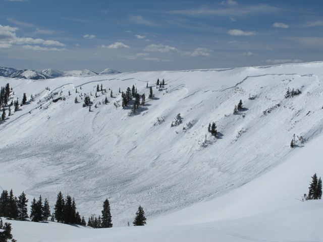
No new avalanches were reported recently in the Logan Area..... But a very large natural heat related persistent slab avalanche occurred in the midday heat on Wednesday in the Western Uintas. Graig Gordon and Ted Scoggins of the Utah Avalanche Center visited the site yesterday and report a 3/4-mile wide and four-foot deep monster....
Here's a link to our updated Avalanche List.
Wet Snow
Description
Gradual cooling and cloud cover today will slow the meltdown and help to solidify the soft and saturated snow, but wet avalanches will remain possible after an exceptionally warm night and an extended warm spell. Heightened avalanche conditions exist in steep terrain. Cornice falls and natural sluffs off rock bands are possible in the midday heat again, and wet slab avalanches are possible in north facing terrain where melt water may be reaching and moistening persistent weak layers. As always, watch for terrain traps like trees or gullies below you. It's best to plan for an early exit this time of year and retreat if you start sinking into warmth softened wet snow, but this may not really be the case today with cooling temperatures after a warm night, and you're likely to be sinking into saturated snow this morning....
Here's a link to Evelyn's blog on Wet Snow Avalanches, in which she notes that 47% of fatalities from wet avalanches are attributed to natural avalanches. This gives us good incentive not to hang out on or under steep slopes in avalanche terrain during the heat of the day when the slushy snow is most likely to avalanche.
Additional Information
Expect gradual cooling, cloud cover, rain below around 8000', and some snow at upper elevations today. High temperatures at 9000' today are expected to be in the upper thirties, (currently 38 at the 8400' Tony Grove Snotel). 2 to 4 inches may accumulate today up high. A moist westerly flow will bring periods of rain to the valleys and snow to upper elevations through the weekend, and a cold Pacific storm will affect the region early next week, but looks to be on a more southerly track.
Check out the Logan Mountain Weather page...
General Announcements
For a printer friendly version of this advisory click HERE
Remember your information from the backcountry can save lives. If you see or trigger an avalanche, or see anything else we should know about, please send us your snow and avalanche observations. You can also call us at 801-524-5304 or email by clicking HERE. In the Logan Area you can contact Toby Weed directly at 435-757-7578.
I will update this advisory on Monday, Wednesday, Friday, and Saturday mornings by around 7:30...
This advisory is produced by the U.S.D.A. Forest Service, which is solely responsible for its content. It describes only general avalanche conditions and local variations always exist.