

Forecast for the Salt Lake Area Mountains

Friday morning, April 5, 2013
Rain, wet snow and warm temperatures will keep the danger of wet avalanches MODERATE. Human triggered avalanches are possible in both the new snow and the old snow on steep slopes of all aspects and elevations. Avoid travel below any of the yawning glide cracks or large cornices, which could release naturally at any time. Stick to low angle terrain and ridgelines, and avoid avalanche run out zones.
 Special Announcements
Drew Hardesty has been working with UDOT and other agencies on proposed avalanche information signage at the base of the Cottonwood Canyons and perhaps other highways heading to popular trailheads. We are looking for a little more public feedback on our two 'yes/no question' survey. CLICK HERE FOR THE SURVEY
Gabe Garcia is doing a study on an unusual day that occurred in upper Little Cottonwood on Nov 13, 2012 involving numerous human triggered avalanches with injuries and a fatality. SURVEY
 Weather and Snow
A heat wave kept mountain temperatures in the 30s, 40s, and even low 50s for much of the night. But a quick moving disturbance is now on our doorstep, and finally, temperatures are beginning to drop as light rain and snow begins to fall. The southerly winds kicked up ahead of the front, into the 15 to 20 mph range, with a few of the highest peaks averaging 30 to 40 mph, with gusts in the 50s.
The snowpack will range from damp and supportable to wet and soggy this morning, and any surface refreeze will be very shallow.
 Recent Avalanches
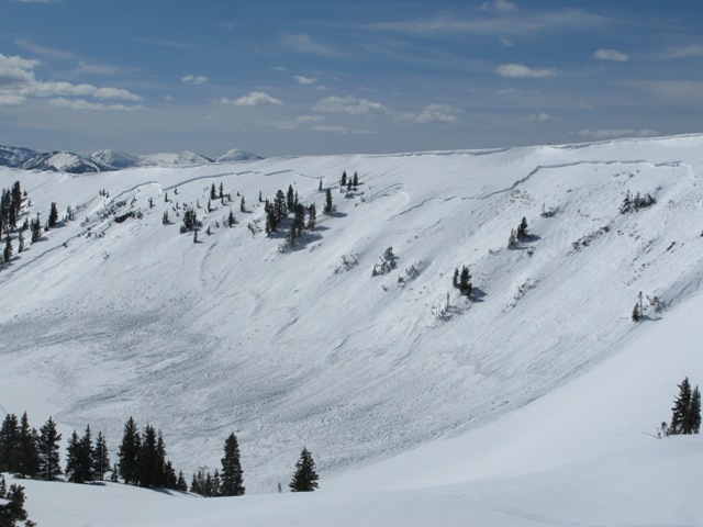
Another large glide avalanche released off of the west facing rock slabs in Stairs Gulch, Big Cottonwood Canyon. This one started around 9500’, and is estimated to be 8 feet deep where it broke. There was a spectacular natural avalanche Wednesday in the Western Uintas, showing how weaker snowpack areas are responding to the warming. Check out the details HERE. and photo below - Super Bowl, western Uintas.

Wet Snow
Description
Warm temperatures, rain and fresh damp snow will keep the threat of wet avalanches going through the day. People could trigger loose sluffs on steep slopes in both the soggy old snow and in the new snow that falls today. Also avoid small, but steep terrain features like gullies, creek beds and travel below steep road cuts and couloirs where even a small slide can pile up debris deeply.
Another concern are pockets of shallow snow, often near rocks, in the mid to upper elevation northerly facing terrain. These shallow areas still harbor some weak snow that is warming for the first time, and perhaps a few surprises are left as the facet layers become damp – the isolated chance of triggering a wet slab avalanche.
Additional Information
A fast moving storm will push a moist “cool” front across the Wasatch this morning, bringing 2 to 4” of new snow at the upper elevations and a 10% chance of lightning. 10,000’ temperatures will cool into the upper 20s as the snow arrives, and then into the mid-20s by evening. 8,000’ temperatures will be in the upper 30s. The rain/snow line will slowly drop from 8,000’ to 7,000’. The gusty southwesterly winds will shift to a more westerly direction, and gradually decrease into the 5 to 15 mph range, with average speeds dropping to 20 mph at the higher elevations.
A moist, westerly flow will continue over the area through the weekend. After a brief break tonight, another few inches of snow are possible Saturday morning, and again on Sunday. A colder stronger storm will reach northern Utah Sunday night, bringing a final round of snow to the northern mountains through Monday.
General Announcements
Go to http://www.backcountry.com/utah-avalanche-center to get EVEN MORE DISCOUNTED tickets from our partners at Beaver Mountain and Sundance. All proceeds benefit the Utah Avalanche Center.
If you trigger an avalanche in the backcountry - especially if you are adjacent to a ski area – please call the following teams to alert them to the slide and whether anyone is missing or not. Rescue teams can be exposed to significant hazard when responding to avalanches, and do not want to do so when unneeded. Thanks.
Salt Lake and Park City – Alta Central (801-742-2033), Canyons Resort Dispatch (435-615-3322)
Ogden – Snowbasin Patrol Dispatch (801-620-1017)
Powder Mountain Ski Patrol Dispatch (801-745-3772 ex 123)
Provo – Sundance Patrol Dispatch (801-223-4150)
Dawn Patrol Forecast Hotline, updated by 05:30: 888-999-4019 option 8.
Twitter Updates for your mobile phone - DETAILS
Daily observations are frequently posted by 10 pm each evening.
Subscribe to the daily avalanche advisory e-mail click HERE.
UDOT canyon closures UDOT at (801) 975-4838
Wasatch Powderbird Guides does daily updates about where they'll be operating on this blog http://powderbird.blogspot.com/ .
Remember your information can save lives. If you see anything we should know about, please participate in the creation of our own community avalanche advisory by submitting snow and avalanche conditions. You can also call us at 801-524-5304 or 800-662-4140, email by clicking HERE, or include #utavy in your tweet.
Donate to your favorite non-profit –The Friends of the Utah Avalanche Center. The UAC depends on contributions from users like you to support our work.
For a print version of this advisory click HERE.
This advisory is produced by the U.S. Forest Service, which is solely responsible for its content. It describes only general avalanche conditions and local variations always exist. Specific terrain and route finding decisions should always be based on skills learned in a field-based avalanche class.