Forecast for the Logan Area Mountains

Toby Weed
Issued by Toby Weed for
Saturday, March 23, 2013

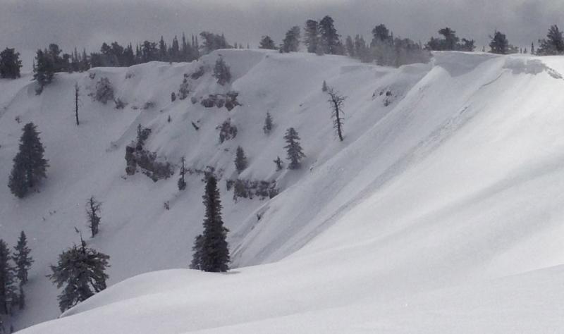
Heightened avalanche conditions exist in the backcountry, and there's a MODERATE (level 2) danger on drifted slopes at mid and especially upper elevations. You might trigger 1 to 2-foot-deep wind slab avalanches on steep slopes with recent deposits of drifted snow. Recently enlarged ridge-top cornices are sensitive to human weight and might break further back than expected, potentially triggering wind slab avalanches on slopes below. The danger is LOW at lower elevations, in sheltered areas, and in lower angle terrain. Evaluate the snow and terrain carefully, especially in drifted upper elevation areas.

Low
Moderate
Considerable
High
Extreme
Learn how to read the forecast here
Special Announcements

Go to http://www.backcountry.com/utah-avalanche-center to get tickets for Beaver Mountain. You won't save a ton of money, but all proceeds from sales of these tickets will benefit the Utah Avalanche Center, and It's super easy to do.

Weather and Snow

Conditions are good at all elevations, but there is significantly more new snow up high. We found very nice powder and mostly stable snow conditions at upper elevations yesterday. (new Video Observation from 3-22-2013) The Tony Grove Snotel at 8400' reports 3 more inches of accumulation and 3/10ths of an inch of water equivalent in the last 24 hours. It's 8 degrees, and with 67"of total snow, the station sits at 67% of average water for the date. The CSI Logan Peak weather station at 9700' reports a chilly 3 degrees and it looks like the wind sensor is encased in rime.

Recent Avalanches

There were lots of small natural wind slab and cornice-fall avalanches at upper elevations Thursday, and we were easily able to trigger manageable wind slabs in the upper Richard's Hollow Area by knocking small chunks of cornice onto drifted slopes. These fresh soft slabs were around a foot deep and 60 or 70 feet wide, and they ran quickly a good ways down into the bowl below... Yesterday, the wind slabs were less sensitive, but we could easily kick off big chunks the large ridge-top cornices, and some of these were breaking a little further back than expected.

Here's a link to our updated Avalanche List.

Ad
Avalanche Problem #1
Persistent Weak Layer
Type
Location
Likelihood
Size
Description

Sustained and gusty westerly winds in the past couple days drifted fresh snow into lee slopes and deposition areas at upper elevations. Watch for and avoid smooth, stiffer, chalky-looking, and sometimes hollow sounding drifts on steep slopes. You might find fresh drifts in and around terrain features like sub-ridges, cliff bands, or gullies. Accumulations of new snow and continued westerly winds created heightened avalanche conditions at upper elevations today, and you might trigger wind slab avalanches on steep drifted slopes. These might be a bit less manageable today than they were in the past couple days...

Avalanche Problem #2
Cornice
Type
Location
Likelihood
Size
Description

Beware the recently enlarged ridge-top cornices. These big guys are likely to break a lot further back than expected and could take you for a surprise elevator ride... Cornice falls could be fairly large this weekend in terrain exposed to drifting, and they could trigger wind slab avalanches on steep drifted slopes below.

Additional Information

It'll stay fairly cold today, with highs in the lower twenties, moderate northwest winds, and 1 to 2 inches of additional snow possible. Unsettled and cold weather is expected to persist through the weekend. Snow showers will continue tonight, mountain temperatures will drop into the single digits, and moderate northwesterly winds will continue. Snow showers are likely again tomorrow, with little accumulation forecast, sub-twenty degree temperatures in the mountains, and continued westerly winds. Expect clearing and sunshine on Monday and gradual warming, with midweek daytime high temperatures approaching 40 degrees at 9000'.

Check out the Logan Mountain Weather page...

General Announcements

For a printer friendly version of this advisory click HERE

Remember your information from the backcountry can save lives. If you see or trigger an avalanche, or see anything else we should know about, please send us your snow and avalanche observations. You can also call us at 801-524-5304 or email by clicking HERE. In the Logan Area you can contact Toby Weed directly at 435-757-7578.

I will update this advisory on Monday, Wednesday, Friday, and Saturday mornings by around 7:30...

This advisory is produced by the U.S.D.A. Forest Service, which is solely responsible for its content. It describes only general avalanche conditions and local variations always exist.