Forecast for the Uintas Area Mountains

Craig Gordon
Issued by Craig Gordon for
Saturday, March 23, 2013

In the wind zone at and above treeline the avalanche danger is MODERATE and human triggered avalanches are possible on steep, mid and upper elevation, wind drifted slopes.

Out of the wind and on low angle slopes with no steep terrain above or adjacent to where you're riding, you'll find a LOW avalanche danger.

Low
Moderate
Considerable
High
Extreme
Learn how to read the forecast here
Weather and Snow

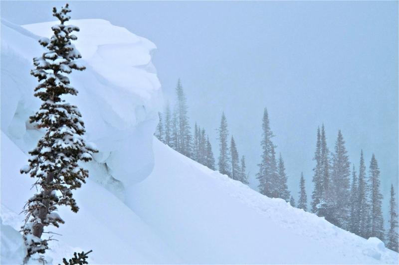
March madness continues on the eastern front and the riding is about as good as it gets. The North Slope has done well with this unsettled pattern where storm totals are nearing 14". The south half of the range from Trial Lake to Daniels has received about half that amount. West and northwest winds have been blowing in the 20's and 30's with a little spike from 3:00-7:00 pm Friday when we saw gusts in the mid 40's along the high peaks. It's winter in the Uintas and temperatures are in the single digits at the trailheads and near zero along the ridges.

Recent observations can be found here.

Our entire Uinta weather station network is up and running. A link to real-time wind, snow, and temperature data can be found here.

This monumental achievement couldn't have happened without the joint efforts from the National Weather Service, The Heber-Kamas and Evanston Ranger Districts, Park City Powder Cats, and all the great work by Ted, Trent, Cody, and Al. Thanks to everyone... this is awesome!

Wondering why last winter was so crazy? Click here to watch the 2011-12 Utah Winter Review... an excellent recap of last years conditions.

Recent Avalanches

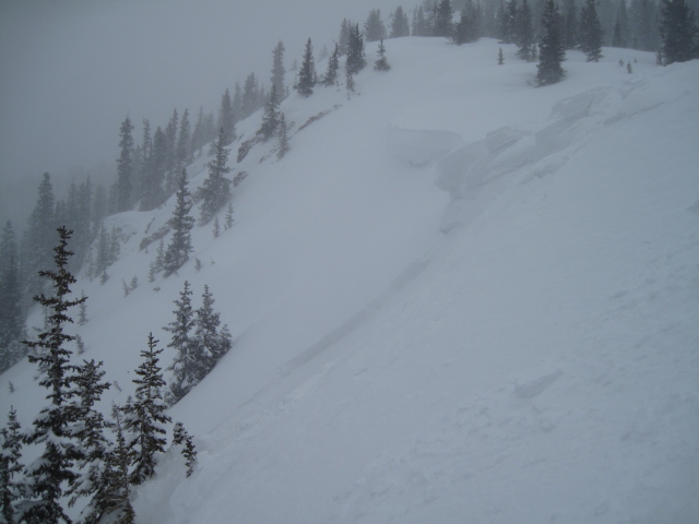
Long running sluffs and shallow soft slabs predictably breaking within the new storm snow were observed yesterday in steep, wind drifted terrain throughout the region.

Click here for recent observations from the region.

Ad
Avalanche Problem #1
Persistent Weak Layer
Type
Location
Likelihood
Size
Description

Talk about the gift that keeps giving! Storm totals are starting to stack up at the upper elevations and in the terrain that we visited the past few days, the snowpack is relatively well behaved. Wind drifts are soft, predictable, and mostly manageable in size and depth. However, all this new snow is resting on a variety of hard, slick bed surfaces and once triggered, today's avalanches have the potential to run a little farther than you might expect and could clobber an unsuspecting group below where you're riding.


This snowpit profile shows the setup.

Avalanche Problem #2
Cornice
Type
Location
Likelihood
Size
Description

Cornices continue to grow and may break back a little further than you might expect. Probably best to steer clear of these unpredictable pieces of snow.

Additional Information

Unsettled weather with scattered snow showers and cold temperatures will be the rule this weekend, as a cold northwest flow camps out over the region through Sunday. Northwest winds should remain in the 15-25 mph range with a few higher gusts possible as impulses of snow slides through the area. High temperatures struggle to get into the mid teens before crashing to near zero tonight. The storm system pulls off to the east tomorrow with snow showers decreasing and we should see partly cloudy skies developing. High pressure brings a lull to the action and a return to sunny skies and warming temperatures for the first half of next week.

General Announcements

Remember your information can save lives. If you see anything we should know about, please participate in the creation of our own community avalanche advisory by submitting snow and avalanche conditions. You can call me directly at 801-231-2170, email [email protected], or email by clicking HERE

This is a great time of year to schedule a free avalanche awareness presentation for your group or club. You can contact me at 801-231-2170 or email [email protected]

Donate to your favorite non-profit –The Friends of the Utah Avalanche Center. The UAC depends on contributions from users like you to support our work.

The information in this advisory is from the US Forest Service which is solely responsible for its content. This advisory describes general avalanche conditions and local variations always occur.

The information in this advisory expires 24 hours after the date and time posted, but will be updated by 7:00 AM Sunday March 24th.