
Forecast for the Ogden Area Mountains

Sunday morning, March 17, 2013
The avalanche danger is MODERATE for the possibility of still triggering a wet avalanche especially in the lower elevations. Natural avalanches are not likely today but caution should be used in the mid and lower elevations.
 Weather and Snow
Temperatures cooled a bit more along the ridges overnight and westerly winds have increased with stronger gusts along the high ridges. A small disturbance moved through this morning producing a trace to 2 inches of snow.
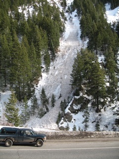
 Recent Avalanches
Wet avalanche activity slowed on Saturday but there were still a number of natural wet avalanches that occurred in the afternoon. They were on a variety of aspects including north at lower elevations. Although seemingly small, the piles of debris are nothing you would want to be tangled in.
DETAILS on recent avalanche cycle with updated photos


Wet Snow
Description
Wet avalanche activity will slow even more today after last nights cool down but the lower elevations should still be approached with caution where the temperatures didn't cool as much. There will still be lots of unconsolidated wet loose snow under the thin refreeze in these areas.
Additional Information
Temperatures should remain in the 20s during the day today as more cold air spills into the area from the northwest. Winds will continue to be a bit gusty from the west northwest. We may see a few clouds move in with the threat of a snow shower or two. I'm not anticipating much accumulation if any.
General Announcements
Go to http://www.backcountry.com/utah-avalanche-center to get tickets from our partners at Beaver Mountain, Canyons, Sundance, and Wolf Mountain. All proceeds benefit the Utah Avalanche Center.
If you trigger an avalanche in the backcountry - especially if you are adjacent to a ski area – please call the following teams to alert them to the slide and whether anyone is missing or not. Rescue teams can be exposed to significant hazard when responding to avalanches, and do not want to do so when unneeded. Thanks.
Salt Lake and Park City – Alta Central (801-742-2033), Canyons Resort Dispatch (435-615-3322)
Ogden – Snowbasin Patrol Dispatch (801-620-1017)
Powder Mountain Ski Patrol Dispatch (801-745-3772 ex 123)
Provo – Sundance Patrol Dispatch (801-223-4150)
Dawn Patrol Forecast Hotline, updated by 05:30: 888-999-4019 option 8.
Twitter Updates for your mobile phone - DETAILS
Daily observations are frequently posted by 10 pm each evening.
Subscribe to the daily avalanche advisory e-mail click HERE.
UDOT canyon closures UDOT at (801) 975-4838Wasatch Powderbird Guides does daily updates about where they'll be operating on this blog http://powderbird.blogspot.com/ .Remember your information can save lives. If you see anything we should know about, please participate in the creation of our own community avalanche advisory by submitting snow and avalanche conditions. You can also call us at 801-524-5304 or 800-662-4140, email by clicking HERE, or include #utavy in your tweet.
Donate to your favorite non-profit –The Friends of the Utah Avalanche Center. The UAC depends on contributions from users like you to support our work.
For a print version of this advisory click HERE.
This advisory is produced by the U.S. Forest Service, which is solely responsible for its content. It describes only general avalanche conditions and local variations always exist. Specific terrain and route finding decisions should always be based on skills learned in a field-based avalanche class.